
Akshayuk Pass
| Akshayuk Pass | ||
|---|---|---|
| Pangnirtung Pass | ||
Elevation 420 m (1,378 ft)[1] | | |
| Location | Baffin Island | |
| Range | Baffin Mountains | |
| Coordinates | 66°40′N 65°08′W / 66.667°N 65.133°W | |
| Topo map | NTS 26I11 Mount Asgard | |
 Location of Akshayuk Pass | ||
Akshayuk Pass[2] formerly Pangnirtung Pass[3] is a mountain pass in the Baffin Mountains of Nunavut, Canada.[4] It is found within Auyuittuq National Park. To the southwest is Mount Thor, about 17 km (11 mi), and Pangnirtung, about 64 km (40 mi) and to the northeast is Qikiqtarjuaq, about 109 km (68 mi).
Geography
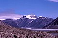
Akshayuk Pass is a U-shaped glacially carved valley on the Cumberland Peninsula of Baffin Island. It is a 97 km (60 mi)[1] long mountain pass which cuts through the southern Baffin Mountains. Two rivers flow from Akshayuk Pass, the Owl river in the north and the Weasel river in the south. The highest point is Summit Lake, which is 420 m (1,380 ft)[1] above sea level.
Akshayuk Pass was carved by
Gallery
-
 Akshayuk Pass from the air, November 2014
 -
 Mount Thor seen from Akshayuk Pass
 -
 Akshayuk Pass and Midnight Sun Peak


References
External links
This article related to a mountain, mountain range, or peak in Canada is a stub. You can help Wikipedia by expanding it. |
This Qikiqtaaluk Region, Nunavut location article is a stub. You can help Wikipedia by expanding it. |