
Auyuittuq National Park
| Auyuittuq National Park | |
|---|---|
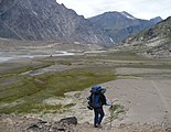
 Pangnirtung Fiord and the Weasel River Valley | |
 Location of Auyuittuq National Park | |
| Location | Nunavut, Canada |
| Nearest city | Pangnirtung, Qikiqtarjuaq |
| Coordinates | 67°53′N 65°01′W / 67.883°N 65.017°W |
| Area | 21,470 km2 (8,290 sq mi) |
| Established | 1972 |
| Governing body | Parks Canada |
Auyuittuq National Park (
Location and access
Auyuittuq National Park is located on the Cumberland Peninsula of Baffin Island in Nunavut. The park is located within the Arctic Circle. The park covers 21,470 square kilometres (8,290 sq mi)[2][note 1] and is located partially within the Penny Highlands and contains the 6,000 km2 (2,300 sq mi) Penny Ice Cap.[2][3] The Penny Ice Cap, made of ice sitting on Precambrian granite, creates a series of glaciers, among them the Coronation Glacier. The land reflects the geological history of the area, with deep valleys between the peaks, which include Mount Asgard with an 800 m (2,600 ft) face, and Mount Thor with a 1,250 m (4,100 ft) face. Along the coast are deep, narrow fjords.[2] In Akshayuk Pass, the winds can reach 175 km/h (109 mph).[4]
The nearest towns are Qikiqtarjuaq and Pangnirtung. Visitors wishing to enter the park are required by Parks Canada to register at the park office in Pangnirtung or Qikiqtarjuaq, and attend an orientation session.[3][4] Park user fees apply.
History
First established in 1972 as Baffin Island National Park, in 1975, Parks Canada chose to rename the park in order to better reflect the landscape and the Inuit history within the region. After some debate, the name was changed to Auyuittuq National Park, which is an Inuktitut word meaning "the place that does not melt".[2]
Flora and fauna
Little vegetation can be found in Auyuittuq Park, although the plants found there range from flowers such as
Because of the exceptionally low vegetation supply on land, wildlife is very scarce. However, the park is bordered on three sides by sea and marine life is found within the park's boundaries.
Activities
The most common backpacking route in the park is known as Akshayuk Pass, and follows the Weasel and Owl rivers via Summit Lake.[4] In 2008, heavy rain and warm weather caused Summit Lake to burst through its banks, flooding the Weasel River and washing away the Windy Lake bridge. As a result, the hiking routes in the pass are limited to either side of the Weasel River.[citation needed]
Gallery
-
 Mount Asgard, Baffin Island, 2001
 -
 Maktak Fiord Delta
 -
 Horseshoe-shaped lateral moraines at the margin of the Penny Ice Cap
 -
 Along the Weasel River, hiking to Mount Thor
 -

-
 Rock formations and glaciers. Turnweather Peak in the middle.
 -
 Weasel River Valley with Schwartzenbach Falls in the distance
 -
 Baffin Mountains from the air, Cumberland Peninsula
 -
 Summit Lake at Akshayuk Pass
 -
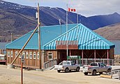 Auyuittuq National Park Office in Pangnirtung


See also
- National Parks of Canada
- List of National Parks of Canada
- List of Nunavut parks
- Arctic Cordillera
Notes
- ^ The Municipality of Pangnirtung website states that the park measures 19,089 square kilometres (7,370 sq mi).
Citations
- ^ "Protected Planet | Auyuittuq National Park Of Canada". Protected Planet. Retrieved 2020-11-05.
- ^ ISBN 0-00-217458-8.
- ^ a b "Auyuittuq National Park". Municipality of Pangnirtung. Archived from the original on 30 January 2019. Retrieved 30 January 2019.
- ^ a b c "Visitor Information Package". Parks Canada. 2017-05-30. Archived from the original on 18 October 2013. Retrieved 30 January 2019.
Further reading
- Ferguson, Steven H; Taylor, Mitchell K; Messier, Francois (1997). "Space Use by Polar Bears in and Around Auyuittuq National Park, Northwest Territories, During the Ice-Free Period". Canadian Journal of Zoology. 75 (10): 1585–1595. doi:10.1139/z97-785.
- Hines, James E.; Moore, Steve (1988). The Vegetation and Flora of Auyuittuq National Park Reserve, Baffin Island (PDF) (Report). Yellowknife, Canada: Department of Renewable Resources, Government of the Northwest Territories. Archived from the original (PDF) on 2016-03-04. Retrieved 2015-05-22.
- Konotepetz, Larry (1985). Archaeological Sites of Auyuittuq National Park Reserve. Microfiche report series, 315. Ottawa, Canada: Environment Canada, Canadian Parks Service. OCLC 59739479.
- Masterton, J. M.; Findlay, B. F. (September 1976). The Climate of Auyuittuq National Park, Baffin Island, Northwest Territories (PDF) (Report). Toronto, Canada: Atmospheric Environment Service, Meteorological Applications Branch, Environment Canada.
- Tarnocai, C. (1998). Monitoring the Integrity of Cultural Sites, Auyuittuq National Park Reserve (Report). Ottawa, Canada: Research Branch (ECORC), Agriculture and Agri-Food Canada.
- Wilson, Roger, ed. (1976). The Land That Never Melts Auyuittuq National Park. Toronto: Peter Martin Associates Limited in association with Indian and Northern Affairs and Pub. Centre, Supply and Services Canada. ISBN 0-88778-143-8.
External links
- Parks Canada official site
- Mount Thor Peak climbing info
- Information and pictures - from The Tulugak Hotel Archived 2022-03-07 at the Wayback Machine
- Auyuittuq National Park Information
- Newspaper article about Auyuittuq National Park by Dallas Morning News reporter Dave Levinthal