Alaçam
Alaçam | |
|---|---|
District and municipality | |
 | |
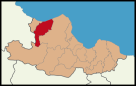
 Map showing Alaçam District in Samsun Province | |
| Coordinates: 41°36′36″N 35°35′42″E / 41.61000°N 35.59500°E | |
| Country | Turkey |
| Province | Samsun |
| Government | |
| • Mayor | İlyas Acar (MHP) |
| Area | 598 km2 (231 sq mi) |
| Population (2022)[1] | 24,647 |
| • Density | 41/km2 (110/sq mi) |
| Time zone | UTC+3 (TRT) |
| Postal code | 55800 |
| Area code | 0362 |
| Climate | Cfa |
| Website | www |
Alaçam is a municipality and district of Samsun Province, Turkey.[2] Its area is 598 km2,[3] and its population is 24,647 (2022).[1] Scholars believe that Alaçam is the site of the ancient city of Zaliche or Zaliches.[4]
History
Alaçam has a long history. It has been held by
The
Economy
Alaçam County's economy relies mainly on agriculture and animal husbandry. Like most of the region Tobacco is the leading agricultural product. In addition to this wheat, rice, corn and nuts production will follow. It also has some raising fruits and vegetables. being on the Black Sea coast fishing is also done. In animal husbandry and livestock farming is carried out. Approximately 6200 farmers engaged in tobacco farming.
Composition
There are 65
- Akbulut
- Akgüney
- Alidedebölmesi
- Alpaslan
- Aşağıakgüney
- Aşağıısırganlı
- Aşağıkoçlu
- Bahşioymağı
- Bekiroğlu
- Çeşme
- Demircideresi
- Doğankent
- Doyran
- Esentepe
- Etyemez
- Fatih
- Göçkün
- Gökçeağaçoymağı
- Gökçeboğaz
- Gülkaya
- Gültepe
- Gümüşova
- Güvenli
- Habilli
- Harmancık
- İncirli
- Kadıköy
- Kalıkdemirci
- Kapaklı
- Karaçukur
- Karahüseyinli
- Karlı
- Karşıyaka
- Killik
- Kışlakonak
- Kızlan
- Köseköy
- Madenler
- Örenli
- Ortaköy
- Pelitbükü
- Pelitbüküsekicek
- Sancar
- Sarılık
- Şirinköy
- Soğukçam
- Taşkelik
- Tefekli
- Tepebölmesi
- Terskırık
- Toplu
- Umutlu
- Uzunkıraç
- Vicikler
- Yakacık
- Yenicami
- Yenice
- Yeniköy
- Yeşilköy
- Yoğunpelit
- Yukarıelma
- Yukarıısırganlı
- Yukarıkoçlu
- Yukarısoğukçam
- Zeytinköy
Attractions
In the south of the town at an altitude of 1,500 m is the Dürtmen Yaylası Plateau, which is also a recreational area. A portion of the Kızılırmak River delta is within the boundaries of the district.
On May 6 the Hidirellez Festival are held annually. This festival sees national amateur
References
- ^ TÜİK. Retrieved 12 July 2023.
- ^ Büyükşehir İlçe Belediyesi, Turkey Civil Administration Departments Inventory. Retrieved 12 July 2023.
- ^ "İl ve İlçe Yüz ölçümleri". General Directorate of Mapping. Retrieved 12 July 2023.
- ISBN 0-691-03169-X), Map 87 & notes.
- ^ Mahalle, Turkey Civil Administration Departments Inventory. Retrieved 12 July 2023.

