
Allegheny Center
Allegheny Center | |
|---|---|
better source needed ] | |
| • Total | 933 |
| • Density | 4,400/sq mi (1,700/km2) |
Allegheny Center is a
History
In 1783, the
Because Allegheny City was intended by the Pennsylvania Legislature to serve as the county seat of Allegheny County, the central blocks of Redick's 36-block plan were designed for public uses, including a market house and post office. The main thoroughfare was East Ohio Street, which stretched from Allegheny West through Allegheny Center and then to Allegheny East and beyond.
From the 19th century to 1907, Allegheny Center was thus the hub of downtown
After 1907 (when Pittsburgh annexed Allegheny City), this area continued to be a hub for those residents of what was now Pittsburgh's North Side. But the area deteriorated as: 1) Allegheny's wealthiest residents, who had founded Allegheny Country Club in 1895, moved the club to Sewickley in 1902 and began moving their residences along with it; 2) the Great Depression caused an economic slowdown; and 3) rationing during World War II prevented much investment in the buildings. As one example of the trend, the landmark Boggs & Buhl department store, which had done a thriving business among Allegheny City's wealthy residents, steadily lost money after 1931 and was closed in 1958.[5]
In the 1950s, community leaders discussed how to revitalize the historic hub of Allegheny City and established a modern plan for Allegheny Center. Designed by architects Deeter & Ritchey, it involved a $65 million project by Alcoa Properties, Inc. The construction project razed about 518 buildings (including the Boggs & Buhl department store) - many of them taken by eminent domain - to make way for 2 professional buildings, 4 apartment complexes totaling 840 units, 50 townhouses, a shopping mall, and a 3-acre (12,000 m2) public square. The public square was the object of an international design competition sponsored by the Pittsburgh Urban Redevelopment Authority. The entire Allegheny Redevelopment Area encompasses approximately 79 acres (320,000 m2) on the North Side, about a half-mile from downtown Pittsburgh.
The project converted what had been an open, walkable business district into an enclosed mall called Allegheny Center Mall that had few pedestrian entrances and sat above an underground parking garage. The central portion of East Ohio Street was closed, and drivers were forced to take a new ring road around the mall and the other blocks of Redick's initial plan to proceed east or west.

The mall, opened in 1965 and anchored by Sears, F. W. Woolworth Company, and Zayre, had some initial success, but it did not revive the business fortunes of Allegheny City, which continued to decline after Interstate 279 allowed area residents to drive to the northern suburbs to shop.[6][7]
The mall's stores began closing in the 1990s, and the mall gradually became a successful office complex.[8]
Today,[
| Census | Pop. | Note | %± |
|---|---|---|---|
| 1940 | 4,521 | — | |
| 1950 | 3,862 | −14.6% | |
| 1960 | 2,512 | −35.0% | |
| 1970 | 632 | −74.8% | |
| 1980 | 1,586 | 150.9% | |
| 1990 | 1,262 | −20.4% | |
| 2000 | 886 | −29.8% | |
| 2010 | 933 | 5.3% | |
| [10][11] | |||
Surrounding Pittsburgh neighborhoods
- Allegheny West
- Central Northside
- East Allegheny
- North Shore
See also
Gallery
-
 Allegheny Commons Park West Park, dating to 1867.
 -
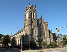 St. Peter's Roman Catholic Church, built in 1874, at 720 Arch Street.
 -
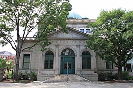 Former Allegheny Post Office (now part of the Children's Museum of Pittsburgh), built in 1897, at 10 Children's Way.
 -
 Allegheny High School, built in 1904, at 810 Arch Street.
 -
 Buhl Planetarium and Institute of Popular Science (now part of the Children's Museum of Pittsburgh), built in 1939, at 10 Children's Way.
 -
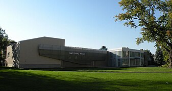 The National Aviary, founded in 1952, at 700 Arch Street.
 -
 Buhl Planetarium postcard c. 1930s


.jpg)
References
- ^ "Census: Pittsburgh" (PDF). Pittsburgh Department of City Planning. January 2006. Archived from the original (PDF) on August 10, 2007. Retrieved 2007-07-19.
- ^ "Census: Pittsburgh". Pittsburgh Department of City Planning. April 2013. Retrieved 2013-04-26.
- ^ "Dutchtown Historic District". Living Places. Gombach Group. Retrieved 3 November 2011.
- ^ "The Next Page: Reviving the North Side's "Lost City"". Pittsburgh Post-Gazette. April 8, 2007. Retrieved 3 November 2011.
- ^ "Boggs & Buhl Department Store, once a North Side institution". Pittsburgh Senior News. December 2004. Retrieved 3 November 2011.
- ^ Canning, John (5 October 2010). "Allegheny Center: a long history of redevelopment". Northside Chronicle. Archived from the original on 15 March 2012. Retrieved 3 November 2011.
- ^ "Allegheny Center Mall: Pittsburgh, PA".
- ^ Spatter, Sam (December 28, 2010). "Former Allegheny Center Mall successful with offices". Pittsburgh Tribune-Review.
- ^ "About Nova Place | Nova Place". novaplace.com. Retrieved 2019-09-25.
- ^ "PGHSNAP - Neighborhoods: All Raw Data".
- ^ "Census:Pittsburgh" (PDF). Archived from the original (PDF) on August 10, 2007. Retrieved 2 September 2012.
- Toker, Franklin (1994) [1986]. Pittsburgh: An Urban Portrait. Pittsburgh: University of Pittsburgh Press. ISBN 0-8229-5434-6.