
Troy Hill (Pittsburgh)
Troy Hill | |
|---|---|
better source needed] | |
| • Total | 0.46 sq mi (1.2 km2) |
| Population (2010)[1] | |
| • Total | 2,714 |
| • Density | 5,900/sq mi (2,300/km2) |
| ZIP Code | 15212 |
Troy Hill is a
. It has a zip code of 15212, and has representation on Pittsburgh City Council by the council member for District 1.Troy Hill sits on a plateau above the
History
Troy Hill was originally part of the Reserve Tract laid out by surveyor and
Troy Hill is home to six historic landmarks: the Troy Hill Firehouse,
In the 1830s, Troy Hill's population escalated significantly, resulting in the need of a school. In 1836, a 1-room brick school house was built in "New Troy" and named Mount Troy School #1, because at the time it was located in Reserve Township. It was sold in 1860, which then was replaced by a new, 2 room brick school house. A decade after the civil war, the pupils increased to around 200, so 2 more rooms were added in 1874. Troy Hill was now part of Allegheny's School System, and in 1883 the school was demolished and a new one was built in its place. That building was then also replaced by the Troy Hill School of 1907, but then was shut down in 1960 and demolished. The site of the original school is now a community park.[2]
Troy Hill was the home to Commissioner Thomas J. Foerster who served 10 years in the state house and 28 years as the Commissioner of Allegheny County. He also served on the first county council established in 2000. Another notable resident was Andrew (Huck) Fenrich who served 9 terms in the state house, was executive secretary for the mayor of Pittsburgh, and also served as executive secretary for the Allegheny County Democrats.
Until 1959 the neighborhood was served by the 4 Troy Hill trolley operated by Pittsburgh Railways.[3]
Beginning in 2013, Evan Mirapaul, an art collector living in Troy Hill, commissioned two whole-house installations in the neighborhood. Both La Hutte Royal, created by German artist Thorsten Brinkmann, and Kunzhaus, by Polish artist Robert Kusmirowski, are free to tour by appointment.[4]
| Year | Pop. | ±% |
|---|---|---|
| 1940 | 7,319 | — |
| 1950 | 6,530 | −10.8% |
| 1960 | 5,141 | −21.3% |
| 1970 | 4,205 | −18.2% |
| 1980 | 3,251 | −22.7% |
| 1990 | 2,742 | −15.7% |
| 2000 | 2,540 | −7.4% |
| 2010 | 2,714 | +6.9% |
| Source: PGHSNAP Census Data[5] | ||
Other names
While "Troy Hill" generally refers to the historically German neighborhood atop the Troy Hill plateau, the neighborhood's boundaries also encompass the narrow and flat river plain that sits between the plateau and the
and "Bohemian Hill" to the Southwest.Troy Hill in Hollywood Films
Several Hollywood films have scenes filmed in Troy Hill, including Hoffa (1992),[8] Innocent Blood (1992),[8] Striking Distance (1993),[9] and Adventureland (2009).[9]
Surrounding and adjacent neighborhoods
Troy Hill has five borders including the Pittsburgh neighborhoods of
City Steps
The Troy Hill neighborhood has 11 distinct flights of city steps, many of which are open and in a safe condition. In Troy Hill, the Steps of Pittsburgh quickly connect pedestrians to public transportation and the East Ohio Street trail.[10]
Gallery
-
 Pittsburgh, Pennsylvania. Buildings shown here circa 1880.
 -
 Great Stone Wall, Allegheny Reservoir, located by Cowley Spray Park at the Troy Hill Playground, built 1848, the last remnant of the former Allegheny City Reservoir.
 -
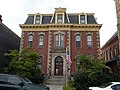 Most Holy Name of Jesus Rectory, built around 1875, at 1700 Harpster Street.
 -
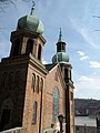
![Saint Anthony's Chapel, built in 1880, at 1700 Harpster Street. About five thousand relics are housed in the chapel, making it the largest collection of relics outside the Vatican.[11][12]](//upload.wikimedia.org/wikipedia/commons/thumb/4/4e/SaintAnthony%27sChapelPittsburghPA.jpg/88px-SaintAnthony%27sChapelPittsburghPA.jpg)
-
 Ober-Guehl House, built around 1877, at 1501 Lowrie Street.
 -
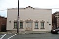 Former Troy Hill Incline Station, built in 1887, at 1733 Lowrie Street.
 -
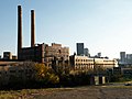 H. J. Heinz Company, in the Troy Hill neighborhood of Pittsburgh, PA, since 1890.
 -
 Route 28
 -
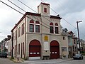 Troy Hill Fire Station#39, built in 1901, at the corner of Ley and Froman Streets. As of 2013, no longer a firehall, but used by the City as home of the Police Bureau's Commercial Vehicle Enforcement division.
 -
 Heinz Lofts, built from 1913 to 1927, at 300 Heinz Street.
 -
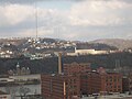 A view of Troy Hill (center) with Spring Hill in the background and The Cork Factory lofts in the Strip District in the foreground.
 -
 The Purse Way city steps are one of many public flights that connect pedestrians to Spring Garden.


![Saint Anthony's Chapel, built in 1880, at 1700 Harpster Street. About five thousand relics are housed in the chapel, making it the largest collection of relics outside the Vatican.[11][12]](/File:SaintAnthony%27sChapelPittsburghPA.jpg)


See also
References
- ^ a b "PGHSNAP 2010 Raw Census Data by Neighborhood". PGHSNAP Utility. Pittsburgh Department of City Planning. 2012. Retrieved 28 June 2013.
- ^ Pfeil, Richard J., Jean E. Koch, Janet M. Koch, and Robert J. Bartolowits. Footprints of Troy Hill. N.p.: n.p., 2012. Print.
- ^ "Pittsburghtransit.com - The Routes - PCC Operation". August 28, 2005. Archived from the original on August 28, 2005. Retrieved August 9, 2009.
- ^ "Post Gazette: Is Art Home?".
- ^ "PGH Snap Data".
- ^ Nelson Jones, Diana (May 20, 2009). "North Side's "Mala Jaska" deteriorates as Route 28 grows". Pittsburgh Post-Gazette. Retrieved 3 November 2011.
- ^ "North Side: East North Side". Bridging the Urban Landscape. Carnegie Library of Pittsburgh. Retrieved 3 November 2011.
- ^ ISSN 0362-4331. Retrieved 2017-03-18.
- ^ a b Cato, Jason. "Where the 'Action!' is: Film crews invade city neighborhoods". TribLIVE.com. Retrieved 2017-03-18.
- ISBN 978-1-4930-1384-5.
- ^ "Anthony's Chapel in Most Holy Name of Jesus Parish". Saints Alive. The International Crusade for Holy Relics. 1998-09-05. Retrieved 2006-09-22.
- ^ Meinzer, Melissa (2007-01-18). "St. Anthony's Chapel". Pittsburgh City Paper. Retrieved 2007-02-27.
External links
- Interactive Pittsburgh Neighborhoods Map
- Troy Hill Citizens, Inc.
- nextpittsburgh.com - Things to do in Troy Hill
| International | |
|---|---|
| National | |