
An-Naqura
An Naqura | |
|---|---|
Village council | |
| • Head of Municipality | Muhammad Hashish |
| Population (2017)[1] | |
| • Total | 1,786 |
| Name meaning | En Nakurah: the horn or trumpet[2] |
An-Naqura (
Location
An Naqura is located 7.57 km northwest of
History
Pottery
Ottoman era
It has been suggested that An-Naqura was the village named Aqbara or Aquira, in the 1596 Ottoman tax records. It had 23 households and 5 bachelors, all Muslim.[7]
In 1667, Anthimus mentions a Christian population in this village, though it had no church.[8]
In 1838 Robinson noted the village as en-Nakurah in the Wady esh-Sha'ir district, west of Nablus.[9][10]
In 1870, Victor Guérin noted it as a village on a hill, with 300 inhabitants, where ancient stones were used in the house-walls.[11]
In 1870/1871 (1288
In 1882, the PEF's Survey of Western Palestine (SWP) described En Nakurah: "A small stone village on the slope of the hill. It has olives, which appear to grow half wild, and a spring of good water, apparently perennial, in the valley to the north, near which are vegetable gardens. A small Mukam stands above the village, on the south."[13]
British Mandate era
In the 1922 census of Palestine conducted by the British Mandate authorities, Nakura had a population of 233 Muslims,[14] increasing in the 1931 census to 247, still all Muslims, in a total of 69 houses.[15]
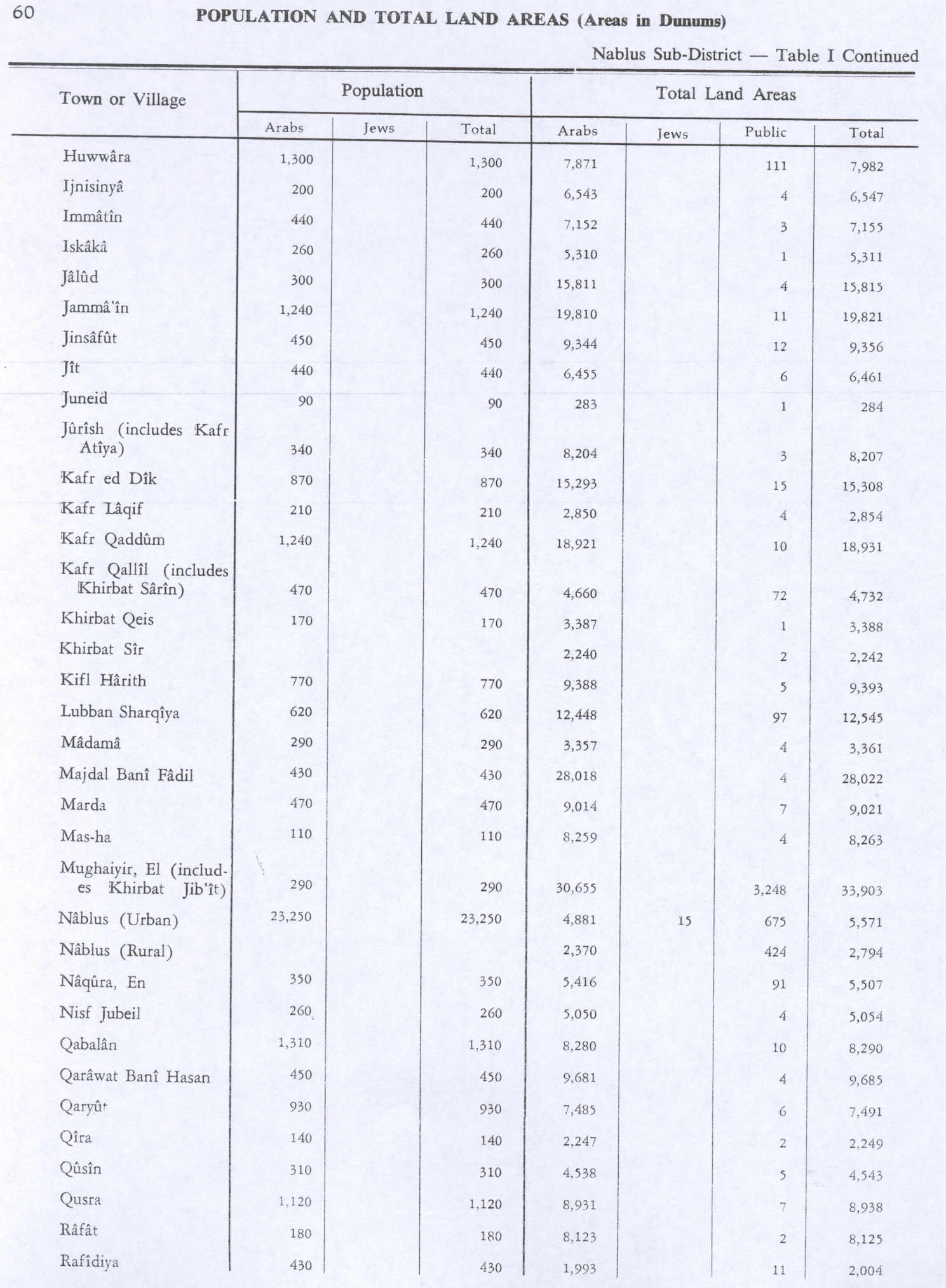
In the 1945 statistics En Naqura had a population of 350 Muslims[16] and a total of 5,507 dunams of land, according to an official land and population survey.[17] Of this, 591 dunams were plantations and irrigable land, 3,444 were used for cereals,[18] while 27 dunams were built-up land.[19]
Jordanian era
In the wake of the 1948 Arab–Israeli War, and after the 1949 Armistice Agreements, An-Naqura came under Jordanian rule.
The Jordanian census of 1961 found 487 inhabitants.[20]
Post-1967
Since the Six-Day War in 1967, An-Naqura has been held under Israeli occupation. A census recorded by the Israeli Civil Administration that same year recorded 610 persons, of whom 37 were refugees from Israel.[21]
After the 1995 accords, 14% of village land was classified as Area A, 51% was classified as Area B, while the remaining 35% was classified as Area C. Israel has “confiscated” 680 dunums of village land for the Israeli settlement of Shavei Shomron.[22]
Demography
Local origins
Some of an-Naqura's inhabitants have origins in Burqa and a few nearby khirbets.[23]
References
- ^ a b Preliminary Results of the Population, Housing and Establishments Census, 2017 (PDF). Palestinian Central Bureau of Statistics (PCBS) (Report). State of Palestine. February 2018. pp. 64–82. Retrieved 2023-10-24.
- ^ Palmer, 1881, p. 188
- ^ 2007 PCBS Census. Palestinian Central Bureau of Statistics. p. 108.
- Jerusalem Media and Communications Center(JMCC).
- ^ An Naqura Village profile, ARIJ, p. 4
- ^ Zertal, 2004, p. 478
- ^ Hütteroth and Abdulfattah, 1977, p. 127; cited in Zertal, 2004, p. 478
- ^ Ellenblum, 2003, p. 248
- ^ Robinson and Smith, 1841, vol 3, Appendix 2, p. 129
- ^ Robinson and Smith, 1841, vol 3, p.138
- ^ Guérin, 1875, p. 186
- ^ Grossman, David (2004). Arab Demography and Early Jewish Settlement in Palestine. Jerusalem: Magnes Press. p. 253.
- ^ Conder and Kitchener, 1882, SWP II, p. 160
- ^ Barron, 1923, Table IX, Sub-district of Nablus, p. 24
- ^ Mills, 1932, p. 63
- ^ Government of Palestine, Department of Statistics, 1945, p. 19
- ^ Government of Palestine, Department of Statistics. Village Statistics, April, 1945. Quoted in Hadawi, 1970, p. 60 Archived 2018-09-06 at the Wayback Machine
- ^ Government of Palestine, Department of Statistics. Village Statistics, April, 1945. Quoted in Hadawi, 1970, p. 107 Archived 2013-10-05 at the Wayback Machine
- ^ Government of Palestine, Department of Statistics. Village Statistics, April, 1945. Quoted in Hadawi, 1970, p. 157 Archived 2013-10-05 at the Wayback Machine
- ^ Government of Jordan, Department of Statistics, 1964, p. 26
- ^ Perlmann, Vol 1, Tab 2: Naqura.
- ^ An Naqura Village profile, ARIJ, p. 15
- ^ Grossman, D. (1986). "Oscillations in the Rural Settlement of Samaria and Judaea in the Ottoman Period". in Shomron studies. Dar, S., Safrai, S., (eds). Tel Aviv: Hakibbutz Hameuchad Publishing House. p. 352
Bibliography
- Barron, J.B., ed. (1923). Palestine: Report and General Abstracts of the Census of 1922. Government of Palestine.
- Conder, C.R.; Kitchener, H.H. (1882). The Survey of Western Palestine: Memoirs of the Topography, Orography, Hydrography, and Archaeology. Vol. 2. London: Committee of the Palestine Exploration Fund.
- Crowfoot, J.W.; Kenyon, K.M.; Sukenik, E.L. (1942). The Buildings at Samaria (Samaria-Sebaste, I). London: Palestine Exploration Fund. pp. 79–81.
- ISBN 9780521521871.
- Government of Jordan, Department of Statistics (1964). First Census of Population and Housing. Volume I: Final Tables; General Characteristics of the Population (PDF).
- Government of Palestine, Department of Statistics (1945). Village Statistics, April, 1945.
- Guérin, V. (1875). Description Géographique Historique et Archéologique de la Palestine (in French). Vol. 2: Samarie, pt. 2. Paris: L'Imprimerie Nationale.
- Hadawi, S. (1970). Village Statistics of 1945: A Classification of Land and Area ownership in Palestine. Palestine Liberation Organization Research Center. Archived from the original on 2018-12-08. Retrieved 2014-09-03.
- Hütteroth, Wolf-Dieter; Abdulfattah, Kamal (1977). Historical Geography of Palestine, Transjordan and Southern Syria in the Late 16th Century. Erlanger Geographische Arbeiten, Sonderband 5. Erlangen, Germany: Vorstand der Fränkischen Geographischen Gesellschaft. ISBN 3-920405-41-2.
- Mills, E., ed. (1932). Census of Palestine 1931. Population of Villages, Towns and Administrative Areas. Jerusalem: Government of Palestine.
- Palmer, E.H. (1881). The Survey of Western Palestine: Arabic and English Name Lists Collected During the Survey by Lieutenants Conder and Kitchener, R. E. Transliterated and Explained by E.H. Palmer. Committee of the Palestine Exploration Fund.
- Perlmann, Joel: The 1967 Census of the West Bank and Gaza Strip: A Digitized Version. Annandale-on-Hudson, N.Y.: Levy Economics Institute of Bard College. November 2011 – February 2012. [Digitized from: Israel Central Bureau of Statistics, Census of Population and Housing, 1967 Conducted in the Areas Administered by the IDF, Vols. 1–5 (1967–70), and Census of Population and Housing: East Jerusalem, Parts 1 and 2 (1968–70).]
- Robinson, E.; Smith, E. (1841). Biblical Researches in Palestine, Mount Sinai and Arabia Petraea: A Journal of Travels in the year 1838. Vol. 3. Boston: Crocker & Brewster.
- ISBN 9004137564.
External links
- Welcome To al-Naqura
- Survey of Western Palestine, Map 11: IAA, Wikimedia commons
- An Naqura Village profile, Applied Research Institute–Jerusalem (ARIJ)
- al-Naqura, aerial photo, ARIJ
- Development Priorities and Needs in An Naqura, ARIJ
| Authority control databases: National |
|---|