
Babadağ, Denizli
Babadağ | |
|---|---|
District and municipality | |
 | |
 Map showing Babadağ District in Denizli Province | |
 Babadağ Location in Turkey  Babadağ Babadağ (Turkey Aegean) | |
| Coordinates: 37°48′25″N 28°51′22″E / 37.80694°N 28.85611°E | |
| Country | Turkey |
| Province | Denizli |
| Government | |
| • Mayor | Ali Atlı (CHP) |
| Area | 124 km2 (48 sq mi) |
| Population (2022)[1] | 6,340 |
| • Density | 51/km2 (130/sq mi) |
| Time zone | UTC+3 (TRT) |
| Postal code | 20480 |
| Area code | 0258 |
| Website | www |
Babadağ, formerly Kadıköy, is a municipality and district of Denizli Province, Turkey.[2] Its area is 124 km2,[3] and its population is 6,340 (2022).[1] It is a highland town, reached by a steep, winding road uphill from the town of Sarayköy. It was known in antiquity as Salbacos.
Agriculture is hard on this mountainside and thus the people have been making a living from stitching clothing in Babadağ for a long time, and others have migrated to Denizli, İzmir and Istanbul. Thus this is the hometown of many of Denizli's successful traders and textile entrepreneurs. Babadağ dollar is Denizli slang for the expression my word is my bond. There are still active workshops in the town, which is also a popular mountain summer holiday location.
The area is characterized by the existence of geological fault zones,[4] which have contributed in the past to the occurrence of many landslides.[5] There was also a high risk of landslides in town, which led the government to evacuate Gündoğdu, a steeply sloped urban district of Babadağ, in 2006. The homes of about 2000 persons were destroyed to prevent uncontrolled return of their former inhabitants, many of whom relocated to newly built houses in the provincial capital Denizli.[6]
In 2019, a large wind park was built on the mountain crest southwest of Babadağ. The towers are visible from many locations in town. The wind park runs along the border between the provinces Denizli und Aydın and is known as Denizli Wind Power Plant. It consists of 22 wind turbines with a total installed power of 74.8 MW. The project was co-financed by the European Bank for Reconstruction and Development.[7] The plant was built by Siemens Gamesa and went on the power grid in 2019/2020. It is operated by the Turkish company Akfen Renewable Energy as part of Akfen Holding.[8][9]
Composition
There are 12
- Ahıllı
- Bekirler
- Cumhuriyet
- Demirli
- Gazi
- Gündoğdu
- İncirpınar
- Kelleci
- Kıranyer
- Mollaahmetler
- Oğuzlar
- Yeniköy
Notable natives
- Hacı Mehmet Zorlu (1919 in Babadağ, Denizli – 7. Mai 2005 in Istanbul), originally a weaver, later founder of a company dealing in textiles, from which the conglomerate Zorlu Holding developed, one of the largest industry enterprises in Turkey.[11]
- Ahmet Nazif Zorlu (* 1944), son of Mehmet Zorlu, in 2021 Chairman of the Board of Zorlu Holding.[12]
- Zeki Zorlu (* 1939), son of Mehmet Zorlu, in 2021 Vice Chairman of Zorlu Holding.[12]
Gallery
-
 Babadağ from the north (picture taken in 2021 on Babadağ Sarayköy Yolu). On the mountain crest in the background, one sees the towers of the wind park.
 -
 Eastern slope of the gorge in the north of Babadağ (picture taken at the cemetery which is located at the northern entrance to town)
 -
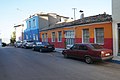 Houses in Mehmet Özer Cd. in the northern central district of town (2021)
 -
 Ward on Istiklal Cd. on the southeastern end of Babadağ (2021)
 -
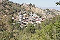
 The evacuated region of Gündoğdu (central eastern part of town, 2021)
 -
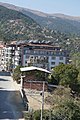 New houses on Hacı Mehmet Zorlu Cd. in the southwest part of town (2021) to which several of the evacuated families relocated from Denizli.


References
- ^ TÜİK. Retrieved 12 July 2023.
- ^ Büyükşehir İlçe Belediyesi, Turkey Civil Administration Departments Inventory. Retrieved 12 July 2023.
- ^ "İl ve İlçe Yüz ölçümleri". General Directorate of Mapping. Retrieved 12 July 2023.
- ^ Ozdemir, Esra Burcu (2005). Structural Evolution of the Babadag Fault Zone in Denizli Graben, South Western Turkey (PDF). Master Thesis, Graduate College, Oklahoma State University.
{{cite book}}: CS1 maint: location missing publisher (link) - .
- ISBN 978-3-319-18406-7.
- ^ "Denizli Wind Power Plant" (PDF). European Bank for Reconstruction and Development.
- ^ "Renewable energy". Akfen Corporation.
- ^ "Akfen energy to invest TL 1.6B in wind power". Daily Sabah. 2018-03-24.
- ^ Mahalle, Turkey Civil Administration Departments Inventory. Retrieved 12 July 2023.
- ^ "Our Founder". Zorlu Corporation.
- ^ a b "Zorlu Holding Board of Management". Zorlu Corporation.