Barabash (rural locality)
Barabash
Барабаш | |
|---|---|
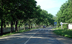
 A street in Barabash | |
| Postal code(s)[4] | |
| OKTMO ID | 05648402101 |
Barabash (Russian: Барабаш) is a rural locality (village), the administrative center of the Barabashsky Rural Settlement, part of the Khasansky District in Primorsky Krai

History
Barabash was founded in 1884, named after Yakov Barabash, who was then chairman of a commission on the delineation of the Russo-Chinese border. In 1937, Barabashky District was created with its center in the village, but on 7 May 1947 was replaced by Khasansky District when the district center moved to Khasan.[1]
From 1955 until 2012,[5] Barabash was the location of the headquarters of the 17th Guards Rifle Division and its successor formations.[6]
Demographics
| Year | Pop. | ±% |
|---|---|---|
2010 | 5,691[2] | +54.2% |
According to the
Russian Census of 2002, it had 3,691 inhabitants, including 2,023 men (54.8%) and 1,668 women (45.2%).[8]
Notable people
- Viktor Suvorov, writer and defector[9]
- Oleg Belokonev, Belarusian general and military leader
References
Citations
- ^ a b c "История села Барабаш". khasan-district.narod.ru. Retrieved 2017-10-11.
- ^ a b c Russian Federal State Statistics Service (2011). Всероссийская перепись населения 2010 года. Том 1 [2010 All-Russian Population Census, vol. 1]. Всероссийская перепись населения 2010 года [2010 All-Russia Population Census] (in Russian). Federal State Statistics Service.
- ^ "Об исчислении времени". Официальный интернет-портал правовой информации (in Russian). 3 June 2011. Retrieved 19 January 2019.
- ^ Почта России. Информационно-вычислительный центр ОАСУ РПО. (Russian Post). Поиск объектов почтовой связи (Postal Objects Search) (in Russian)
- ^ Надпись "УВВАКУ" заменили на имя 70 мотострелковой бригады в Уссурийске [The inscription "UVVAKU" was replaced with the name of the 70 Motor Rifle Brigade in Ussuriysk]. ussur.net (in Russian). Retrieved 2016-03-19.
- ^ Feskov et al 2013, p. 151.
- ^ Всесоюзная перепись населения 1939 года. Численность сельского населения СССР по районам, крупным селам и сельским населённым пунктам - районным центрам [All-Union Population Census of 1939: Rural Population of the Soviet Union in districts, large villages, and rural settlements (district centers)] (in Russian). Institute of Demography at the National Research University: Higher School of Economics. 1939. Retrieved 21 June 2018.
- ^ a b Federal State Statistics Service (21 May 2004). Численность населения России, субъектов Российской Федерации в составе федеральных округов, районов, городских поселений, сельских населённых пунктов – районных центров и сельских населённых пунктов с населением 3 тысячи и более человек [Population of Russia, Its Federal Districts, Federal Subjects, Districts, Urban Localities, Rural Localities—Administrative Centers, and Rural Localities with Population of Over 3,000] (XLS). Всероссийская перепись населения 2002 года [All-Russia Population Census of 2002] (in Russian).
- ^ БИОГРАФИЯ [Biography] (in Russian). Viktor Suvorov. Archived from the original on 27 June 2013. Retrieved 21 June 2018.
Bibliography
- Feskov, V.I.; Golikov, V.I.; Kalashnikov, K.A.; Slugin, S.A. (2013). Вооруженные силы СССР после Второй Мировой войны: от Красной Армии к Советской [The Armed Forces of the USSR after World War II: From the Red Army to the Soviet: Part 1 Land Forces] (in Russian). Tomsk: Scientific and Technical Literature Publishing. ISBN 9785895035306.

