
Beaulieu-sur-Dordogne
Beaulieu-sur-Dordogne | |
|---|---|
 Beaulieu-sur-Dordogne in 2010 | |
.svg) Coat of arms | |
Location of Beaulieu-sur-Dordogne  | |
 Beaulieu-sur-Dordogne  Beaulieu-sur-Dordogne | |
| Coordinates: 44°58′45″N 1°50′21″E / 44.9792°N 1.8392°E | |
| Country | France |
| Region | Nouvelle-Aquitaine |
| Department | Corrèze |
| Arrondissement | Brive-la-Gaillarde |
| Canton | Midi Corrézien |
| Intercommunality | Midi Corrézien |
| Government | |
| • Mayor (2020–2026) | Dominique Cayre[1] |
| Area 1 | 16.89 km2 (6.52 sq mi) |
| Population (2021)[2] | 1,300 |
| • Density | 77/km2 (200/sq mi) |
| Time zone | UTC+01:00 (CET) |
| • Summer (DST) | UTC+02:00 (CEST) |
| INSEE/Postal code | 19019 /19120 |
| Elevation | 125–432 m (410–1,417 ft) |
| 1 French Land Register data, which excludes lakes, ponds, glaciers > 1 km2 (0.386 sq mi or 247 acres) and river estuaries. | |
Beaulieu-sur-Dordogne (French pronunciation: [boljø syʁ dɔʁdɔɲ], literally Beaulieu on Dordogne; Occitan: Belluec) is a commune in the Corrèze department in the Nouvelle-Aquitaine region, central France. Beaulieu is a medieval city, originally dominated by its great abbey of St Pierre, of which only the abbey church remains. On 1 January 2019, the former commune Brivezac was merged into Beaulieu-sur-Dordogne.[3]
Geography

Toponymy
Beaulieu comes from the Latin "bellus locus", "lieu beau", a nice place to live. The inhabitants of Beaulieu are called by varies names: Beaulieusard, Beaulieurois, Bellilocien, Bellieurain, Bellilocois, Belliloquois, Belliloqueteux, Belliquière, Berlugan, Beloudonien.
Location
Beaulieu is in the south of the Corrèze department. It is located on the D940 road on the banks of the Dordogne river, south of the Limousin. Tulle is 37 km north. Brive-la-Gaillarde is 38 km away and Collonges-la-Rouge is 20 km to the northwest. Aurillac (Cantal) is 60 km to the east.
Hydrography and relief
The commune is limited on its entire eastern border by the Dordogne, and watered to the north by its tributary the Ménoire.
History
Middle ages

In the midst of the
Thanks to the pious donations of the Counts of Quercy, the Viscounts of
The powerful abbey, under the protection of popular saints, was located around fertile lands, an indispensable condition for the village inhabitants to develop. From the end of the 12th century, a village was built around the
From 1213, saw the end of the Cluny stranglehold, with the abbey losing power little by little. Beaulieu became the seat of the conflicts for power between the Lord Abbot, the middle-class and the Viscount of Turenne. With the beginning of the fifteenth century, the abbey gradually crumbled.
Modern era

The abbey declined during the Hundred Years' War, which devastated the region. The French Wars of Religion completed the process. The abbey suffered the attacks by the Protestants during that war. As the sixteenth century approached, the ideas of the reform had spread under the influence of the merchants and gabariers (barge-men) of the Dordogne. Twice (1569–1574), the Protestants troops of the Admiral Gaspard de Coligny plundered the city and the abbey. The abbey church was then transformed into a Protestant temple. Given to the Catholic cult, in 1622, thanks to the Catholic League, the abbey was rebuilt in the seventeenth century by the Benedictine Congregation of Saint-Maur. They reinstate the monastic discipline and it was not until 1663 that the abbey began to function again. The city, again prosperous, erected its opulent mansions. The former Leaguer's created, with the help of the bishops, many brotherhoods.
French Revolution and Empire
The abbey still sheltered six monks when the
Contemporary period
On 1 January 2019 the municipality extended its perimeter to that of Brivezac.
Population and society
Population
| Year | Pop. | ±% |
|---|---|---|
| 1962 | 1,511 | — |
| 1968 | 1,592 | +5.4% |
| 1975 | 1,560 | −2.0% |
| 1982 | 1,508 | −3.3% |
| 1990 | 1,265 | −16.1% |
| 1999 | 1,278 | +1.0% |
| 2008 | 1,296 | +1.4% |
| 2015 | 1,174 | −9.4% |
Sport
Beaulieu's rugby club was created in 1908: Union Sportive Beaulieu (U.S.B.). A regular champion of the Limousin, the club participated in several stages of the French championship reaching the semifinals in 1921. During the 2011-2012 season, the club was shown by winning the title of Champion of France in 2nd Series by beating in the final, US Josbaig Saint Goin (15 to 11), crowning a great season and allowing the club to climb in 1st Series for the season 2012-2013.
Economy
The Beaulieu region produces 400 tonnes of strawberries or nearly 1% of French production. In particular, it feeds the production of jams by the Andros group in its factories in Biars-Bretenoux. A strawberry festival is held on the second Sunday in May, where a strawberry pie is made of 8 metres diameter and 900 kg of strawberries.

Local culture and heritage
Civil buildings

Château d'Estresse
The Chateau was built on a terrace supported by a medieval retaining wall on the Dordogne river, so as to defend Beaulieu and the upper valley from invasions from the river (King Odo of France stopped the Normans in 889). The Chateau consists of buildings from the 14th, 15th and 16th centuries, and one can still see a bretèche protruding over the entrance gate. The Chateau approached the twentieth century in the state of ruin, but it was restored. It is included in the inventory of historical monuments.
Religious buildings

Abbey Church of St Pierre
Founded in the 9th century by Rodolphe of the family of the Counts of Turenne, Lords of Beaulieu, the abbey was attached to
In 1150, the
The church has a nave of four spans. The choir, the southern arm of the transept and much of the nave date back to the original Romanesque phase of the building. The belfry and the central tower are of later, Gothic construction. The total length of the building is 71 metres, and the width at the transept is 38 metres. The nave rises to 17 metres, while the central tower exceeds it by 6 metres.
The most notable feature of the church is the elaborately sculpted south portal, particularly the
Another notable feature is a fine
Cultural heritage
In its 2017 charts, le Conseil national des villes et villages fleuris de France (National Council of the Flower Towns and Villages of France) awarded a flower to the commune in the Concours des villes et villages fleuris (Contest of the Flowers towns and villages).

Personalities
Notable personalities linked to the commune include:
- Eustorg de Beaulieu (1495–1552), French poet, composer and pastor
- Jean-Antoine Marbot (1754–1800), French general and politician, father of generals Adolphe and Marcellin Marbot
- Adolphe Marbot (1781–1844), French general
- Marcellin Marbot (1782–1854), French general, author of the famous Memoirs of General Marbot
- Frits Thaulow (1847–1906), Norwegian Impressionist painter
- Asher Peres (1934–2005), Israeli physicist
Gallery
-
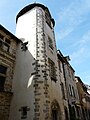
 The belfry of the abbey church in Beaulieu-sur-Dordogne.
 -
 Southern portal of the abbey church.
 -
 Maison Clare entrance.
 -
 Sévigné institution building window detail.
 -
 Chapelle des pénitents on the bank of the Dordogne river.
 -
 15th century house, Place de la Bridolle.
 -
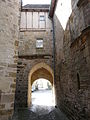 Interior view of the Ste Catherine gate.
 -
 Abadiol mill.
 -
 Nave of the St Pierre abbey church.
 -
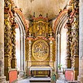 Assumption of the Virgin Mary retablein the St Pierre abbey church.
 -
 The return and triumph of Christ, depicted on the southern portal tympanum of the St Pierre abbey church.
 -
 Maison Calary tower.
 -
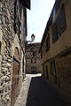 View of a house on Place de la Bridolle.
 -
 Dordogne riverbank.


_Place_de_la_Bridolle_-_Maison_du_XVe_si%C3%A8cle.jpg)
.JPG)


_Abbatiale_Portail_M%C3%A9ridional_Tympan_08.jpg)


See also
References
- ^ "Répertoire national des élus: les maires" (in French). data.gouv.fr, Plateforme ouverte des données publiques françaises. 13 September 2022.
- ^ "Populations légales 2021". The National Institute of Statistics and Economic Studies. 28 December 2023.
- ^ Arrêté préfectoral 28 June 2018 (in French)
- ^ ISBN 978-2-7377-0403-1.