
Berlin Brandenburger Tor station
Berlin Brandenburger Tor DS100 code | BUDL | ||||||||||||||||||||||||||||||||||
|---|---|---|---|---|---|---|---|---|---|---|---|---|---|---|---|---|---|---|---|---|---|---|---|---|---|---|---|---|---|---|---|---|---|---|---|
| Category | 4 | ||||||||||||||||||||||||||||||||||
| Fare zone | VBB: Berlin A/5555[1] | ||||||||||||||||||||||||||||||||||
| History | |||||||||||||||||||||||||||||||||||
| Opened | 27 July 1936 (First opening) 2 December 1946 (Second opening) 1 September 1990 (Third opening) | ||||||||||||||||||||||||||||||||||
| Closed | 21 April 1945 (First closing) 13 August 1961 (Second closing) | ||||||||||||||||||||||||||||||||||
| Previous names | Berlin Unter den Linden | ||||||||||||||||||||||||||||||||||
| Services | |||||||||||||||||||||||||||||||||||
| |||||||||||||||||||||||||||||||||||
 | |||||||||||||||||||||||||||||||||||


Berlin Brandenburger Tor station (
railway station in the central Mitte district of Berlin, Germany, located on the Unter den Linden boulevard near Hotel Adlon, Pariser Platz and Brandenburg Gate. It is served by the Berlin S-Bahn and U-Bahn
, as well as local bus lines. The station was known as Berlin Unter den Linden from 1936–2009.
Overview

The station opened on 27 July 1936 in the course of the building of the
Nord-Süd Bahn tunnel. Train service discontinued on 21 April 1945 and could not be resumed until 2 December 1946 as the tunnel was flooded. The station was again closed with the construction of the Berlin Wall on 13 August 1961 and for decades became one of Berlin's ghost stations, as while both terminals of the Nord-Süd railway line were located in West Berlin, the station itself was located in the East. Unter den Linden later reopened on 1 September 1990, following the German reunification
.
On completion of the new U55 line of the Berlin U-Bahn from Berlin Hauptbahnhof, the U-bahn station started operations as its temporary southern terminus and as an interchange with the Nord Süd S-Bahn lines. Both the U-Bahn and the S-Bahn station were renamed Brandenburger Tor in 2009 to distinguish them from Unter den Linden U-Bahn station at the junction of Unter den Linden with the Friedrichstraße.[2] The U5 line through the station to the east opened on 4 December 2020.
Gallery
-
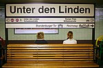 Unter den Linden station sign in 2007
 -
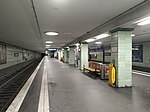 View of the S-Bahn station
 -
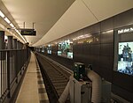
 Platform of the U-Bahn station (U5)
 -
 U-Bahn station - empty track to Alexanderplatz (December 2011)
 -
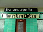 Signboards with new and old station names (S-Bahn)
_SBahn.jpg)


.jpg)
See also
References
- ^ "Der VBB-Tarif: Aufteilung des Verbundgebietes in Tarifwaben und Tarifbereiche" (PDF). Verkehrsbetrieb Potsdam. Verkehrsverbund Berlin-Brandenburg. 1 January 2017. Archived from the original (PDF) on 27 October 2020. Retrieved 25 November 2019.
- ^ PDF Map of Brandenburger Tor station (BVG official website)
External links
Wikimedia Commons has media related to Bahnhof Berlin Brandenburger Tor.
- Station information (in German)
| International | |
|---|---|
| Other | |