
Bonanza Peak (Alaska)
| Bonanza Peak | |
|---|---|
 South aspect of Bonanza Peak | |
| Highest point | |
| Elevation | 6,983 ft (2,128 m)[1] |
| Prominence | 1,583 ft (482 m)[1] |
| Parent peak | Peak 12454 |
| Isolation | 4.94 mi (7.95 km)[2] |
| Coordinates | 61°31′14″N 142°50′06″W / 61.5205763°N 142.8350518°W[3] |
| Geography | |
 Bonanza Peak Location of Bonanza Peak in Alaska | |
| Location | |
| Parent range | Wrangell Mountains |
| Topo map | USGS McCarthy C-5 |
| Geology | |
| Type of rock | Limestone, Greenstone |
Bonanza Peak is a 6,983-foot (2,128 meter) mountain summit located in the
History
Bonanza Peak hosted five mines: Bonanza, Jumbo, Mother Lode, Erie, and Glacier. The Bonanza ore body was discovered August 1900 by
Present-day visitors may hike to the abandoned Bonanza, Jumbo, and Erie mines, all of which are strenuous full-day hikes, with Erie Mine being a somewhat terrifying scramble along cliffs overlooking the Stairway Icefall.
Geology
Bonanza Peak is part of the
Climate
Based on the Köppen climate classification, Bonanza Peak is located in a subarctic climate zone with long, cold, snowy winters, and cool summers.[8] Weather systems coming off the Gulf of Alaska are forced upwards by the Wrangell Mountains (orographic lift), causing heavy precipitation in the form of rainfall and snowfall. Temperatures can drop below −20 °C with wind chill factors below −30 °C. The months May through June offer the most favorable weather for viewing and climbing.
Gallery
-
 Kennecott Mill site with Bonanza Peak
 -
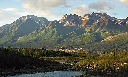 Bonanza Peak and Kennecott
 -
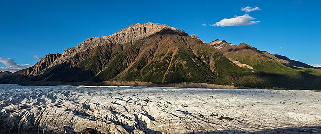 West aspect of Bonanza across Root Glacier
 -
 Jumbo Mine ruins in bullseye, summit in upper right.
 -
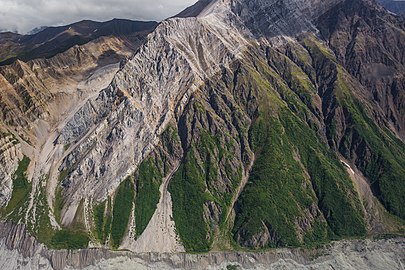 Erie Mine ruins in bullseye at contact line of limestone overlaying greenstone
 -
 Erie Mine ruins
 -
 Old route to the Bonanza Mine


See also
References
- ^ a b "Bonanza Peak, Alaska". Peakbagger.com. Retrieved 2020-02-14.
- ^ Bonanza Peak, listsofjohn.com
- ^ a b "Bonanza Peak". Geographic Names Information System. United States Geological Survey, United States Department of the Interior. Retrieved 2020-02-14.
- ^ a b Fred H. Moffit; Stephen R. Capps (1911). Geology and Mineral Resources of the Nizina District, Alaska, USGS Bulletin 448. U.S. Government Printing Office. p. 76.
- ^ a b Charles Caldwell Hawley (2014). A Kennecott Story. The University of Utah Press.
- ^ Alfredo O. Quinn (1995). Iron Rails to Alaskan Copper. D'Aloguin Publishing Co. p. 175.
- ^ Geologic Studies in Alaska by the U.S. Geological Survey, 1995. Robert P. Eppinger,Stephen J. Sutley, and John B. McHugh. Page 19-22.
- ISSN 1027-5606.
External links
- Weather forecast: Bonanza Peak
- Wiktionary: Bonanza definition