
Bonnat, Creuse
Bonnat | |
|---|---|
 The church in Bonnat | |
 Coat of arms | |
Location of Bonnat  | |
 Bonnat  Bonnat | |
| Coordinates: 46°19′43″N 1°54′20″E / 46.3286°N 1.9056°E | |
| Country | France |
| Region | Nouvelle-Aquitaine |
| Department | Creuse |
| Arrondissement | Guéret |
| Canton | Bonnat |
| Intercommunality | CC Portes de la Creuse en Marche |
| Government | |
| • Mayor (2020–2026) | Philippe Chavant[1] |
| Area 1 | 45.79 km2 (17.68 sq mi) |
| Population (2021)[2] | 1,352 |
| • Density | 30/km2 (76/sq mi) |
| Time zone | UTC+01:00 (CET) |
| • Summer (DST) | UTC+02:00 (CEST) |
| INSEE/Postal code | 23025 /23220 |
| Elevation | 248–515 m (814–1,690 ft) (avg. 354 m or 1,161 ft) |
| 1 French Land Register data, which excludes lakes, ponds, glaciers > 1 km2 (0.386 sq mi or 247 acres) and river estuaries. | |
Bonnat (French pronunciation: [bɔna]; Occitan: Bònac) is a commune in the Creuse department in the Nouvelle-Aquitaine region in France.
Geography
An area of
farming and some associated light industry, comprising the village and several hamlets situated in the valley of the Petite Creuse
, some 10 miles (16 km) north of Guéret, at the junction of the D6, D15 and the D56.
Miscellany
The commune owns and manages a nearby chateau de Mornay which has its own racing circuit for cars and motorbikes and is used for
corporate functions. It also owns a restaurant
in the town near to the church. A small stream flows by the southern border of the town on which stands a recently renovated lavoir (wash-house).
A recent development of a very large book repository on land owned by the commune has caused some concern locally because of extensive lorry traffic on the narrow rural roads.
Population
| Year | Pop. | ±% |
|---|---|---|
| 1962 | 1,490 | — |
| 1968 | 1,535 | +3.0% |
| 1975 | 1,340 | −12.7% |
| 1982 | 1,348 | +0.6% |
| 1990 | 1,387 | +2.9% |
| 1999 | 1,348 | −2.8% |
| 2008 | 1,304 | −3.3% |
Sights
- The church of St. Sylvain, dating from the thirteenth century.
- An ancient public washhouse.
- Three chateaux.
-
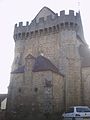 Fortifications of the church
 -
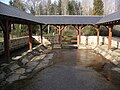 Recently restored Lavoir
 -
 Village square


See also
References
- ^ "Répertoire national des élus: les maires" (in French). data.gouv.fr, Plateforme ouverte des données publiques françaises. 13 September 2022.
- ^ "Populations légales 2021". The National Institute of Statistics and Economic Studies. 28 December 2023.
Wikimedia Commons has media related to Bonnat.
| Authority control databases: National |
|---|