
Bulakan, Bulacan
This article needs additional citations for verification. (October 2013) |
Bulakan
Bulacan | ||
|---|---|---|
| Municipality of Bulakan | ||
 San Jose | ||
 Flag  Seal | ||
| Nickname: First Capital of Bulacan | ||
 Map of Bulacan with Bulakan highlighted | ||
OpenStreetMap  | ||
.svg) Bulakan Location within the Philippines | ||
| Coordinates: 14°47′34″N 120°52′44″E / 14.79278°N 120.87889°E | ||
| Country | Philippines | |
| Region | Central Luzon | |
| Province | Bulacan | |
| District | 1st district | |
Founded | 1572 | |
| Barangays | 14
(see Vice Mayor Reina Rica C. Sanchez | |
| • Representative | Danilo A. Domingo | |
| • Municipal Council | Members | |
| • Roman Catholicism | ||
| Catholic diocese | Malolos | |
Bulakan, officially the Municipality of Bulakan (
It is 35 kilometers (22 mi) north of Manila.
Bulakan, which is one of the oldest towns in the Philippines, became the encomienda or capital of the
With regards to whether to use the letters "c" or "k" to refer to the municipality of Bulakan, the New Provincial Administrative Code of Bulacan (Ordinance no. C-004) of 2007 states on Chapter 2, Section 15 that the word "Bulakan" stands for the municipality and first capital of the province while "Bulacan" refers to the province itself.[5]
Etymology
The town got its name is from the Tagalog word bulak, which means cotton in the English language. It was named Bulakan due to the abundance of cotton plant growing in the region.
History
The
In a census of June 1591, the
In the heart of the town stands the centuries-old adobe church of Our Lady of the Assumption (Nuestra Señora de la Asunción). In front of the church stands the municipal hall and a park named "Plaza del Pilar", which is dedicated to Revolutionary General Gregorio del Pilar who hailed from Barangay San Jose, Bulakan.
The
After 400 long years, changes have been made to the old barrios that consist of the town. Bagio became part of Bagumbayan in 1731, Tibig exist in 1735, Dapdap was renamed Santa Ana in 1741, Nagdasig become part of Tab-Ang in 1744 and now San Francisco, Parian was renamed Santa Inez in 1765, Bulacan (Camino Real), Daan Estacion, Paniqui and Calungusan was created into one barrio and was named San Jose, Barrio Pitpitan occupied Acsajo, Cupang was joined to Maysantor now Maysantol, Banban became Bangbang and now Bambang, Perez exists as separate barrio of Taliktik (now Taliptip), and with the same old name of barrios San Nicolas, Matungao and Balubad.
The early Bulaqueños, the residents of Bulakan, were engaged in farming, fishing and handicrafts, especially weaving.
The town of Bulakan, being the first capital of the province, gave the name to the province as customary to the other provinces of the early Philippines (like
Bulakan was also the scene of battle between the Spaniards led by Simón de Anda y Salazar and the British led by Captain Slay during the short British occupation of Manila. The British sent an expedition of 400 British, 300 Malabar Negroes and 2,000 Chinese allies. The Spaniards, with the natives of Bulacan, made a gallant stand but were defeated. Captain Slay eventually took over the town but did not last long.
A huge group of about 8,000 Filipino guerillas led by Spanish Jose Pedro de Busto made a nine long days battle in front of the church up to the foot bridge against Captain Slay. They made Captain Slay to retreat to Manila. On this fight, Bulaqueños have shown for the first time an extraordinary martyrdom. The British attempt of conquering the rest of the country was gone astray because of the marvelous fight made by Bulakeños. [citation needed]
The Church of Nuestra Señora de la Asuncion is the birthplace of
Geography
The municipality of Bulakan lies in the southwestern part of the province of Bulacan and is surrounded by a number of municipalities. It is bounded to the north by the municipality of Guiguinto, to the south by Manila Bay, to the east by the municipality of Bocaue, to the northwest by the city of Malolos, to the northeast by the municipality of Balagtas, on the southeast by the city of Meycauayan and to the southeast by the municipality of Obando.
It is about 35 kilometres (22 mi) away from the city of Manila. Approximately 72.90 square kilometres (28.15 sq mi) or 2.7284% of the total land area of the entire province. It ranks tenth (10th) in terms of land area among other municipalities in the province.
Barangays
Bulakan is politically subdivided into 14 barangays. Barangays San Jose and Bagumbayan are classified by the
These barangays are headed by elected officials:
| PSGC | Barangay | Population | ±% p.a. | |||
|---|---|---|---|---|---|---|
| 2020[3] | 2010[8] | |||||
| 031405001 | Bagumbayan | 4.6% | 3,701 | 3,279 | 1.22% | |
| 031405002 | Balubad | 4.1% | 3,357 | 3,076 | 0.88% | |
| 031405003 | Bambang | 16.7% | 13,604 | 13,566 | 0.03% | |
| 031405004 | Matungao | 14.3% | 11,646 | 9,699 | 1.85% | |
| 031405005 | Maysantol | 3.4% | 2,768 | 2,712 | 0.20% | |
| 031405006 | Perez | 2.9% | 2,381 | 2,152 | 1.02% | |
| 031405007 | Pitpitan | 5.6% | 4,516 | 4,028 | 1.15% | |
| 031405009 | San Francisco | 7.6% | 6,145 | 5,221 | 1.64% | |
| 031405010 | San Jose (Poblacion) | 4.2% | 3,372 | 3,327 | 0.13% | |
| 031405012 | San Nicolas | 7.1% | 5,804 | 5,282 | 0.95% | |
| 031405013 | Santa Ana | 10.0% | 8,122 | 7,685 | 0.55% | |
| 031405014 | Santa Ines | 3.1% | 2,508 | 2,682 | −0.67% | |
| 031405015 | Taliptip | 6.8% | 5,490 | 6,202 | −1.21% | |
| 031405016 | Tibig | 3.9% | 3,151 | 2,840 | 1.04% | |
| Total | 81,232 | 71,751 | 1.25% | |||
Climate
| Climate data for Bulakan, Bulacan | |||||||||||||
|---|---|---|---|---|---|---|---|---|---|---|---|---|---|
| Month | Jan | Feb | Mar | Apr | May | Jun | Jul | Aug | Sep | Oct | Nov | Dec | Year |
| Mean daily maximum °C (°F) | 29 (84) |
30 (86) |
32 (90) |
34 (93) |
33 (91) |
31 (88) |
30 (86) |
29 (84) |
29 (84) |
30 (86) |
30 (86) |
29 (84) |
31 (87) |
| Mean daily minimum °C (°F) | 19 (66) |
20 (68) |
21 (70) |
23 (73) |
24 (75) |
25 (77) |
24 (75) |
24 (75) |
24 (75) |
23 (73) |
22 (72) |
21 (70) |
23 (72) |
| Average precipitation mm (inches) | 7 (0.3) |
7 (0.3) |
9 (0.4) |
21 (0.8) |
101 (4.0) |
152 (6.0) |
188 (7.4) |
170 (6.7) |
159 (6.3) |
115 (4.5) |
47 (1.9) |
29 (1.1) |
1,005 (39.7) |
| Average rainy days | 3.3 | 3.5 | 11.1 | 8.1 | 18.9 | 23.5 | 26.4 | 25.5 | 24.5 | 19.6 | 10.4 | 6.4 | 181.2 |
| Source: Meteoblue[9] | |||||||||||||
Demographics
| Year | Pop. | ±% p.a. |
|---|---|---|
| 1903 | 11,589 | — |
| 1918 | 10,423 | −0.70% |
| 1939 | 11,931 | +0.65% |
| 1948 | 13,242 | +1.17% |
| 1960 | 18,395 | +2.78% |
| 1970 | 26,750 | +3.81% |
| 1975 | 28,361 | +1.18% |
| 1980 | 34,920 | +4.25% |
| 1990 | 48,770 | +3.40% |
| 1995 | 54,236 | +2.01% |
| 2000 | 62,903 | +3.23% |
| 2007 | 72,289 | +1.94% |
| 2010 | 71,751 | −0.27% |
| 2015 | 76,565 | +1.24% |
| 2020 | 81,232 | +1.17% |
| Source: Philippine Statistics Authority[10][8] | ||
In the 2020 census, the population of Bulakan, was 81,232 people, with a density of 1,100 inhabitants per square kilometre or 2,800 inhabitants per square mile.[3]
In the 2010 census, the Municipality of Bulakan had a total population of 71,751. Barangay Bambang is the most densely populated with 13,566. It is followed by Barangay Matungao and Barangay Santa Ana with 9,699 and 7,685 respectively, on the other hand, the least populated barangay are Barangay Perez and Barangay Santa Ines with 2,152 and 2,682 respectively.[8]
Compared with the Municipality's population in 1995 which was 54,624, it shows an increase of 10,060 persons from 1995 to 2004. An annual growth rate of 1,117 or an average increase of 18.42% in the span of nine years.
The highest percentage changes in population from 1995 to 2004 was exhibited in Barangay Perez, Pitpitan, Santa Ines, Tibig, Bagumbayan with an increase of 56.33%, 54.74%, 39.73%, 34.66%, and 33.46% respectively.
On the other hand, barangays that shows the least percentage change in population are Barangay San Francisco, Matungao, and Bambang with only an increase of 0.4%, 2.95% and 7.57% respectively.
Number of households
The Community Base Monitoring System (CBMS) survey as of January 2005 showed 14,523 household. In comparison with the total number of households of 12,488 in 2002 an increase of 2,035 households from 2002 to 2005 is realized.
Gender and age structure
Like the rest of the country, the population in Bulakan exhibits a pyramidal age structure. The population between the age 0-14 accounts for 18,586 or 35% of the total population. On the other hand, 31,963 or 61% belongs to the 15–64 years old age bracket and only 2,103 or 4% are in the age bracket of 65 years old and above.
In terms of gender distribution, the female population slightly outnumbered the male population by .47% in 2002 Census on Population. There were 31,553 male population as against the 31,702 female population which results to gender ratio of 1 male is to 1.004 female comparatively.
Religion
The
Our Lady of Assumption Parish Church

The town's parish church, the
Language
Generally, the town of Bulakan is a Tagalog speaking town. About 86.8% speak Tagalog while the rest speak Kapampangan.
Literacy rate
The 2005 Community Based Monitoring System Survey shows that the Population of 10 years old and above are around 38,164 persons and about 37,822 have a literacy rate of 99.10 percent.
The 2005 Community Based Monitoring System Survey also shows that there are only 219 licensed professionals here, the lowest in the whole province.
Economy
Graphs are unavailable due to technical issues. There is more info on Phabricator and on MediaWiki.org. |
The New Manila International Airport is being proposed to be built the coastlines of the municipality with target completion of 2025.
Government
Local government

- Mayor: PDP-Laban)
- Vice Mayor: Reina Rica "Aika" C. Sanchez (PDP-Laban)
- Members of the Sangguniang Bayan:
- Aubrhie Cindyrelle D. Carpio (Aksyon)
- Jose Antonio "Tony" V. Lava (Independent)
- Aron Ronald R. Cruz (PDP-Laban)
- Marbin D. Garcia (Aksyon)
- Christopher Aron C. del Rosario (PDP-Laban)
- Bienvinido "Benjo" M. Cruz Jr. (PDP-Laban)
- Ana Marie "Aina" V. Pagsibigan (PDP-Laban)
- Rchie "Archie" E. San Jose (PDP-Laban)
Education
Bulacan State University - Meneses Campus
Bulacan State University - Meneses Campus is a satellite campus of Bulacan State University, situated in Barangay Matungao.
secondary schools
- Public high schools
- Taliptip National High School
- Doña Candeleria Meneses Duque Memorial High School
- San Francisco Xavier High School
- Romeo Acuña Santos Memorial High School
- Private high schools
- Assumpta Academy
- Doña Trinidad Mendoza Institute
- Bulacan Montessori School
- Bulacan Methodist School
- Bulacan Central Christian School
Every barangay has its own day-care for pre-elementary pupils and an elementary school. There are also many private elementary schools situated in different barangays.
Notable personalities
- Vicente Lava - Chemist and General Secretary of the Communist Party of the Philippines (1942-1944)
- Marcelo H. del Pilar - patriot, lawyer, journalist and activist, he was one of the leaders of the Propaganda Movement during the Spanish period and served as the second editor-in-chief of La Solidaridad; more known by his pseudonym "Plaridel", having him the origin of the name of the neighboring town Plaridel, Bulacan
- Gregorio del Pilar - Katipunero nephew of Marcelo H. del Pilar, served as one of the youngest generals of the Philippine Revolution and the First Philippine Republic; known as the "Hero of Battle of Tirad Pass"
- Komisyon ng Wikang Filipino and National Commission for Culture and the Arts.
Gallery
-
 Bulakan Welcome Arch (from Guiguinto)
 -
 Bulakan Wet and Dry Public Market
 -
 Marcelo H. Del Pilar National Shrine
 -
 Gregorio Del Pilar Monument
 -
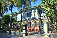 Francisco Soc Rodrigo Ancestral House
 -
 Angkan ni Plaridel Mausoleum
 -
 Museo Del Pilar
 -
 San Isidro Labrador Church, Barangay Bambang
 -
 Santa Maria River beside Bagumbayan Street


See also
References
- (DILG)
- (PDF) from the original on May 25, 2021. Retrieved July 16, 2021.
- ^ a b c d Census of Population (2020). "Region III (Central Luzon)". Total Population by Province, City, Municipality and Barangay. Philippine Statistics Authority. Retrieved July 8, 2021.
- ^ "PSA Releases the 2018 Municipal and City Level Poverty Estimates". Philippine Statistics Authority. December 15, 2021. Retrieved January 22, 2022.
- ^ "New Provincial Administrative Code of Bulacan" (PDF). Retrieved June 3, 2014.
- ^ Administracion espiritual de los Padres Agustinos Calzados de la provincia del dulce Nombre de Jesus, by R. P. Fr. Francisco Villacorta, Imprenta de H. Roldan Valladolid, Mayo 1833 p. 39
- ^ Catalogo de los religiosos de N.P.S. Agustin de la Provincia del Smo Nombre de Jesus de Filipinas, Imp. De Ramirez Y Giraudier, Manila 1864. p. 11
- ^ a b c Census of Population and Housing (2010). "Region III (Central Luzon)" (PDF). Total Population by Province, City, Municipality and Barangay. National Statistics Office. Retrieved June 29, 2016.
- ^ "Bulakan: Average Temperatures and Rainfall". Meteoblue. Retrieved May 12, 2020.
- ^ Census of Population (2015). "Region III (Central Luzon)". Total Population by Province, City, Municipality and Barangay. Philippine Statistics Authority. Retrieved June 20, 2016.
- ^ Roman Catholic Diocese of Malolos
- ^ "Poverty incidence (PI):". Philippine Statistics Authority. Retrieved December 28, 2020.
- ^ "Estimation of Local Poverty in the Philippines" (PDF). Philippine Statistics Authority. November 29, 2005.
- ^ "2003 City and Municipal Level Poverty Estimates" (PDF). Philippine Statistics Authority. March 23, 2009.
- ^ "City and Municipal Level Poverty Estimates; 2006 and 2009" (PDF). Philippine Statistics Authority. August 3, 2012.
- ^ "2012 Municipal and City Level Poverty Estimates" (PDF). Philippine Statistics Authority. May 31, 2016.
- ^ "Municipal and City Level Small Area Poverty Estimates; 2009, 2012 and 2015". Philippine Statistics Authority. July 10, 2019.
- ^ "PSA Releases the 2018 Municipal and City Level Poverty Estimates". Philippine Statistics Authority. December 15, 2021. Retrieved January 22, 2022.
- ^ "PSA Releases the 2021 City and Municipal Level Poverty Estimates". Philippine Statistics Authority. April 2, 2024. Retrieved April 28, 2024.
External links
Places adjacent to Bulakan, Bulacan | ||||||||||||||||
|---|---|---|---|---|---|---|---|---|---|---|---|---|---|---|---|---|
| ||||||||||||||||
| Municipalities | |
|---|---|
| Component cities | |

| International | |
|---|---|
| National | |