
Aurora (province)
Aurora | ||
|---|---|---|
| Province of Aurora | ||
    (from top: left to right) Cuaresma beach in Casiguran, Dicasalarin Cove in Baler, Dinadiawan Beach in Dipaculao, Ditawini beach in Dinalungan | ||
|
Vice Governor Jennifer A. Araña (PDP) | | |
| • Legislature | Aurora Provincial Board | |
| Area | ||
| • Total | 3,147.32 km2 (1,215.19 sq mi) | |
| • Rank | 42nd out of 81 | |
| Highest elevation | 1,901 m (6,237 ft) | |
| Population (2020 census)[2] | ||
| • Total | 235,750 | |
| • Rank | 70th out of 81 | |
| • Density | 75/km2 (190/sq mi) | |
| • Rank | 77th out of 81 | |
| Demonym(s) | Auroran, Auroreño | |
| Divisions | ||
| • Independent cities | 0 | |
| • Component cities | 0 | |
| • Municipalities | ||
| • ZIP code | 3200–3207 | |
| IDD : area code | +63 (0)42 | |
| ISO 3166 code | PH-AUR | |
| Website | www | |
Aurora, officially the Province of Aurora (Filipino: Lalawigan ng Aurora; Ilocano: Probinsia ti Aurora), is a province in the Philippines located in the eastern part of Central Luzon region, facing the Philippine Sea. Its capital is Baler and borders, clockwise from the south, the provinces of Quezon, Bulacan, Nueva Ecija, Nueva Vizcaya, Quirino, and Isabela.
Before 1979, Aurora was part of the province of Quezon. Aurora was, in fact, named after
History
_from_%22Under_the_red_and_gold%22.jpg)
Spanish colonial era
In 1572, the Spanish explorer Juan de Salcedo became the first European to visit the region that would be known as Aurora while he was exploring the northern coast of Luzon. Salcedo reportedly visited the towns of Casiguran, Baler and Infanta. Baler & Casiguran were part of La Provincia de La Pampanga, which also included Pampanga, Bulacan, and Tarlac, and in 1591, the towns became part of Kalilayan, which included Nueva Ecija, until Kalilayan changed its name to Tayabas in 1749, taken from the town of the same name.[3][4][5][6]
In the early days of the
In 1705, the Military Comandancia of Nueva Ecija was created and was governed by Governor-General Fausto Cruzat y Góngora. It included huge swathes of Central Luzon, the Contracosta towns, as well as the Kalilayan area and Polillo Islands, however Nueva Ecija was still part of La Pampanga province at that time.[8][5] Contracosta was the Spanish colonial name for the towns on the east coast and included towns from Mauban, Binangonan de Lampon, to El Principe.[9][6] Since Contracosta & Kalilayan were part of La Laguna province at that time before including them in Nueva Ecija, they became jointly ruled by La Pampanga & La Laguna provinces.[4] When Rafael María de Aguilar y Ponce de León took over as Governor-General of the Philippines, he decreed the separation of the military- district of Nueva Ecija from the province of Pampanga and became a regular province on April 25, 1801, including the town of Baler, acquired from Tayabas.[3]
In 1818, Nueva Ecija annexed the towns of Palanan from Isabela, as well as Baler, Casiguran, Infanta (formerly called Binangonan de Lampon) and Polillo Islands from Tayabas.[4] In 1853, the new military district of Tayabas was separated from Nueva Ecija and included present-day Southern Quezon as well as present-day Aurora. In 1858, Binangonan de Lampon and the Polillo Islands were separated from Nueva Ecija to form part of Infanta.[8] Between 1855 and 1885, El Principe was established as its own Military Comandancia with its capital in Baler.[4]
American invasion era
District of El Principe
The early history of Aurora is linked to Quezon province, of which it formed a part, and Nueva Ecija, under which the area was governed as the District of El Príncipe. In 1902, the district was separated from Nueva Ecija and transferred to the province of

Philippine independence
Aurora became a sub-province of
One obvious reason for creating Aurora is due to the area's isolation from the rest of Quezon Province: there are no direct links to the rest of the province and much of the terrain is mountainous and heavily forested, which makes the area relatively isolated.Contemporary
On April 22, 2024, newly installed Governor Reynante A. Tolentino took his oath of office as governor before his brother, Dipaculao Mayor Danilo A. Tolentino. He replaced Atty. Christian Noveras, who was dismissed by the Office of the Ombudsman along with his father, Vice Governor Gerardo Noveras, in December, 2023.[14]
Administrative assignment
Being originally part of the province of Quezon, Aurora was part of the
Geography
Aurora is a coastal province covering an area of 3,147.32 square kilometres (1,215.19 sq mi)[16] in east-central Luzon. To the north, it is bordered by the Northern Sierra Madre Natural Park of Isabela, to the west by the central range of the Sierra Madre which contains the Casecnan Protected Landscape and Aurora Memorial National Park, to the south by the Umiray River, and to the east by the Philippine Sea which opens to the Pacific Ocean. The San Ildefonso Peninsula lies in the province's northern portion between the Philippine Sea and the Casiguran Sound.
Topography
The province covers a portion of the Sierra Madre mountain range. As such, the elevation is generally steep to very steep and only about 14% of the province's total area is flat.[7]
Climate
Aurora's climate is classified as Tropical rainforest climate.[17] It experiences significant rainfall throughout the year.[17] Because the coastal province faces the Pacific Ocean, it is frequently visited by typhoons.[7][18]
Administrative divisions

Aurora is politically subdivided into 8
Dilasag and Casiguran form the northern part of the province, while Dinalungan, Dipaculao, Maria Aurora, and Baler (the capital) make up the central portion. The southern half of the province consists of San Luis and Dingalan.
| Municipality [i] | Population | ±% p.a. | Area[16] | Density | Barangay | |||||||
|---|---|---|---|---|---|---|---|---|---|---|---|---|
| (2020)[2] | (2015)[19] | km2 | sq mi | /km2 | /sq mi | |||||||
| 15°45′34″N 121°33′46″E / 15.7595°N 121.5627°E | Baler | † | 18.6% | 43,785 | 39,562 | +1.95% | 92.54 | 35.73 | 470 | 1,200 | 13 | |
| 16°12′15″N 122°02′24″E / 16.2041°N 122.0400°E | Casiguran | 11.3% | 26,564 | 24,313 | +1.70% | 715.43 | 276.23 | 37 | 96 | 24 | ||
| 16°23′23″N 122°12′36″E / 16.3898°N 122.2099°E | Dilasag
|
7.3% | 17,102 | 15,835 | +1.48% | 306.25 | 118.24 | 56 | 150 | 11 | ||
| 16°08′30″N 121°57′22″E / 16.1416°N 121.9560°E | Dinalungan
|
5.3% | 12,508 | 11,322 | +1.91% | 316.85 | 122.34 | 39 | 100 | 9 | ||
| 15°23′22″N 121°23′34″E / 15.3894°N 121.3927°E | Dingalan
|
11.8% | 27,878 | 25,482 | +1.73% | 304.55 | 117.59 | 92 | 240 | 11 | ||
| 15°50′52″N 121°32′12″E / 15.8477°N 121.5367°E | Dipaculao
|
14.1% | 33,131 | 29,736 | +2.08% | 361.64 | 139.63 | 92 | 240 | 25 | ||
| 15°47′54″N 121°28′20″E / 15.7982°N 121.4723°E | Maria Aurora | 19.1% | 44,958 | 40,734 | +1.90% | 426.29 | 164.59 | 110 | 280 | 40 | ||
| 15°43′09″N 121°31′04″E / 15.7191°N 121.5178°E | San Luis | 12.7% | 29,824 | 27,352 | +1.66% | 609.85 | 235.46 | 49 | 130 | 18 | ||
| Total | 235,750 | 214,336 | +1.83% | 3,133.40 | 1,209.81 | 75 | 190 | 151 | ||||
| † Provincial capital | Municipality | |||||||||||
| ||||||||||||
Barangays
The 8 municipalities of the province comprise a total of 151 barangays, with Suclayin in Baler as the most populous in 2010, and Dibalo in San Luis as the least.[20]
Demographics
|
|
| ||||||||||||||||||||||||||||||||||||||||||||||||||||||
| Source: Philippine Statistics Authority[19][20][20] | ||||||||||||||||||||||||||||||||||||||||||||||||||||||||
The population of Aurora in the 2020 census was 235,750 people,[2] with a density of 75 inhabitants per square kilometre or 190 inhabitants per square mile.
Based on the 2000 census survey,
There are also pockets of Bugkalots & Negritos, called Dumagats. Most Dumagats are living in the hillsides or mountains. They are believed to have result from a fusion of Austronesian and Melanesian ancestries, and survive from fishing and hunting. There are three kinds of Dumagats in Aurora province, the Umiray Dumagat, Casiguran Dumagat, and the Palanan Dumagat. Bugkalots are the second tribe indigenous to Aurora, most of them live in Dipaculao & Maria Aurora.
Tagalogs, some originating from Palanan and Infanta, Quezon, came in to the area to trade by boat, some Tagalogs settled in Aurora (especially Baler) and married with the Aeta and Bugkalots.[22] The Spanish brought in Filipino acolytes from other areas of Luzon from 1609 to 1899. During this period, Baler can only be access by sea though the town saw increase migration from other parts of Luzon such as Laguna, Tayabas, and Bicol from the south. The opening of the Baler-Bongabon Road allowed easier migration of people from Ilocos and Isabela areas from the north. The road also allowed Igorot people and Batangueño Tagalogs to settle in Baler & other places of Aurora. The majority of Igorots settled Dipaculao, Maria Aurora, & Baler. In 1896, a group of Ilocanos from Aringay, La Union came to settle in San Jose, now called Maria Aurora; in 1906, another group of Ilocanos arrived from La Union and Pangasinan. In the early 1920s, Ilocano settlers from Central Luzon settled a Bugkalot territory Dipaculao, which in turn was derived from the phrase Dipac naulaw or Naulaw ni Dipac, the Ilocano for "Dipac got dizzy", idiomatically "Dipac is/got drunk", Dipac is the name of a Bugkalot chief; another group of Ilocano settlers arrived from La Union, Pangasinan, and other areas of Ilocos Region. The guerrilla movement during the Japanese occupation brought Novo Ecijanos (people from Nueva Ecija) to Baler; Novo Ecijanos include Tagalogs, Ilocanos, and Kapampangans, with quite large number of Pangasinenses. The Balereños learned trade from the Batangueños and the Novo Ecijanos; where before they used to share what they have, now they would sell coconut to their neighbors.[22][23][24] Other ethnic groups who came and stayed in Aurora include Christianized Gaddang and Isinai settlers who settled the surrounding lowlands of Baler Bay.[25] These ethnic groups who lived for several centuries & left cultural influences & legacies made Aurora the melting pot of the Central Luzon, next to Tarlac & Nueva Ecija.
Languages
This section needs additional citations for verification. (April 2023) |
The Tagalog and Ilocano languages are spoken by their respective ethnic groups. The province primarily speaks a Tagalog dialect that is closely related to Tayabas Tagalog of Quezon with some
Religion

The people of Aurora are heavily
Economy
Graphs are unavailable due to technical issues. There is more info on Phabricator and on MediaWiki.org. |
Corn, rice and other major agricultural crops are grown in Aurora, with a total of 13% of the provincial land area used for agriculture. It also has 8,945 hectares (22,100 acres) of rice plantation that averages 24,000 metric tons (24,000 long tons; 26,000 short tons) every year.[citation needed]
Aurora Pacific Economic Zone
Casiguran is home to the Aurora Pacific Economic Zone and Freeport Authority or
Gallery
-
 Bulwagan ng Katarungan
(RTC), Suklayin, Baler -
 Aurora Police Provincial Office, NPC, PNP, Baler
 -
 Aurora Provincial Tourism Office (Suklayin)
 -

-
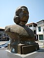 Bust of Maria Aurora


Notable people

- Sonny Angara, senator since 2013.
- Bellaflor Angara-Castillo, governor from 2004 to 2013.
- Manuel L. Quezon, first president of the Commonwealth of the Philippines
- Aurora Quezon, former first lady of the Philippines, wife of President Manuel L. Quezon
See also
References
- ^ "List of Provinces". PSGC Interactive. Makati, Philippines: National Statistical Coordination Board. Archived from the original on 19 April 2016. Retrieved 5 March 2020.
- ^ a b c Census of Population (2020). "Region III (Central Luzon)". Total Population by Province, City, Municipality and Barangay. Philippine Statistics Authority. Retrieved 8 July 2021.
- ^ a b The Brief History of Aurora
- ^ a b c d e "Aurora, Philippines – History". www.aurora.ph. Archived from the original on February 8, 2017. Retrieved February 7, 2017.
- ^ a b Baler During Spanish Occupation in Aurora.ph
- ^ a b "History of Quezon Province". Provincial Government of Quezon. Archived from the original on October 1, 2016. Retrieved April 4, 2016.
- ^ ISBN 971-630-037-9. Retrieved 4 December 2015.
- ^ a b Jose, Diocese of San. "Diocese of San Jose, Nueva Ecija – History". www.dioceseofsanjose.org. Archived from the original on February 8, 2017. Retrieved February 7, 2017.
- ^ "The Archdiocese | Archdiocese of Caceres". caceres-naga.org. Archived from the original on February 8, 2017. Retrieved February 7, 2017.
- ^ National Historical Commission of the Philippines. "History of Baler". National Historical Commission of the Philippines. Retrieved 2012-03-09.
When military district of El Príncipe was created in 1856, Baler became its capital...On June 12, 1902 a civil government was established, moving the district of El Príncipe away from the administrative jurisdiction of Nueva Ecija...and placing it under the jurisdiction of Tayabas Province.
- ^ The picture of territorial evolution of Quezon.

- ^ Republic Act No. 648 (14 June 1951), An Act Creating the Subprovince of Aurora, Which Shall Comprise the Municipalities of Baler, Casiguran, Dipaculao and Maria Aurora, Province of Quezon, retrieved 8 December 2015
- ^ Batas Pambansa Blg. 7 (21 November 1978), An Act Separating the Sub-province of Aurora from the Province of Quezon and Establishing It as an Independent Province, retrieved 8 December 2015
- ^ Malig, Jun (April 24, 2024). "Vice gov assumes top post in Aurora". Philippine Daily Inquirer. Retrieved April 25, 2024.
- ^ Tantingco: The Kapampangan in Us
- ^ a b "Province: Aurora (province)". PSGC Interactive. Quezon City, Philippines: Philippine Statistics Authority. Retrieved 8 January 2016.
- ^ a b "Climate: Aurora". Climate-data.org. Retrieved 8 December 2015.
- ^ Iglesias, Iza; Vargas, Anthony; Cueto, Francis Earl A. (17 October 2015). "3 days of heavy rain". The Manila Times. Retrieved 8 December 2015.
- ^ a b Census of Population (2015). "Region III (Central Luzon)". Total Population by Province, City, Municipality and Barangay. Philippine Statistics Authority. Retrieved 20 June 2016.
- ^ a b c Census of Population and Housing (2010). "Region III (Central Luzon)" (PDF). Total Population by Province, City, Municipality and Barangay. National Statistics Office. Retrieved 29 June 2016.
- ^ a b "Aurora: Housing Unit Occupancy Rate Almost 100 Percent; Table 4. Household Population by Ethnicity and Sex: Aurora, 2000". Philippine Statistics Authority. 11 June 2002. Archived from the original on 5 March 2012. Retrieved 26 July 2016.
- ^ a b Mesina, Ilovita. "Baler And Its People, The Aurorans". Aurora.ph. Retrieved 21 February 2018.
- ^ Baler and Other Sceneries of Aurora
- ^ Lowland Cultural Group of the Tagalogs
- ^ Encyclopedia.com: Ilongot
- ^ Discovering Aurora in phinder.ph
- ^ Aurora: Who We Are in DILG website
- ^ Selaznog, Olag (2013). Ak'kaw Poppo: Talaan ng Salitang Baler (1st ed.). Makati City: Baler Aurora Ngayon Angkan at Kasaysayan (Banak Inc.).
- ^ Batang Baler Ako Website
- ^ OoCities: Batang Baler
- ^ Discover the Philippines: Aurora Province
- ^ "Poverty incidence (PI):". Philippine Statistics Authority. Retrieved December 28, 2020.
- ^ "Estimation of Local Poverty in the Philippines" (PDF). Philippine Statistics Authority. 29 November 2005.
- ^ "2009 Official Poverty Statistics of the Philippines" (PDF). Philippine Statistics Authority. 8 February 2011.
- ^ "Annual Per Capita Poverty Threshold, Poverty Incidence and Magnitude of Poor Population, by Region and Province: 1991, 2006, 2009, 2012 and 2015". Philippine Statistics Authority. 27 August 2016.
- ^ "Annual Per Capita Poverty Threshold, Poverty Incidence and Magnitude of Poor Population, by Region and Province: 1991, 2006, 2009, 2012 and 2015". Philippine Statistics Authority. 27 August 2016.
- ^ "Annual Per Capita Poverty Threshold, Poverty Incidence and Magnitude of Poor Population, by Region and Province: 1991, 2006, 2009, 2012 and 2015". Philippine Statistics Authority. 27 August 2016.
- ^ "Updated Annual Per Capita Poverty Threshold, Poverty Incidence and Magnitude of Poor Population with Measures of Precision, by Region and Province: 2015 and 2018". Philippine Statistics Authority. 4 June 2020.

External links
 Media related to Aurora at Wikimedia Commons
 Geographic data related to Aurora (province) at OpenStreetMap
Places adjacent to Aurora (province) | ||||||||||||||||
|---|---|---|---|---|---|---|---|---|---|---|---|---|---|---|---|---|
| ||||||||||||||||
| Municipalities | |
|---|---|
List of barangays in Aurora | |

| International | |
|---|---|
| National | |