
Cadet Peak
| Cadet Peak | |
|---|---|
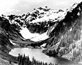
.jpg) Cadet Peak seen from Goat Lake | |
| Highest point | |
| Elevation | 7,186 ft (2,190 m)[1] |
| Prominence | 706 ft (215 m)[1] |
| Parent peak | Kyes Peak[2] |
| Isolation | 1.59 mi (2.56 km)[2] |
| Coordinates | 47°59′07″N 121°20′58″W / 47.985155°N 121.349465°W[1] |
| Geography | |
 Cadet Peak Location in Washington  Cadet Peak Cadet Peak (the United States) | |
| Country | United States |
| State | Washington |
| County | Snohomish |
| Protected area | Henry M. Jackson Wilderness |
| Parent range | Cascade Range |
| Topo map | USGS Blanca Lake |
| Geology | |
| Type of rock | Breccia[3] |
| Climbing | |
| Easiest route | Scrambling[4] |
Cadet Peak is a 7,186 ft (2,190 m) mountain summit near the western edge of the
Mount Baker-Snoqualmie National Forest. The mountain was originally called Foggy Peak, for the Foggy Mine claim on the mountain's north slope, but the name was changed in 1896 to its present name, and the Foggy Peak name was transferred to the peak immediately northwest of Cadet.[3] Back in the old mining days, the long sub-range stretching from Cadet Peak to Sheep Mountain was known as Pride of the Mountains Range.[3] Cadet's nearest higher neighbor is Kyes Peak, 1.59 mi (2.56 km) to the south-southeast.[1] Precipitation runoff from the mountain drains into tributaries of the Sauk River
.
Climate
Cadet Peak is located in the
Cascade Mountains. As fronts approach the North Cascades, they are forced upward by the peaks (orographic lift), causing them to drop their moisture in the form of rain or snow onto the Cascades. As a result, the west side of the North Cascades experiences high precipitation, especially during the winter months in the form of snowfall.[3] Because of maritime influence, snow tends to be wet and heavy, resulting in high avalanche danger.[3] During winter months, weather is usually cloudy, but, due to high pressure systems over the Pacific Ocean that intensify during summer months, there is often little or no cloud cover during the summer.[3] Due to its temperate climate and proximity to the Pacific Ocean, areas west of the Cascade Crest very rarely experience temperatures below 0 °F (−18 °C) or above 80 °F (27 °C).[3]
The months July through September offer the most favorable weather for viewing or climbing this peak.
Geology
The North Cascades features some of the most rugged topography in the
glacial valleys. Geological events occurring many years ago created the diverse topography and drastic elevation changes over the Cascade Range leading to the various climate differences. These climate differences lead to vegetation variety defining the ecoregions
in this area.
The history of the formation of the Cascade Mountains dates back millions of years ago to the late
During the Pleistocene period dating back over two million years ago, glaciation advancing and retreating repeatedly scoured the landscape leaving deposits of rock debris.[5] The U-shaped cross section of the river valleys is a result of recent glaciation. Uplift and faulting in combination with glaciation have been the dominant processes which have created the tall peaks and deep valleys of the North Cascades area.
Gallery
-
 Cadet Peak, west aspect
 -
 Cadet Peak (left) and Gemini Peaks (right) seen from Dickerman Mountain
 -
 Goat Lake, Cadet Peak, ca 1920
 -
 Cadet Peak centered, from northwest


.jpeg)

See also
References
- ^ a b c d "Cadet Peak, Washington". Peakbagger.com.
- ^ a b "Cadet Peak - 7,186' WA". listsofjohn.com. Retrieved 2020-08-14.
- ^ a b c d e f g h Beckey, Fred W. Cascade Alpine Guide, Climbing and High Routes. Seattle, WA: Mountaineers Books, 2008.
- ^ Cadet Peak at Mountaineers.org
- ^ a b c d Kruckeberg, Arthur (1991). The Natural History of Puget Sound Country. University of Washington Press.
External links
- Weather: Cadet Peak
- Aerial photo of east face PBase