
Camelback Mountain
| Camelback Mountain | |
|---|---|
 | |
| Highest point | |
| Elevation | 2,706 ft (825 m) NAVD 88[1] |
| Prominence | 1,334 ft (407 m)[2] |
| Coordinates | 33°30′53″N 111°57′42″W / 33.514723847°N 111.961604211°W[1] |
| Geography | |
 Camelback Mountain | |
| Location | Maricopa County, Arizona, U.S. |
| Parent range | Phoenix Mountains |
| Topo map | USGS Paradise Valley |
| Geology | |
| Mountain type | granite, sandstone |
| Climbing | |
| Easiest route | Echo Canyon trail, Cholla trail |
Camelback Mountain (
History
A cave discovered on the north side of Camelback Mountain indicates that it was used as a sacred site by the prehistoric
In January 1879, United States President
Efforts to protect Camelback Mountain as a natural preserve began in the early 1910s. However, by the 1960s, nearly all of the area had been sold to private interests. Federal and state authorities attempted to stop development above the one thousand and six hundred feet level. They failed to halt development and in 1963 efforts to arrange a land exchange failed in the Arizona State legislature. In 1965, United States Senator Barry Goldwater took up the cause and helped to secure the higher elevations against development. The area became a Phoenix city park in 1968.[7]
The peak lends its name to a major east-west street in the Phoenix area called
Camelback Mountain is designated as a Phoenix Point of Pride.[8]
Geology
The mountain is composed of a geologic unconformity between two separate rock formations. The higher part of the peak is Precambrian granite (ca. 1.5 billion years old). The head of the camel is predominantly red sedimentary sandstone from the Chattian stage of the Oligocene epoch (ca. 25 million years old).[9]
Recreation
Two hiking trails ascend 1,280 feet (390 m) to the peak of Camelback Mountain. The Echo Canyon Trail is 1.14 miles (1900 m) and the Cholla Trail is 1.4 mi (2300 m). Both trails are considered strenuous with steep grades. The hiking path has dirt, gravel, boulders, and some handrail-assisted sections. The average hike requires a round trip time of 1.5 to 3 hours.[10]
The Praying Monk is a red sandstone rock formation which is used for rock climbing. Located on the northern slope, the formation resembles the silhouette of a person kneeling in prayer.[11] It rises approximately 100 feet (30 m) and the eastern face has several permanent anchor bolts for attaching a belay rope.[12]
Gallery
-
 Aerial view
 -
 Camelback summit, viewed from red sandstone formation to the northwest
 -
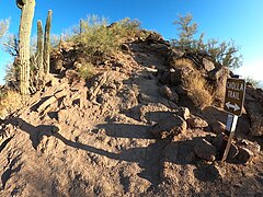 Cholla Trail.
 -
 Summit, viewed from Cholla Trail to the southeast.
 -
 Cave on north side of mountain.
 -
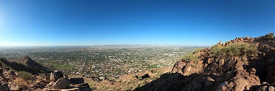 Panorama, just below the summit, at right.
 -
 Echo Canyon Trail.
 -
 Red sandstone formation just off Echo Canyon Trail.
 -
 View from south end of summit showing formations as well as distant Piestewa Peak (background, center).


.JPG)
.JPG)


.jpg)

See also
- List of historic properties in Phoenix, Arizona
References
- ^ a b "Camels Back 2". NGS Data Sheet. National Geodetic Survey, National Oceanic and Atmospheric Administration, United States Department of Commerce. Retrieved 2008-11-25.
- ^ "Camelback Mountain, Arizona". Peakbagger.com. Retrieved 2008-11-25.
- ISBN 978-0-7385-4840-1.
- ^ (Driggs 2008, p. 23)
- ^ (Driggs 2008, p. 27)
- ^ (Driggs 2008, p. 27)
- ^ Lindstrom, Matthew J.; Bartling, Hugh (2003). "8: "The Straw that Broke the Camel's Back"". Suburban sprawl: culture, theory, and politics. Rowman & Littlefield.
- ^ "Phoenix Points of Pride". City Attractions. City of Phoenix. 2014. Archived from the original on 2014-02-19. Retrieved 2014-02-01.
- ^ (Driggs 2008, p. 9)
- ISBN 9780897325936.
- ^ (Driggs 2008, p. 20)
- ISBN 0-910152-17-9.
External links
- Camelback Mountain. City of Phoenix official website.
- Camelback Mountain hiking information. ClimbCamelback.com.
- Echo Canyon trail description, GPS track, photos, trip logs and more. HikeArizona.com.
- Cholla trail description, GPS track, photos, trip logs and more. HikeArizona.com.
- Trailhead information, directions, photos, tips, history, wildlife and more. HikeCamelback.com.
| International | |
|---|---|
| National | |