
Canche
| Canche | |
|---|---|
 The Canche at Montreuil-sur-Mer | |
 Watershed of the Canche River watershed | |
  | |
| Location | |
| Country | France |
| Physical characteristics | |
| Source | |
| • location | Pas-de-Calais |
| Mouth | |
• location | English Channel |
• coordinates | 50°32′27″N 1°35′56″E / 50.54083°N 1.59889°E |
| Length | 100 km (62 mi) |
| Basin size | 1,274 km2 (492 sq mi) |
| Discharge | |
| • average | 15.1 m3/s (530 cu ft/s) |
The
The river rises at
History
The valley of the Canche has been occupied by man since ancient times because of the productive nature of the land. The unhealthy aspect of marshland means much has been done over the centuries to drain the land efficiently, which has brought about the partial destruction of its original character. The principal activities of the village communities occupying the valley and its surrounds have been (and still are) farming, fishing and reed harvesting.[2]
The extraction of peat from the marshes of the lower river was known in the 16th century; peat being the principal means of heating and also a multi-purpose fertilizer.[2] The alder tree, which grew well in the local marshy soils, contributed to bind the ground, and produced timber. It was realized that forestry also helped in drainage. Further developments in the 18th century saw permanent enclosures with animals being fenced-in and property boundaries being created by the planting of hedges and the digging of ditches, contributing to organized and cooperative farming methods.
The 18th century also saw the emergence of new perceptions of marshland, long considered as unhealthy places in which to live.[citation needed] Administrative authorities encouraged action to recover the peat marshes by drainage work and the planting of more trees. The reduction of marshland again allowed for even more areas of cultivation to feed the increasing population.
During the 19th century, technical progress (for example, the replacement of
Environmental issues

The Canche estuary was the first site in northern France where a conservation victory, in respect of the coast, was first achieved, in 1976.[vague] Plans had been made to put in place an earlier project, dating from the 1960s, to create an artificial environment on the estuary. The work included creating a harbour and a marina. This was supposed to be “compensation” for extracting the waters of the Canche at Hesdin in order to supply the city of Lille. Of course, this threatened to destroy the rich wildlife and flora of the estuary. The mobilisation of the local inhabitants, various associations and many scientists, after many public enquiries and heated arguments, stopped the plans and left the estuary to nature.[4]
Flora and fauna
With
Gallery
-
 The millrace of the Moulin Blonde at Frévent, south of St. Pol
 -
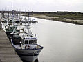 Étaples - The Canche estuary
 -
 Common shelduck on the estuary
 -
 Map of Canche Bassin


See also
References
- .
- ^ a b Helga Scarwell et Magalie Franchomme, Autour des zones humides : espaces productifs d'hier et conflits d'aujourd'hui, La revue en sciences de l'environnement: Vertigo, 1 mai 2005. Read online
- ^ a b The estuary of the Canche Archived 2007-10-18 at the Wayback Machine
- ^ The barrage project on the Fédération Nord-Nature website.
- Carte Géologique de la France à l'échelle du millionième 6th edn. BRGM (2003) ISBN 2-7159-2158-6
External links
- Site de l'Agence de l'eau Bassin Artois-Picardie (in French)
- Site personnel SAGE de la Canche (in French)
- Tourisme dans la vallée de la Canche Archived 2021-04-18 at the Wayback Machine (in French)
| International | |
|---|---|
| National | |
| Other | |