
Castel Ruggero
Castel Ruggero | |
|---|---|
St Mary of the Snows | |
| Saint day | 5 August |
| Website | Official website |
Castel Ruggero, also spelled as Castelruggero, is a southern Italian village and hamlet (frazione) of Torre Orsaia, a municipality in the province of Salerno, Campania. As of 2011, it had a population of 400.[1]
History
The village was founded in 1150, as a military camp, that hosted the troops of Roger II of Sicily, and was named Castra Rogerii. Later, it was named Torre Superiore (i.e. "Upper Tower"), to distinguish it from Torre Inferiore ("Lower Tower", the current Torre Orsaia). In 1811 the village resumed the original name and became, until 1927, an autonomous municipality, when it merged in Torre Orsaia.[3]
Geography
Castel Ruggero is a hill village located in southern
Main sights
Main sights of the village include the old town and its palaces (De Siervi, Imbriaco, Mariosa, Pecorelli) and the Sanctuary of St. Anthony.[5]
Transport
Castel Ruggero is crossed in the middle by the national highway SS 18, and the exit "Torre Orsaia", part of the SS 517/var highway Padula-Policastro, that is 8 km south. Torre Orsaia station, located in the village of Calleo and part of the Naples-Salerno-Reggio Calabria railway, is 7 km south.
Gallery
-
 Mariosa Palace
 -
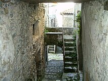 A road in the old town
.jpg)
-2.jpg)
See also
References
- ^ a b (in Italian) Info on italia.indettaglio.it
- ^ (in Italian) Castel Ruggero on tuttocitta.it
- ^ (in Italian) History of Castel Ruggero
- ^ 1237466499 Castel Ruggero on OpenStreetMap
- ^ (in Italian) Info on Torre Orsaia municipal website: section "
Vivere la città", then "Musei e monumenti", then see the list
External links
- (in Italian) Castel Ruggero website
- (in Italian) Castel Ruggero and Torre Orsaia