
Castercliff
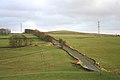
 Viewed from Back Lane | |
 Shown within the Borough of Pendle | |
| Location | Pendle, Lancashire, England |
|---|---|
| Coordinates | 53°50′30″N 2°10′56″W / 53.8417°N 2.1823°W |
| Type | Hillfort |
| Length | 115 m (377 ft) |
| Width | 76 m (249 ft) |
| Area | 0.80 ha (2.0 acres) |
| Height | 1.5 m (4 ft 11 in) |
| History | |
| Founded | 510±70 BC |
| Site notes | |
| Excavation dates | 1971 |
| Official name | Castercliff Small Multivallate Hillfort |
| Reference no. | 45247 |
Castercliff is an
It is located on a hilltop overlooking the valley system of the
The summit of the hill is 280 metres (920 ft) above sea level and the surrounding ground falls rapidly on all sides except the south east. Here a neck of land, dropping 18 metres (60 ft) from the summit, connects it to similarly high ground about 370 metres (1,200 ft) away. Streams spring from either side of the ridge and the deep valleys which they have cut, especially on the south, offer additional defence.[2]
Excavations during the 1970s appear to show that the site was not completed, and no evidence of occupation was unearthed.

The hillfort has been damaged by coal mining with old bell pits evident both inside and around the site.[1]
Media gallery
-
 Published in The Victoria History of the County of Lancaster Vol 2 (1906)
 -
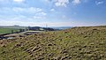
 One of the many bell pit circles on top of the fort
 -
 The view from the summit toward Walton's Spire to the southeast
 -
 On the eastern slope looking southwest, showing a section of the ramparts


See also
References
- ^ a b Historic England. "Castercliff small multivallate hillfort (1007404)". National Heritage List for England. Retrieved 1 January 2021.
- OCLC 59375181, retrieved 1 January 2021
- ^ Excavation of the hillfort of Castercliff, Nelson, Lancashire, 1970-71 Trans. Lancs. & Ches. Antiq. Soc. 81, 111-30
- ^ Speight, Harry (1898). Chronicles and stories of old Bingley. A full account of the history, antiquities, natural productions, scenery, customs and folklore of the ancient town and parish of Bingley, in the West Riding of Yorkshire. University of California Libraries. London : Elliot Stock.
- ^ Lancashire County Council Archived 2011-06-13 at the Wayback Machine
External links
This article relating to archaeology in the United Kingdom is a stub. You can help Wikipedia by expanding it. |