
Barbury Castle
 Aerial view of Barbury Castle | |
 Shown within Wiltshire | |
| Location | Wiltshire |
|---|---|
| Coordinates | 51°29′07″N 1°47′11″W / 51.4853°N 1.7865°W |
| Type | Hillfort |
| Area | 12 acres (4.9 ha) |
| History | |
| Periods | Iron Age |
| Site notes | |
| Public access | yes, The Ridgeway |
| Official name | Barbury Castle: a hillfort and bowl barrow |
| Designated | 18 August 1882 |
| Reference no. | 1014557 |
Barbury Castle is a scheduled hillfort in Wiltshire, England.[1] It is one of several such forts found along the ancient Ridgeway route. The site, which lies within the Wessex Downs Area of Outstanding Natural Beauty, has been managed as a country park by Swindon Borough Council since 1971. It is on Barbury Hill, a local vantage point, which, under ideal weather conditions, commands a view across to the Cotswolds and the River Severn. It has two deep defensive ditches and ramparts.[2]
History
The site was first occupied some 2,500 years ago, and was then in use during the Roman occupation of the area. Archaeological investigations at Barbury have shown evidence of a number of buildings, indicating a village or military garrison at this time.
In the 6th century the site became part of the
In World War II the War Ministry appropriated the site for US Army Air Force anti-aircraft guns; the bases for these are apparently visible as hollows around the edge of the fort interior.[4]
In 1996, a geophysical survey revealed traces of 40
In 2009, English Heritage (now Historic England) carried out a National Mapping Programme project which comprised an interpretation, transcription and analysis of all archaeological features visible on aerial photographs in the environs of Barbury Castle.[6]
Location
Barbury Castle is at
Gallery
-
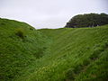 Steep earthworks looking northwards
 -
 Aerial view from above
 -
 Barbury Castle showing the scale of the present-day structure
 -
 Looking westwards towards the River Severn
 -
 The Iron Age house under construction, July 2006
 -
 Plans of the Iron Age house


See also
References
- ^ a b Historic England. "Barbury Castle: a hillfort and bowl barrow (1014557)". National Heritage List for England. Retrieved 10 January 2018.
- ^ a b c "Leisure and sport: Barbury Castle". Swindon Borough Council. Archived from the original on 16 January 2006.
- Oxoniensia. LIX. Oxford Architectural and Historical Society: 56. Retrieved 6 October 2011.
- ^ a b The Modern Antiquarian: Barbury Castle
- ^ "Iron Age replica goes up in flames". Swindon Advertiser. 29 October 2008. Retrieved 13 June 2022.
- ^ "Barbury Castle Environs: Air Photo Survey and Analysis". Historic England. 9 October 2009. Retrieved 5 July 2022.
External links
![]() Media related to Barbury Castle at Wikimedia Commons
Media related to Barbury Castle at Wikimedia Commons
- Swindon Borough Council web page on Barbury Castle, archived in 2013