
Cherry Burton
| Cherry Burton | |
|---|---|
2011 census)[1] | |
| OS grid reference | SE989420 |
| • London | 165 mi (266 km) S |
| Civil parish |
|
| Unitary authority | |
| Ceremonial county | |
| Region | |
| Country | England |
| Sovereign state | United Kingdom |
| Post town | BEVERLEY |
| Postcode district | HU17 |
| Dialling code | 01964 |
| Police | Humberside |
| Fire | Humberside |
| Ambulance | Yorkshire |
| UK Parliament | |
Cherry Burton is a village and
History
The village is mentioned in the Domesday Book as Burtone, and belonging to the then Archbishop of York.[5] The name derives from a combination of Old and Middle English; Burh-tūn and Chiri, which means a fort enclosure; a farm with a palisade and a cherry tree.[6] Due to its location, some 1.2 miles (2 km) north of Bishop Burton, the village was sometimes known as North Burton (or even rarer, as Sheriff Burton).[7][8]
Historically in the
The civil parish is formed by the village of Cherry Burton and the
The village has a
Sports in the village include cricket, football, tennis, and rounders. Clubs for cricket and football have junior sections. Just outside of the village is a golf course and leisure park currently under development. A
The village is one of the few in the UK awarded
Cherry Burton was served by
Gallery
-
 Aerial Photo Cherry Burton c. 1960
 -
 Cherry Burton Cricket Club team photo, 15 May 2008
 -
 A winter day in Cherry Burton
 -
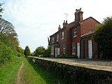 Cherry Burton railway station
 -
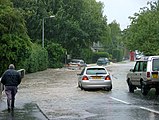 Cherry Burton in the 2007 floods


References
- ^ Office for National Statistics. Retrieved 16 February 2018.
- ^ "Genuki: Cherry Burton, Yorkshire (East Riding)". www.genuki.org.uk. Retrieved 13 January 2020.
- OCLC 427481667.
- ISBN 9780319244906.
- ^ "[Cherry] Burton | Domesday Book". opendomesday.org. Retrieved 13 January 2020.
- ISBN 0-19-869103-3.
- OCLC 3552084.
- ISBN 1-85058-749-3.
- ^ "Genuki: CHERRY BURTON: Geographical and Historical information from the year 1892., Yorkshire (East Riding)". www.genuki.org.uk. Retrieved 13 January 2020.
- ^ "History of Cherry Burton, in East Riding of Yorkshire and East Riding | Map and description". www.visionofbritain.org.uk. Retrieved 13 January 2020.
- ISBN 0-300-09593-7.
- ^ UK Census (2001). "Local Area Report – Cherry Burton Parish (1543504209)". Nomis. Office for National Statistics. Retrieved 7 December 2018.
- ^ a b c McCandlish, Sophie (12 January 2020). "A village rooted in agriculture and Fairtrade". The Yorkshire Post. Retrieved 13 January 2020.
- ^ "Cherry Burton Church of England Voluntary Controlled Primary School URN: 118002". reports.ofsted.gov.uk. 16 October 2019. Retrieved 13 January 2020.
- ^ Historic England. "Church of St Michael (Grade II) (1310173)". National Heritage List for England. Retrieved 13 January 2020.
- ISBN 0-300-09593-7.
- ^ "Fairtrade - Towns List". Fairtrade Foundation. Archived from the original on 1 February 2010. Retrieved 25 July 2008.
- ^ "Welcome to the Cherry Burton Fairtrade and Local Produce Project". Cherry Burton Fairtrade and Local Produce Project. Retrieved 19 August 2009.
- ^ "Work starts on scheme to prevent flooding". The Yorkshire Post. 6 December 2011. Retrieved 13 January 2020.
- OL 11956311M.
- ^ "Disused Stations: Cherry Burton Station". disused-stations.org.uk. Retrieved 13 January 2020.
- ^ "TROD Path to Etton Bridge". Cherry Burton Parish Council. Retrieved 13 January 2020.
- Gazetteer — A–Z of Towns Villages and Hamlets. East Riding of Yorkshire Council. 2006. p. 4.
External links
- Cherry Burton in the Domesday Book
| Unitary authorities | |
|---|---|
| Major settlements (cities in italics) |
|
| Rivers | |
| Canals | |
| Topics |
|
| International | |
|---|---|
| National | |