
Clatsop Plains
Clatsop Plains | |
|---|---|
Wetlands | |
 Aerial view of the northern Clatsop Plains | |
 Clatsop Plains | |
| Coordinates: 46°04′04″N 123°55′51″W / 46.067884°N 123.930696°W | |
| Location | Clatsop County, Oregon |
| Age | Quaternary |
The Clatsop Plains are an area of
The Clatsop Plains
|

The plains are named for the Clatsop tribe of Native Americans who lived in the area at the time of the arrival of Europeans and European Americans by ship at the end of the 18th century and by land at the beginning of the 19th century.
These plains were developed from sand filling in the shoreline during the late Quaternary age. The northern portion is a result of the creation of the south jetty on the Columbia River built in 1885. Within the plain are several lakes including Cullaby, Sunset (Neacoxie), Smith, and Coffenbury. The latter three are filled by groundwater and not local streams or rivers.[3]
The first white settlement of Clatsop Plains was by two
The first
A community called "Clatsop Plains" was established and incorporated in 1870, primarily for the purpose of restricting cattle grazing along the sea ridge. This grazing was destroying the ridge grass and plants that prevented sand from blowing onto the nearby farms. As incorporated originally, "Clatsop Plains" extended from the Skipanon River to Seaside. An actual town eventually came into being about a mile north of Seaside, and was later absorbed into Gearhart. However, its early proximity to Seaside is probably why Seaside itself was sometimes referred to Clatsop Plains.[5]
The coastal grassy areas of Clatsop Plains was home to the
A stretch of ![]() US 101, the Oregon Coast Highway, runs through most of the length of Clatsop Plains.
US 101, the Oregon Coast Highway, runs through most of the length of Clatsop Plains.
Gallery
-
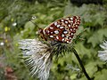 Oregon silverspot butterfly
 -
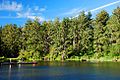 Coffenbury Lake (named for an early settler, George W. Coffenberry/Coffinberry)

_(clatDA0097a).jpg)
References
- ^ "Searching for the Lost Village: An 1805 Lewis and Clark Site along the Oregon Coast". University of Wisconsin - Eau Claire. 2005. Retrieved April 28, 2014.
- ^ "A GROUND PENETRATING RADAR INVESTIGATION OF AN 1805 LEWIS AND CLARK SITE, OREGON" (PDF). University of Wisconsin - Eau Claire. 2005. Retrieved April 28, 2014.
- ^ Orr, Elizabeth and William Orr, and Ewart Baldwin. Geology of Oregon. Kendall/Hunt Publishing, 1992, 4th edition.
- ^ "Chronology of Clatsop County History - The First 400 Years From the 1500s to 1900". Clatsop County Historical Society.
- ^ "Clatsop County Reference Information - The History of Seaside, Oregon". clatsop.com.
- U.S. Fish and Wildlife Service. Retrieved April 28, 2014.
External links
Early history of Oregon (1500–1806) | ||
|---|---|---|
| Topics |  | |
| Events | ||
| Places | ||
| People | ||
| Oregon history | ||