
Willamette Falls
| Willamette Falls | |
|---|---|
 | |
 | |
| Location | Oregon City / West Linn, Clackamas County, Oregon, U.S. |
| Coordinates | 45°21′09″N 122°37′03″W / 45.35239°N 122.61763°W |
| Type | Block |
| Total height | 40 ft (12 m) |
| Number of drops | 1 |
| Average flow rate | 30,849 cu ft/s (874 m3/s) |
The Willamette Falls is a natural waterfall on the Willamette River between Oregon City and West Linn, Oregon, in the United States. It is the largest waterfall in the Northwestern United States by volume, and the seventeenth widest in the world.[1] Horseshoe in shape, it is 1,500 feet (460 m) wide and 40 feet (12 m) high with a flow of 30,849 cu ft/s (874 m³/s), located 26 miles (42 km) upriver from the Willamette's mouth. Willamette Falls is a culturally significant site for many tribal communities in the region.
Opened in 1873 and closed since 2011, the Willamette Falls Locks allowed boat traffic on the Willamette to pass into the main Willamette Valley.
Human history

.JPG)
Willamette Falls is an important location for many tribes.
European
Navigating past the falls was not possible until the completion of the

Industrial history
The Willamette Falls Electric Company (later renamed Portland General Electric) was formed in 1888 to build a hydro-electric generation facility at the falls. Four turbine-driven dynamos were built on the east end of the falls. A 14-mile (23-kilometer) long transmission line to Portland was built, becoming the first long-distance transmission of electrical energy in the United States in 1889.[8][9]
In 1895 Portland General Electric built a second generation station on the west side of the falls. The newer plant, called the
The falls have been home to several paper mills beginning with the Oregon City Paper Manufacturing Co. in 1866. The Willamette Pulp and Paper Co. opened on the West Linn side during 1889. The ownership of the mills has changed several times. The last two remaining mills in 2011 were owned by the West Linn Paper Company and the Blue Heron Paper Company. West Linn Paper Company announced it was shutting down in October 2017,[11] and reopened in November 2019 as Willamette Falls Paper Company.[12] Blue Heron Paper Company closed its mill in February 2011.
The Blue Heron site has subsequently been auctioned off for redevelopment. The milling facilities were sold to a Canadian investment firm, NRI Global, Inc., which has begun work removing the old machinery and cleaning the grounds of contamination.
Ecology and revitalization
The industrialization of the area led to diminishing salmon and steelhead runs, prompting the construction of a fish ladder in 1882. A new fish ladder, built in 1971, is operated by the Oregon Department of Fish and Wildlife. The estimated spring chinook salmon run for 2007 was 52,000.[18] The industrialization has precluded public access to the base of the waterfall for well over a century, but as of 2017 a process to redevelop the Blue Heron Paper Mill site and provide public access to the area, including a river walk, is underway.[19]
Description and access
This section needs additional citations for verification. (September 2022) |
The falls is a horseshoe shaped block waterfall caused by a basalt shelf in the river floor. The 40 ft (12 m) high and 1500 ft (457 m) wide falls occur 26 river miles (42 km) upstream from the Willamette's confluence with the Columbia River. Operated by the U.S. Army Corps of Engineers, the lock was a four lock canal and was the oldest continuous operating, multiple lift navigation canal in the United States.
The public can view the falls from viewpoints on the bluffs of
Gallery

-
 The falls in 1918
 -
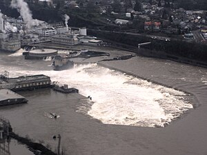
 The falls after the Hanukkah Eve windstorm of 2006 swelled the Willamette River and part of the paper mill
 -
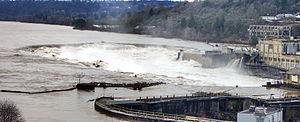
 An aerial view of the Willamette Falls with the river near flood stage, taken on January 22, 2006
 -
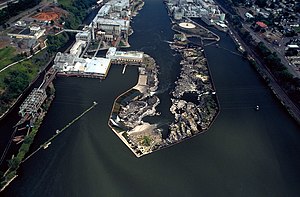 View is downriver facing northeast. The locks are at far left.
 -
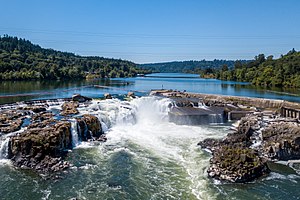 Willamette Falls as seen from overhead via a drone on July 19, 2017


See also
References
- ^ "World's Largest Waterfalls". World Waterfall Database. Archived from the original on September 27, 2007.
- ^ "A Legend: Tallapus and the Hyas Tyee Tumwater (Willamette Falls)". Based on "The Reminiscences of Louis Labonte" in the Oregon Historical Quarterly, 1901. Oregon Historical Quarterly. Retrieved January 24, 2018.
- ^ 10 Stat. 1143, also known as the "Treaty with the Kalapuya Etc."
- ^ Established by President James Buchanan's Executive Order dated June 30, 1857; printed in Indian Affairs: Laws and Treaties Vol. 1 (Charles Joseph Kappler, ed.), p.886
- ^ Arden, Amanda (September 8, 2022). "Tribe decides new name of Willamette Falls site". KOIN.com. Retrieved September 9, 2022.
- ^ Eastman, Janet (September 8, 2022). "Grand Ronde tribe names its 23-acre Willamette Falls site Tumwata Village". OregonLive. The Oregonian. Retrieved September 8, 2022.
- ^ "The City on Willamette Falls". End of the Oregon Trail Interpretive Center.
- ^ "Power Generation" (PDF). Northwest RiverPartners. Archived from the original (PDF) on January 6, 2014.
- ^ "PGE - 2/5/04 News Release". Portland General Electric. Archived from the original on September 28, 2007.
- ^ "Willamette Falls & Sullivan Plant History". Portland General Electric. Retrieved July 17, 2018.
- ^ "End of an era: West Linn paper mill to close, after 128 years". Northwest Labor Press. October 31, 2017. Retrieved July 17, 2018.
- ^ "West Linn paper mill reopens, 120 employees hired". kgw.com. Retrieved July 20, 2020.
- ^ Case, Elizabeth (August 4, 2013). "Mill runoff gets a cleanup: With a compost wall and rainwater gardens, metals from Blue Heron mill won't contaminate Willamette". The Sunday Oregonian. p. B1. Retrieved August 8, 2013.
- ^ Mayes, Steve (June 25, 2013). "California developer to purchase historic site of Blue Heron Paper mill in Oregon City". The Oregonian. Retrieved August 8, 2013.
- ^ Mayes, Steve (February 3, 2014). "Langley Investment Properties drops bid to buy Blue Heron paper mill site". The Oregonian. Retrieved February 9, 2014.
- ^ Mayes, Steve (May 20, 2014). "George Heidgerken buys Blue Heron paper mill almost sight unseen but he envisions great things". The Oregonian. Retrieved January 12, 2015.
- ^ "Confederated Tribes of Grand Ronde purchase paper mill site". KOIN. August 16, 2019. Retrieved October 29, 2019.
- ^ "2007 Willamette Spring Chinook Catch and Falls Counts". Oregon Department of Fish and Wildlife. Archived from the original on February 4, 2007.
- ^ Jones, Joelle (June 30, 2023). "'A sacred, special place': Joint project to restore public access to the Willamette Falls is underway". KOIN. Retrieved July 2, 2023.
- ^ Mesh, Aaron (September 14, 2022). "Cheryle A. Kennedy, Chairwoman of the Grand Ronde Tribes, Describes a Vision for Willamette Falls". Willamette Week. Retrieved September 15, 2022.
External links
- Willamette Falls Heritage Foundation - Partners, stewards and advocates of the culture and heritage at Willamette Falls
- Waterfalls Northwest: Willamette Falls
- Willamette Falls Legacy Project, redevelopment of the Blue Heron Paper Mill site
- The Hidden World Of Oregon's Overlooked Falls Documentary produced by Oregon Public Broadcasting
Early history of Oregon (1500–1806) | ||
|---|---|---|
| Topics |  | |
| Events | ||
| Places | ||
| People | ||
| Oregon history | ||