
Cranford Park


Cranford Countryside Park is a 144-acre
The park features in the London Parks & Gardens Trust's ‘Inventory of Historic Green Spaces’ and is centrally positioned on the Crane Valley's parkland chain.
History
The park has significant historical importance, with settlements in the area including within the area of the park dating at least from
The park surrounds and extends from the church of St Dunstan with Holy Angels, Parish of Cranford. The church is thought to have been founded during the reign of Edward the Confessor, and the surrounding land has been part of the estates of the Knights Templar, Sir Roger Aston and Elizabeth Carey, Lady Berkeley whose living descendants still have possessions here today.[3] It is likely that a place of worship of some capacity has stood on this site since at least the 8th century The earliest known reference is to be found in Sir Montague Sharpe's edition of Middlesex in British, Roman and Saxon Times, in which he mentions the church at Cranford as one of those built upon the site of a compita, or 'little chapel', which usually stood at the cross-roads, and where the Romans offered sacrifices to their rural gods twice a year.[3]
As of 2024, work is currently underway to create a café on the site where the house formerly stood, with access to the underground cellars which remain from the original building.[4]
Gallery
-
 Open space with trees
 -
 Bridge over a ha-ha in woodland
 -
 River Crane in Cranford Park
 -
 The Stable Block
 -
 Interior of the Stable Block


Church of St Dunstan
-
 Church tower of St Dunstan
 -

-
 Tony Hancock Memorial
 -
 Interior of the church
 -
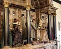 Aston Monument
 -
 Tomb of Elizabeth Carey, Lady Berkeley


_-_geograph.org.uk_-_1002884.jpg)


References
- ^ a b c "About Us". cranfordparkfriends.org.
- ^ a b c "London Gardens Online". londongardensonline.org.uk. Archived from the original on 2016-03-04.
- ^ a b "Saint Dunstan - the Parish Church". saintdunstan.org.uk.
- ^ "Cranford County Park catering update". Hillingdon Council. Retrieved 2024-03-13.


