
Croxall Lakes
| Croxall Lakes | |
|---|---|
National Forest, Staffordshire, United Kingdom | |
| Coordinates | 52°43′39″N 1°43′14″W / 52.727461°N 1.720452°W |
| Type | Quarry lake |
| Surface area | West: 11 ha (27 acres) East: 2.7 ha (6.7 acres) |
Croxall Lakes is a
Location
Croxall Lakes is located between the villages of
The site owes its existence to its geology, which comprises
Features

The reserve is 24.2 hectares (60 acres) in extent, centred on former sand and gravel workings. The reserve comprises two lakes split by an elevated main railway line carrying the Cross Country Route. The west side is dominated by an 11 hectares (27 acres) lake. The east side has lowland wet grassland, rushy pastures and mature trees surrounding the 2.7 hectares (6.7 acres) lake. Access is available from the car park at the southern end of the reserve, and there are hard pathways. On the lake shores are a variety of bird hides and screens.
On the north eastern shore of the western lake is a Noon Column. Erected in 2006 as part of the National Forest Company's LANDshapes project, the Noon Column was created by David Nash and is sculpted from English oak. The sun will shine through the vertical slot for 10–15 minutes at 'true' noon on midsummer and midwinter's days, creating a line of light in the shadow cast by the column.
Wildlife
The location of the lakes, at the meeting point of three rivers makes it an ideal stop off point for migrating birds. Different birds use the reserve at different times of the year. In winter ducks such as
The Staffordshire Wildlife Trust have undertaken a number of projects to restore the site as a wildlife haven. These works include excavation of scrapes for wading birds and the creation of shallows and reedbeds on the two main lakes providing cover and nesting areas for breeding birds. Parts of the banks have been re-profiled and the resulting soil deposited into the lake to make more shallows and larger reedbeds. The process is known as 'river braiding' and creates a diversity of river features with still pools, shallow riffles and gravel islands which helps to restore natural river processes and better wildlife habitat.
The
Ownership and management
The reserve lies within the
Gallery
-
 The larger lake viewed across the lower Tame from the National Memorial Arboretum, showing a connecting channel, allowing flood water to flow between river and lake.
 -
 Croxall lakes viewed from highest point of Arboretum, across the Tame.
 -
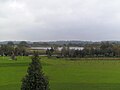
 View westward across the main, western lake at Croxall, which is about 11 hectares in area. The Tame lies below the embankment on the far side of the lake.


