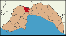
Döşemealtı
Döşemealtı | |
|---|---|
District and municipality | |
 Map showing Döşemealtı District in Antalya Province | |
| Coordinates: 37°01′25″N 30°36′04″E / 37.02361°N 30.60111°E | |
| Country | Turkey |
| Province | Antalya |
| Government | |
| • Mayor | Turgay Genç (CHP) |
| Area | 687 km2 (265 sq mi) |
| Population (2022)[1] | 79,495 |
| • Density | 120/km2 (300/sq mi) |
| Time zone | UTC+3 (TRT) |
| Area code | 0242 |
| Website | www |

Döşemealtı is a municipality and
Turkmens) were also settled in Döşemealtı.[4]
It was declared as seat of township in 1972 and a district center within Greater Antalya in 1998.
Composition
There are 32
neighbourhoods in Döşemealtı District:[5]
References and notes
- ^ TÜİK. Retrieved 22 May 2023.
- ^ Büyükşehir İlçe Belediyesi, Turkey Civil Administration Departments Inventory. Retrieved 8 June 2023.
- ^ "İl ve İlçe Yüz ölçümleri". General Directorate of Mapping. Retrieved 22 May 2023.
- ^ Mayor's page (in Turkish)
- ^ Mahalle, Turkey Civil Administration Departments Inventory. Retrieved 22 May 2023.

