Damascus, Pennsylvania
Appearance
Damascus, Pennsylvania | |
|---|---|
| Village of Damascus | |
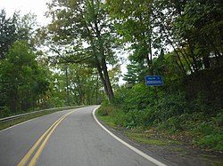
 "Welcome to Pennsylvania" sign on Pennsylvania Route 371 in Damascus. | |
| Nickname: Shields Mills[1] (historical) | |
| Coordinates: 41°42′11.3184″N 75°4′5.6064″W / 41.703144000°N 75.068224000°W | |
| Country | United States |
| State | Pennsylvania |
| County | Wayne
|
FIPS code | 42-127-18104 [6] |
| Major Roads | |
| Waterways | Beaverdam Creek,[7] Delaware River |
Damascus is a
New York State, in the run-up to the Independence Day
holiday, in which observance fireworks are used extensively.
History
The Damascus Post Office has been in operation since January 24, 1824.[8]
References
- ^ Mathews, Alfred (1886). History of Wayne, Pike, and Monroe Counties, Pennsylvania. Philadelphia: R. T. Peck & Company. p. 458. Retrieved December 4, 2014.
- ^ "District Magistrate". Wayne County, PA. Wayne County Courthouse. 2014. Archived from the original on November 27, 2014. Retrieved November 14, 2014.
- ^ Herschell, Don (September 22, 1995). "Why name your town Ninevah?". Observer-Reporter. Washington and Greene Counties, Pennsylvania. p. B5. Retrieved May 24, 2015.
- ^ a b "Damascus". Geographic Names Information System. United States Geological Survey, United States Department of the Interior. August 2, 1979. Retrieved May 24, 2015.
- ^ "Look up a ZIP Code". USPS.COM. USPS. 2015. Retrieved May 24, 2015.
- ^ "Census Demographic Profiles, Damascus Township" (PDF). U.S. Census Bureau. Census 2000. Archived (PDF) from the original on January 13, 2016. Retrieved May 24, 2015.
- ^ "Beaverdam Creek". Geographic Names Information System. United States Geological Survey. August 2, 1979. Retrieved May 24, 2015.
- ^ "Postmaster Finder Post Offices by County". United States Postal Service. USPS. 2015. Retrieved May 24, 2015.


