
Danube Gorge (Weltenburg)
| Danube Gorge/ Weltenburg Narrows (Weltenburger Enge) | |
|---|---|
IUCN category IV (habitat/species management area) | |
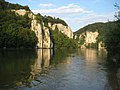
 The Weltenburg Narrows near Weltenburg Abbey | |
| Location | Kelheim, Lower Bavaria, Bavaria, Germany |
| Coordinates | 48°54′01″N 11°49′49″E / 48.900278°N 11.830278°E |
| Area | 5.6 |
| Designation | NSG200.002 (NSG-00089.01) |
| Established | 11 May 1970 |

The Danube Gorge near
Location
The Weltenburg Narrows lies on the Lower Bavarian section of the
Description
The area is a designated nature reserve and bears the cadastre number NSG200.002.[1] The area was designated as a natural monument under King Ludwig I of Bavaria as early as 1840. The nature reserve, which has existed since 1938, was awarded the European Diploma on 5 March 1978. It is part of the Natura 2000 network and the protected area of DE7136301, Weltenburg Narrows and Hirschberg and Altmühlleiten.[2]
In addition, the area is also geotope no. 273R005.[3] In 2002 the Weltenburg Narrows was awarded an official seal by the Bavarian Minister for the Environment for being one of Bavaria's most beautiful geotopes.[4] In 2006 The Danube Gorge was listed among the 77 outstanding national geotopes of Germany.[5]

Geologically the Weltenburg Narrows belong to the
-rich formations in Germany, which was laid down about 150 million years ago when the area was still a shallow sea.The
By contrast with the enormous water depth at the site of the actual gorge, there is a less striking stretch of river about halfway between Kelheim and Weltenburg, the so-called Wipfelsfurt. This is the shallowest point in the Danube between Ingolstadt and Regensburg. The bowl was probably formed by a meteorite during the Ries Event 15 million years ago.
Gallery
-
 View of the Danube Gorge from Weltenburg Abbey
 -
 Striking rock formation (the Bavarian Lion) in the actual gorge
 -
 Overview of the gorge areas from the Michelsberg
 -
 View through the Danube Gorge of Liberation Hall (Befreiungshalle)
 -
 In the Long Wall (Lange Wand), the most dangerous gorge rock, there are rings once used to assist boats travelling upstream.
 -
 The patron saint, St. Nepomuk, on the Long Wall


See also
- Iron Gates – a gorge on the Danube near Orșova, Romania
References
- ^ Bayrisches Staatsministerium Umwelt und Gesundheit, NSG200.002 Naturschutzgebiet Weltenburger Enge Archived 2013-08-07 at the Wayback Machine (retrieved 9 July 2013)
- ^ "Weltenburger Enge and Hirschberg and Altmühlleiten (DE7136301)", Natura 2000, European Environment Agency (retrieved 9 July 2013)
- ^ Bayrisches Landesamt für Umwelt, Geotope Weltenburger Enge Archived 2017-10-29 at the Wayback Machine (retrieved 9 July 2013; PDF; 188 kB)
- ISBN 978-3-936385-89-2, pp. 230ff.
- ISBN 3-510-65219-3, pp. 159ff.
External links
- Landschaftspflegeverband Kelheim VöF: reserveWeltenburgerEnge(Donaudurchbruch)mitUmgriff(10).aspx Gebietsbetreuung nature reserve „Weltenburger Enge“
- Lage and Ausdehnung des nature reservees (OpenStreetMap) (retrieved 9 July 2013)
- nature reservee (NSG) im Regierungsbezirk Niederbayern Archived 2016-02-05 at the Wayback Machine (retrieved 9 July 2013)
- Information page on the Danube Gorge