Division of Denison
Appearance
| Denison Division | |
|---|---|
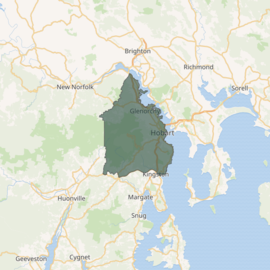
 Division of Denison in Tasmania, as of the 2016 federal election | |
| Created | 1903 |
| Abolished | 2019 |
| Namesake | Sir William Denison |
| Electors | 74,963 (2016) |
| Area | 288 km2 (111.2 sq mi) |
| Demographic | Inner metropolitan |
The Division of Denison was an
Australian electoral division in Tasmania, before being replaced by the Division of Clark as part of a 2016–17 redistribution.[1]
History

The division was one of the five established when the former Division of Tasmania was redistributed on 2 October 1903 and is named for Sir William Denison, who was Lieutenant Governor of Van Diemen's Land 1847–55. It was located in central Hobart on the western shore of the River Derwent. As at the 2016 election (the last election before being replaced by Clark), it incorporated the area covered by the Cities of Hobart and Glenorchy, together with the northern parts of Kingborough Council, including Taroona, generally north of the Huon Highway. kunanyi / Mount Wellington was a prominent physical feature in the division's west. Denison was a consistently marginal seat, but was held by the
independent MP Andrew Wilkie, elected at the 2010 election. Denison has had 16 different members, the second highest (together with Bendigo and Swan, and after Bass's
17) of any federal electorate.
Members
| Image | Member | Party | Term | Notes | |
|---|---|---|---|---|---|

|
Sir Philip Fysh (1835–1919) |
Protectionist | 16 December 1903 – 1906 |
Previously held the Division of Deakin . Retired
| |
| Anti-Socialist | 1906 – 26 May 1909 | ||||
| Liberal | 26 May 1909 – 19 February 1910 | ||||

|
William Laird Smith (1869–1942) |
Labor | 13 April 1910 – 14 November 1916 |
Served as minister under Hughes. Lost seat | |
| National Labor | 14 November 1916 – 17 February 1917 | ||||
Nationalist
|
17 February 1917 – 16 December 1922 | ||||

|
David O'Keefe (1864–1943) |
Labor | 16 December 1922 – 14 November 1925 |
Previously a member of the Senate. Lost seat. Later elected to the Tasmanian House of Assembly seat of Wilmot in 1934 | |

|
Sir John Gellibrand (1872–1945) |
Nationalist
|
14 November 1925 – 17 November 1928 |
Lost seat | |

|
Charles Culley (1877–1949) |
Labor | 17 November 1928 – 19 December 1931 |
Previously held the Denison in 1934
| |

|
Arthur Hutchin (1887–1965) |
United Australia | 19 December 1931 – 15 September 1934 |
Lost seat | |

|
Gerald Mahoney (1892–1955) |
Labor | 15 September 1934 – 21 September 1940 |
Previously held the Denison . Lost seat
| |

|
Arthur Beck (1892–1965) |
United Australia | 21 September 1940 – 21 August 1943 |
Lost seat | |

|
Frank Gaha (1894–1966) |
Labor | 21 August 1943 – 31 October 1949 |
Previously a member of the Denison in 1950
| |

|
Athol Townley (1905–1963) |
Liberal | 10 December 1949 – 24 December 1963 |
Served as minister under Menzies . Died in office
| |

|
Adrian Gibson (1935–2015) |
15 February 1964 – 29 September 1969 |
Retired | ||

|
Robert Solomon (1931–2024) |
25 October 1969 – 2 December 1972 |
Lost seat | ||

|
John Coates (1944–) |
Labor | 2 December 1972 – 13 December 1975 |
Lost seat. Later elected to the Senate in 1980 | |

|
Michael Hodgman (1938–2013) |
Liberal | 13 December 1975 – 11 July 1987 |
Previously a member of the Denison in 1992
| |

|
Duncan Kerr (1952–) |
Labor | 11 July 1987 – 19 July 2010 |
Served as minister under Keating . Retired
| |

|
Andrew Wilkie (1961–) |
Independent
|
21 August 2010 – 11 April 2019 |
Transferred to the Division of Clark after Denison was abolished in 2019 |
Election results
| Party | Candidate | Votes | % | ±% | |
|---|---|---|---|---|---|
| Independent | Andrew Wilkie | 29,372 | 44.07 | +5.99 | |
| Labor | Jane Austin | 15,335 | 23.01 | −1.74 | |
| Liberal | Marcus Allan | 13,267 | 19.90 | −3.33 | |
| Greens | Jen Brown | 7,068 | 10.60 | +2.68 | |
| Christian Democrats | Amanda Excell | 980 | 1.47 | +1.47 | |
| Democratic Labour | Wayne Williams | 632 | 0.95 | +0.10 | |
| Total formal votes | 66,654 | 97.08 | +1.30 | ||
| Informal votes | 2,002 | 2.92 | −1.30 | ||
| Turnout | 68,656 | 92.82 | −1.44 | ||
| Notional two-party-preferred count | |||||
| Labor | Jane Austin | 43,550 | 65.34 | +6.43 | |
| Liberal | Marcus Allan | 23,104 | 34.66 | −6.43 | |
Two-candidate-preferred result
| |||||
| Independent | Andrew Wilkie | 45,176 | 67.78 | +2.27 | |
| Labor | Jane Austin | 21,478 | 32.22 | −2.27 | |
| Independent hold | Swing | +2.27 | |||
References
- ^ "Names and boundaries of federal electoral divisions in Tasmania decided". Australian Electoral Commission. Retrieved 15 December 2018.
- ^ Denison, TAS, Virtual Tally Room 2016, Australian Electoral Commission.
