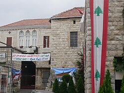
Douma, Lebanon
Douma
دوما Duma | |
|---|---|
 Center of Douma, 2009 | |
| Nickname: Douma al-Hadid (the Iron Douma) | |
| Coordinates: 34°12′N 35°50′E / 34.200°N 35.833°E | |
| Country | |
| Governorate | Mount Lebanon |
| District | Batroun |
| Founded by | Chalhoub clan |
| Government | |
| Elevation | 1,070 m (3,510 ft) |
Douma (
Arabic: دوما, romanized: Dūmā) is a village in Lebanon located 80 km from Beirut, 30 km from Byblos and 45 km from Tripoli. Douma is administratively part of Batroun District
and is known for its location in a valley surrounded by mountains. It stands at an altitude of 1070 m. Almost all of its houses are covered in red tiles. It has a temperate climate and an abundance of vineyards and olive and apple groves.
History
Douma was populated since ancient times. In the town square sits a
Christian clan of the Maalouf.[1] The family continues to inhabit the village until the present day.[1] In 1880 the Ottoman mutasarrif of Mount Lebanon, Rustum Pasha, appointed a municipal council to administer Douma, the sixth locality to receive a council in Mount Lebanon.[2]

The
Sa’dallah al-Jabiri who was destined to become Syria's first Prime Minister after its independence in the 1940s. Another one was a main author of Syria's constitution: lawyer Safadi.[citation needed
]
Name

Douma is also named Dūma al-Hadīd (literally "Douma of iron" or "Iron Douma") due to the abundance of iron found in its soil and the superior craftsmanship of its blacksmiths. The arming industry established under
Choueir to come and settle in Douma since opportunities of work were plentiful at the time.[citation needed
]
Climate
Douma has a Mediterranean climate. Rainfall is higher in winter than in summer. The Köppen-Geiger climate classification is Csa. The average annual temperature in Douma is 15.2 °C (59.4 °F). About 1,210 mm (47.64 in) of precipitation falls annually.
| Climate data for Douma | |||||||||||||
|---|---|---|---|---|---|---|---|---|---|---|---|---|---|
| Month | Jan | Feb | Mar | Apr | May | Jun | Jul | Aug | Sep | Oct | Nov | Dec | Year |
| Mean daily maximum °C (°F) | 10.7 (51.3) |
11.0 (51.8) |
13.8 (56.8) |
18.9 (66.0) |
23.4 (74.1) |
27.2 (81.0) |
29.5 (85.1) |
30.1 (86.2) |
27.2 (81.0) |
23.6 (74.5) |
17.9 (64.2) |
13.3 (55.9) |
20.6 (69.0) |
| Mean daily minimum °C (°F) | 2.8 (37.0) |
3.1 (37.6) |
4.7 (40.5) |
8.1 (46.6) |
11.6 (52.9) |
14.7 (58.5) |
16.4 (61.5) |
17.2 (63.0) |
14.7 (58.5) |
12.3 (54.1) |
8.4 (47.1) |
4.9 (40.8) |
9.9 (49.8) |
| Average precipitation mm (inches) | 265 (10.4) |
222 (8.7) |
202 (8.0) |
87 (3.4) |
35 (1.4) |
2 (0.1) |
1 (0.0) |
1 (0.0) |
9 (0.4) |
43 (1.7) |
124 (4.9) |
219 (8.6) |
1,210 (47.6) |
| Source: Climate-Data.org,Climate data | |||||||||||||
Twin towns
 Digne-les-Bains, France
References
- ^ ISBN 978-0-19-518-111-1.
- ^ "Joseph Khairallah Maalouf - Head of the Municipality of Douma". The Monthly Magazine. 8 March 2014. Retrieved 26 June 2020.
- ^ Kadi, Samar (4 July 2019). "Lebanon's Douma village where Levantine traditions survive". The Arab Weekly. Retrieved 26 June 2020.
External links
- Duma, Localiban


