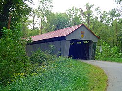
Eakin Mill Covered Bridge
Eakin Mill Covered Bridge | |
 Northern side of the bridge | |
| Location | Mound Hill Rd., Arbaugh, Ohio |
|---|---|
| Coordinates | 39°10′16″N 82°20′13″W / 39.17111°N 82.33694°W |
| Area | less than one acre |
| Built | 1870 |
| Architect | Gilman & Ward Co. |
| Architectural style | King post truss |
| NRHP reference No. | 76001539[1] |
| Added to NRHP | March 16, 1976 |
The Eakin Mill Covered Bridge (also known as the "McLaughlin Bridge" or the "Geer's Mill Bridge") is a historic covered bridge in Vinton County, Ohio, United States. Located southeast of the county seat of McArthur, this bridge carries Mound Hill Road near the community of Arbaugh.[1]
Built in 1870,
With the developments of modern truck transportation, the Eakin Mill Covered Bridge became less well suited to daily operation. Many trucks crossed the bridge while carrying loads heavier than they were permitted to carry, and the bridge sustained significant structural damage; accordingly, it was closed and replaced. Nevertheless, the bridge remains in its original location, and it has been designated a historic site.[2] In 1976, the Eakin Mill Covered Bridge was listed on the National Register of Historic Places,[1] qualifying both because of its historically significant engineering and because of its place in Ohio's history.[3]
References
- ^ a b c d "National Register Information System". National Register of Historic Places. National Park Service. March 13, 2009.
- ^ a b c Owen, Lorrie K., ed. Dictionary of Ohio Historic Places. Vol. 2. St. Clair Shores: Somerset, 1999, 1367.
- ^ Ohio Historical Society, 2007. Accessed 2010-08-08.


