Eastrington
| Eastrington | |
|---|---|
2011 census)[1] | |
| OS grid reference | SE796299 |
| Civil parish |
|
| Unitary authority | |
| Ceremonial county | |
| Region | |
| Country | England |
| Sovereign state | United Kingdom |
| Post town | GOOLE |
| Postcode district | DN14 |
| Dialling code | 01430 |
| Police | Humberside |
| Fire | Humberside |
| Ambulance | Yorkshire |
| UK Parliament | |
Eastrington is a small village and
The civil parish is formed by the village of Eastrington and the hamlets of Newland, Owsthorpe and Portington. According to the

The village is served by Eastrington railway station (formerly "South Eastrington") on the Hull to Selby railway line, and was historically also served by North Eastrington railway station on the Hull and Barnsley Railway.[4]
Nearby Eastrington Ponds was designated a
In 1823 Eastrington was in the
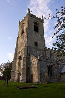
St Michael's Church

St Michael's Church, Eastrington is at the centre of the village. A church at Eastrington is mentioned in the 1086
Architectural evidence suggests that much of St Michael's Church building surviving today was built during the 14th century. The windows of the chapel are typical of the 14th century and a
The church was designated a Grade I listed building in 1966 and is now recorded in the National Heritage List for England, maintained by Historic England.[7]
References
- ^ Office for National Statistics. Retrieved 17 February 2018.
- ^ UK Census (2001). "Local Area Report – Eastrington Parish (00FB041)". Nomis. Office for National Statistics. Retrieved 27 February 2020.
- ^ "Haltemprice and Howden". UK Polling Report. Archived from the original on 18 May 2015. Retrieved 11 May 2015.
- OL 11956311M.
- ^ "Eastrington Ponds" (PDF). East Riding of Yorkshire Council. Retrieved 13 June 2013.
- ^ Baines, Edward (1823). History, Directory and Gazetteer of the County of York. p. 200.
- ^ Historic England. "Church of St Michael (1031835)". National Heritage List for England. Retrieved 12 August 2013.
- Gazetteer — A–Z of Towns Villages and Hamlets. East Riding of Yorkshire Council. 2006. p. 5.
External links
 Media related to Eastrington at Wikimedia Commons
- Eastrington in the Domesday Book
