
Enghien
Enghien
Inguî (Picard) Edingen (Dutch) | |
|---|---|
.jpg) | |
 Coat of arms | |
Location of Enghien  | |
 Enghien Location in Belgium
Location of Enghien in Hainaut PS | |
| Area | |
| • Total | 39.4 km2 (15.2 sq mi) |
| Population (2018-01-01)[1] | |
| • Total | 13,734 |
| • Density | 350/km2 (900/sq mi) |
| Postal codes | 7850 |
| NIS code | 51067 |
| Area codes | 02 |
| Website | www.enghien-edingen.be |
Enghien (West Flemish: Enge) is a city and municipality of Wallonia located in the province of Hainaut, Belgium.
On 1 January 2006, Enghien had a total population of 11,980. The total area is 40.59 km2 (15.67 sq mi), which gives a population density of 295 inhabitants per km2.
The municipality consists of the following districts: Enghien, Marcq, and Petit-Enghien. It is situated on the Flemish border, and restricted language rights are granted to the Dutch speaking minority (so-called language facilities).
History
Enghien gave its name to a French
Princes of Condé
, the famous cadet branch of the French royal family.
In 1566, the county of Enghien was elevated to a
Henry III, Prince of Condé, grandson of Henry II, Prince of Condé, to rename the duchy of Montmorency as "duchy of Enghien
", in memory of the duchy of Enghien which the Princes of Condé had lost in 1569 at the death of Louis I de Bourbon.
The city of
commune of Enghien-les-Bains
in the 19th century.
Image gallery
-
 Town hall
 -
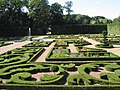
 The Empain château in the Enghien Gardens
 -
-
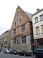 Jonathas House (16th century)


.jpg)

See also
- Qualitis Science Park
References
- ^ "Wettelijke Bevolking per gemeente op 1 januari 2018". Statbel. Retrieved 9 March 2019.
External links
Wikimedia Commons has media related to Enghien.
Places adjacent to Enghien | |
|---|---|
| Ath |  | |
|---|---|---|
| Charleroi | ||
| La Louvière | ||
| Mons | ||
| Soignies | ||
| Thuin | ||
| Tournai-Mouscron | ||
| ||
| International | |
|---|---|
| National | |
| Geographic | |