
Antoing
This article needs additional citations for verification. (October 2021) |
Antoing
Antweon (Picard) | |
|---|---|
 | |
 Flag .svg) Coat of arms | |
Location of Antoing  | |
 Antoing Location in Belgium
Tournai | |
| Government | |
| • Mayor | Bernard Bauwens |
| Area | |
| • Total | 31.33 km2 (12.10 sq mi) |
| Population (2018-01-01)[1] | |
| • Total | 7,760 |
| • Density | 250/km2 (640/sq mi) |
| Postal codes | 7640-7643 |
| NIS code | 57003 |
| Area codes | 069 |
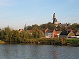
Antoing (French pronunciation: province of Hainaut, Belgium.
The municipality consists of the following districts: Antoing, Bruyelle, Calonne, Fontenoy, Maubray, and Péronnes-lez-Antoing.
History
The
War of Austrian Succession, was fought near Fontenoy
village on 11 May 1745.
Places of interest
- Antoing Castle, originally from the 12th century, restored by Eugène Viollet-le-Duc in the 19th century[2]
-
 Antoing Castle, castle of the Princes de Ligne (13th - 16th centuries)
 -
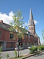 Churchtower (l'église Saint-Pierre)
 -
 Calonne, industrial area along the Scheldt


Famous inhabitants
- Raoul Cauvin, comics writer, was born in Antoing in 1938
References
- ^ "Wettelijke Bevolking per gemeente op 1 januari 2018". Statbel. Retrieved 9 March 2019.
- ^ Ghidrai, George. "Antoing Castle". www.castlesworld.com. Retrieved 2021-08-22.
External links
 Media related to Antoing at Wikimedia Commons
| Ath |  | |
|---|---|---|
| Charleroi | ||
| La Louvière | ||
| Mons | ||
| Soignies | ||
| Thuin | ||
| Tournai-Mouscron | ||
| ||
| International | |
|---|---|
| National | |
| Geographic | |
This Hainaut Province location article is a stub. You can help Wikipedia by expanding it. |