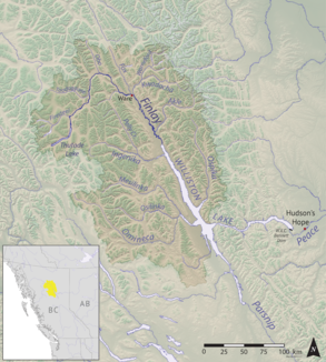
Finlay River
| Finlay River | |
|---|---|
 Map of the Finlay River | |
| Location | |
| Country | Canada |
| Province | British Columbia |
| District | Cassiar Land District |
| Physical characteristics | |
| Source | |
| • location | Thutade Lake |
| • coordinates | 57°04′30″N 126°53′26″W / 57.07513°N 126.89063°W |
| • elevation | 1,200 metres (3,900 ft) |
| Mouth | |
• location | Williston Lake |
• coordinates | 56°53′38″N 124°57′02″W / 56.89397°N 124.95057°W |
• elevation | 700 metres (2,300 ft) |
| Length | 420 kilometres (260 mi) |
| Basin size | 43,000 square kilometres (17,000 sq mi) |
| Discharge | |
| • average | 680 cubic metres per second (24,000 cu ft/s) |
The Finlay River is a 402 km long river in north-central
W.A.C. Bennett Dam in 1968. Prior to this, the Finlay joined with the Parsnip River to form the Peace. The headwaters of the Finlay at Thutade Lake are considered the ultimate source of the Mackenzie River.[1] Deserters Canyon
is located just north of Williston Lake.
The Finlay drains an area of 43,000 square kilometres and discharges at a mean rate of 600 cubic metres per second. Major tributaries of the Finlay include the
Fort Ware, located at the junction of the Finlay and Warneford. Tatlatui Provincial Park protects the area of the Tatlatui Range
, where Thutade Lake is located.
Stickeen Territories (Stikine Territory) which had been formed from the North-Western Territory in response to the Peace and Stikine Gold Rushes
and which was amalgamated with the Colony of British Columbia in the following year.
Tributaries
- Firesteel River
- Toodoggone River
- Fox River
- Kwadacha River
- Paul River
- Akie River
- Ingenika River
- Davis River
- Mesilinka River
- Osilinka River
See also
References
- ^ Atlas of Canada: Rivers of Canada page Archived April 4, 2007, at the Wayback Machine
