
Flamborough, Ontario
A major contributor to this article appears to have a close connection with its subject. (April 2016) |
Flamborough | |
|---|---|
Dissolved town (lower-tier) | |
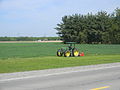
 Freelton farm, looking west on Concession Road 8 East | |
|
EDT ) |
Flamborough is a district and former municipality in the city of
History
Excavations have unearthed evidence of this area’s extensive use by
The Chonnonton Nation lived in the area until they were displaced by the
After the American Revolution in 1783 and the creation of Upper Canada, Treaty No. 3 was established between the Crown and Mississauga Nation in 1792. Soon after, land at the western end of Lake Ontario was surveyed and organized into townships, which included East Flamborough, West Flamborough and Beverly. Governor's Road (also known as Queen's Highway 99 and later Regional Roads 399 and 299) was built on the border with neighbouring Ancaster Township in 1794–95, linking York (later Toronto) and London.
East Flamborough almost had a much different identity. Following the bloody collapse of the
Perhaps the most dramatic event in Flamborough’s modern history occurred during the
In 1816, among fears that the Burlington Heights community would not survive another winter,
.JPG)
The three townships and Waterdown were founding constituents of Wentworth County in 1816. Waterdown was created in 1879 from that part of East Flamborough above the Niagara Escarpment and within approximately a kilometre of King's Highway No. 5. The town of Dundas was created from parts of West Flamborough and Ancaster Townships.

In 1974, Flamborough Township was created by amalgamating the townships of East Flamborough, West Flamborough and Beverly with the village of Waterdown. At the same time, a small portion of Beverly Township near the community of Clyde was ceded to North Dumfries Township and a more populous but smaller portion of East Flamborough near the community of Aldershot was ceded to Burlington. Flamborough became a town in 1985.
In 2001, the provincial government amalgamated Flamborough with Ancaster, Dundas, Glanbrook, and Stoney Creek into the enlarged City of Hamilton.
The amalgamation was bitterly and unsuccessfully protested by some Flamborough residents and those of adjacent communities, particularly since the incumbent Progressive Conservative MPP, Toni Skarica's government had promised in the previous election that the amalgamation would not occur. Skarica resigned in protest, but the amalgamation was not rescinded.
The population of Flamborough at the 2001 census was 37,796. By the 2006 census, its population had increased to 39,220.
Flag and Coat of Arms of Flamborough

|
|
On September 14, 2009, the Flamborough Heritage Society formally petitioned Claire Boudreau, Chief Herald of Canada, for a grant of arms which would ". . . reflect the former Town of Flamborough and its rich heritage so that we can better educate residents in the region." The Chief Herald accepted the petition and assigned Dr. Forrest Pass, Saguenay Herald, to the file.
That fall, the Flamborough Heritage Society created the "Grant of Arms Committee" to work with Dr. Pass to create a suitable design for the community. The first meeting of the Grant of Arms Committee was held on January 2, 2010, in the "Kirk Room" of the Royal Coachman in Waterdown. At this initial meeting four key themes were identified by the committee for representation in the arms and flag: Trees, Water, People and Growth.
Throughout 2010 and 2011 meetings were held across Flamborough in an effort to be as inclusive as possible. Thanks to a partnership with the Flamborough Review, numerous articles were published encouraging people to offer their suggestions to the committee. All schools in Flamborough were encouraged to have their students participate in a contest to create a motto for Flamborough (ultimately created by committee member Kyle Menegaldo after combining submissions from Greensville Public School and Rehoboth Christian School).
The Flamborough Grant of Arms was published in the Canada Gazette (Vol. 145, No. 46) on November 12, 2011. Since early 2016, the original Grant of Arms presented at the Carlisle Golf & Country Club has hung in the Flamborough Archives in the Waterdown Branch of the Hamilton Public Library.[4]

The newsletter of The Waterdown East Flamborough Heritage Society explained in its April 2011 edition:
Arms and flags have a long history in this country, and are important tools used to project identity. Often a community's flag and coat of arms are residents' only reminders of their area's rich history. It was with this idea in mind that a grant of arms committee was struck by the WEFHS in 2009.
Comprised of members from every corner of the historic Flamborough-Beverly region, the committee worked closely with the Canadian Heraldic Authority (and in particular Dr. Forrest Pass, the Herald assigned to the file) to create a symbol that reflected our unique corner of the world, including both its human and natural aspects. After their first gathering in the Dart Room of the Royal Coachman, meetings were held in Rockton, Greensville, Waterdown, Carlisle, Clappisons Corners, Strabane, and Clyde as various symbols were hotly debated. Historic township seals were consulted, as well as previous symbols of the Town of Flamborough. In creating a motto for the community, every school in the area (over 20) were consulted and students were asked to send in their suggestions.[5]
On May 10, 2011, the Flamborough flag was raised over Waterdown District High School in the presence of its student body, as well as a delegation from Allan A. Greenleaf Public School.[6]
Geography and natural attractions
Much of Flamborough is located on top of the Niagara Escarpment; thus the Bruce Trail passes through the area. Although relatively flat in the south, a slow but steady incline is observable until reaching the Wellington County line which is the approximate height of land dividing two watersheds. The Beverly Swamp, located in the western part of the former Beverly Township, is another important physiographic area.
Natural attractions operated by the Hamilton Conservation Authority include:
- Westfield Heritage Centre, a living history museum containing pioneer era buildings moved from other locations across Ontario
- Valens Conservation Area, offering camping and boating at its reservoir[7]
- Christie Lake, swimming and stocked fishing at its reservoir[8]
- Spencer Gorge and Webster's Falls Conservation Area, with views of the falls and city below while hiking on the Bruce Trail.
Waterdown's Souharissen Natural Area
On August 21, 2014, the Souharissen Natural Area was dedicated in Waterdown by
The Souharissen Natural Area covers 27 acres in the Village of Waterdown, and is the result of years of work following the discovery of 104 Indigenous archeological sites in the Waterdown Bay Development Area in 2005.
Along with the Aboriginal sites, the foundations of an early 19th-century dwelling were uncovered in the area. This dwelling may have been used by the first European settlers of Waterdown, Alexander Brown and Merren Grierson. The Natural Area includes a plaque identifying this important landmark, as well as detailing the histories of Merren Grierson and Alexander Brown, that was unveiled by the Lieutenant Governor, Chief LaForme and researcher Kekoa Reinebold.
Later that day a community feast was held in Waterdown at a local residence in honour of the return of the Mississaugas of the New Credit First Nation to Flamborough, as well as the visit by both the Lieutenant Governor of Ontario and Chief of the Mississaugas of the New Credit. Everyone who was part of the dedication, including the Lieutenant Governor and Chief Laforme attended.[9]
Economy and commercial attractions
After early European settlers had cleared the land of pine and oak forests, they began subsistence and then export farming. Disregarding the swamp and the excessively rocky areas of the Mountsberg area, the land is devoted chiefly to agriculture. Much of the arable land is devoted to raising corn, strawberries and cash crops.
In recent decades, Flamborough has become home to commuters and hobby farmers in the Golden Horseshoe. It has easy access to secondary highways, especially with the opening of an interchange with Highway 403 at Waterdown Road, granting easier access for traffic to/from Toronto.[10]
Notable attractions operated as commercial enterprises include:
- African Lion Safari, with land mammals and birds of prey in an open air zoo
- Flamboro Downs, featuring harness racing, and slot machines
- car racing
- Sailplaneaerodrome, offering flight training and visitor rides.
- Rockton World's Fair, an agricultural exhibition held every Thanksgiving Weekend (Canadian)
Local Media
The Flamborough Review [1] is a community newspaper published every Thursday by Metroland Media. Metroland acquired the Review in 2003.
Gallery
-
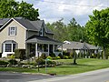
 Freelton Farmhouse
 -
 Carlisle
 -
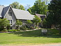 Anglican Christ Church
 -
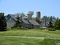
 Barn in West Flamborough
 -
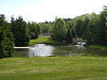
 Christie Lake
 -
 Clappison's Corners
 -
 Copetown
 -
 Farms in Flamborough
 -
 Freelton
 -
 Greensville
 -
 Greensville
 -
 Millgrove
 -
 Millgrove, Millgrove General Store
 -
 Farm in Flamborough
 -
 Freelton, Roman Catholic Church


.JPG)
.JPG)
.JPG)


.JPG)

See also
References
- ^ Tidridge, Nathan. The Extraordinary History of Flamborough, including the Village of Waterdown. Waterdown:Flamborough Heritage Society, 2015.
- ^ "Souharissen Natural Area, Waterdown".
- ^ Tidridge, Nathan. The Extraordinary History of Flamborough, including the Village of Waterdown. Waterdown:Flamborough Heritage Society, 2015.
- ^ Cornish, Dianne. "Flamborough's coat of arms unveiled". The Hamilton Spectator. Flamborough Review. Retrieved 6 August 2011.
- ^ Tidridge, Nathan. "Mr" (PDF). The Waterdown East Flamborough Heritage Society. Retrieved 7 August 2011.
- ^ Tidridge, Nathan. "Mr. Tidridge's Website". WDHS. Archived from the original on 8 October 2011. Retrieved 6 August 2011.
- ^ Valens Conservation Area
- ^ Christie Lake
- ^ "Souharissen Natural Area, Waterdown".
- ^ "Waterdown Road Interchange". Archived from the original on 2010-08-11. Retrieved 2011-01-13.
External links
43°20′46″N 80°03′18″W / 43.346°N 80.055°W
| International | |
|---|---|
| National | |
| Geographic | |