
Forry's Mill Covered Bridge
Forry's Mill Covered Bridge | |
|---|---|
Burr arch truss | |
| Total length | 103 feet (31.4 m) |
| History | |
| Constructed by | Elias McMellen |
| Construction start | 1869 |
| Location | |
 | |
The Forry's Mill Covered Bridge is the last covered bridge that spans Chiques Creek in West Hempfield in Lancaster County, Pennsylvania, United States.[1] A county-owned and maintained bridge, its official designation is the Big Chiques #7 Bridge.[2] (Chiques Creek was known as Chickies Creek until 2002).[3]
The bridge has a single span, wooden, double
The bridge's WGCB Number is 38-36-28.[4] In 1980 it was added to the National Register of Historic Places as structure number 80003512.[5] It is located at 40°4′3.6″N 76°28′40.8″W / 40.067667°N 76.478000°W (40.06767, -76.47800).[6]
Forry's Mill Covered Bridge is located in West Hempfield Township[7] on Bridge Valley Road 0.4 km (0.25 mi) north of Pennsylvania route 23 5.5 km (3.4 mi) east of Marietta,[1] less than a mile away from the former site of the Siegrist's Mill Covered Bridge.[7]
History
Forry's Mill Covered Bridge was originally built in 1869 by Elias McMellen[1] for a cost of $2969. The bridge required repairs in 1925 to its sides and floor.[7]
Dimensions
- Length: 91 span and 103 feet (31 m) total length[4]
- Width: 12 feet 10 inches (3.91 m) clear deck and 15 feet (4.6 m) total width[4]
- Overhead clearance: 11 feet 6 inches (3.51 m)[1]
- Underclearance: 12 feet (3.7 m)
Gallery
-
 Wide view of the side of the bridge
 -
 A closeup of the side of the bridge
 -
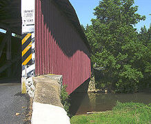
 One of the approaches to the bridge
 -
 Inside of the bridge showing theBurr arch trussdesign
 -
 The underside of the bridge
 -
 A view of the bridge from the air
 -
 A side view of the bridge from the air


See also
- Burr arch truss
- List of Lancaster County covered bridges
References
- ^ a b c d Bickel, Hank (2005-06-23). "Forry Mill Bridge". Covered Bridges of the Northeast USA. Retrieved 2006-08-04.
- ^ a b c "Forry's Mill Covered Bridge". Lancaster County, PA Government Portal. County of Lancaster, Pennsylvania. 2001-10-30. Archived from the original on 2007-09-27. Retrieved 2006-07-07.
- ^ Geographic Names Information System, United States Geological Survey (August 30, 1990). "Geographic Names Information System Feature Detail Report: Chiques Creek". Retrieved 2006-09-05.
- ^ a b c Dr. Roger A. McCain. "Forry's Mill Bridge". A Guide to Old Covered Bridges of Southeastern Pennsylvania and nearby areas. Archived from the original on 2006-09-09. Retrieved 2006-08-03.
- ^ "PENNSYLVANIA - Lancaster County". National Register of Historic Places. Archived from the original on 2016-03-03. Retrieved 2007-03-20.
- ^ Travis, Dale. "38-36-28". Round Barns & Covered Bridges. Retrieved 2006-08-08.
- ^ a b c "Forry's Mill Covered Bridge". Lancaster County Pennsylvania Dutch Country Official Visitors Center. Pennsylvania Dutch Convention & Visitors Bureau. 2006. Retrieved 2006-07-07.
