
Fort Brown
Fort Brown | |
 Period map of Fort Brown in the park exhibit. | |
 Fort Brown  Fort Brown | |
| Location | S edge of Brownsville off International Blvd., Brownsville, Texas |
|---|---|
| Coordinates | 25°53′54″N 97°29′32″W / 25.89833°N 97.49222°W |
| Area | 20 acres (8.1 ha) |
| Built | 1846 |
| NRHP reference No. | 66000811[1] |
| Significant dates | |
| Added to NRHP | October 15, 1966 |
| Designated NHLD | December 19, 1960[2] |
Fort Brown (originally Fort Texas) was a military post of the
Early years
In 1846, Captain Joseph K. Mansfield[3]: 40 directed the construction of a star-shaped earthwork for 800 men called "Fort Texas" on the northern side of the Rio Grande, "by the order from General [Zachary] Taylor to command the city of Matamoros" south of the river.[4]
The next year, the fort was besieged during the opening of the Mexican–American War. During the Siege of Fort Texas, two Americans were killed, including Major Jacob Brown and George Oakes Stevens (of Vermont) of the 2nd Dragoons. In honor of the fallen major, General Taylor renamed the post as Fort Brown. In 1849, the city of Brownsville, Texas, was established not far from the fort's grounds, after the United States had acquired Texas following the war.
Cortina
While in command at the fort, Major Samuel P. Heintzelman coordinated with John Salmon Ford in the Cortina Troubles, culminating in the Battle of Rio Grande City in 1859.
Civil War
In 1861, Confederate
Postbellum
From 1867–1869, a permanent US Army fort was constructed under the supervision of Capt. William A. Wainwright. In 1882, Dr.
Brownsville raid
A unit of African-American soldiers, known as
In 1972, the Army conducted another investigation, led by Lt. Col. William Baker. The government concluded that the Black soldiers had not been responsible. They were given posthumous honorable discharges, but by then, only two of the original 168 men were still alive. The two men received compensation, but the Army did not restore the dead soldiers' pensions, to which their descendants would have been entitled.
Since the late 20th century, historians have speculated about the incident.
First airplane to be attacked by hostile fire
On April 20, 1915, U.S. Signal Corps Officers Byron Q. Jones and Thomas Millings flew a Martin T over the fort to spot movements of Mexican Revolutionary leader Francisco "Pancho" Villa. The plane reached an altitude of 2,600 ft. and was up for 20 minutes. It did not cross the border into Mexico, although it was fired upon by machine guns and small arms. These frequent patrols lasted for 6 weeks and were used more effectively in 1916.
124th Cavalry
The troopers stationed at Fort Brown from 1929–45 were from the
United States Army Air Forces use
During World War II, Fort Brown was transferred to the USAAF Training Command on July 7, 1943. The USAAF Gulf Coast Training Center (later Central Flying Training Command) used the fort for flexible gunnery training until the fort was inactivated on February 1, 1946.[7]
Decommission
On February 1, 1946, Fort Brown was decommissioned and turned over to the Army Corps of Engineers on April 25, 1946. It was acquired by the City of Brownsville and Texas Southmost College in 1948.
Three areas that were once part of the post were designated a discontiguous National Historic Landmark District in 1960, in recognition of its historic importance. These include earthworks built in 1846, a cavalry barracks built in 1848, and a collection of buildings erected mainly between 1868 and 1870, including a hospital, morgue, barracks, commissary, colonel's house, and officers' quarters.[8]
The Consolidated Appropriations Act, 2023 authorized the addition of Fort Brown (166 acres) to Palo Alto Battlefield National Historical Park.[9]
Gallery
-
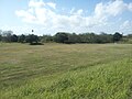 Remnants of the Fort Brown earthworks form the boundary of the Fort Brown Memorial Golf Course and the driving range.
 -
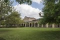 Some of the buildings at Fort Brown
 -
 Champion Hall, which served as the medical laboratory and isolation ward until World War I
 -
 Monument to the fallen Maj. Brown
 -
 Texas historical marker
 -
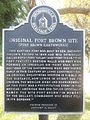
 Texas historical marker commemorating the siege
 -
 Texas historical marker explaining the dimensions of the fort


See also
- List of National Historic Landmarks in Texas
- National Register of Historic Places listings in Cameron County, Texas
- Recorded Texas Historic Landmarks in Cameron County
References
- Fort Brown, Handbook of Texas Online
- ^ a b "National Register Information System". National Register of Historic Places. National Park Service. July 9, 2010.
- ^ Staff (June 2011). "National Historic Landmarks Program: Listing of National Historic Landmarks by State, Texas" (PDF). National Park Service. Retrieved January 10, 2018..
- ISBN 0803261071
- ^ a b Ashcroft, A.C., 1963, "Fort Brown, Texas, in 1861," in Texas Military History, A Quarterly Publication of The National Guard Association of Texas, Vol. 3, Winter, 1963, No. 4, pp. 246–247
- ^ ISBN 0292770340
- ISBN 9780813030197.
- ^ "NHL nomination for Fort Brown". National Park Service. Retrieved January 4, 2018.
- ^ "Fort Texas / Fort Brown – Palo Alto Battlefield National Historical Park (U.S. National Park Service)". National Park Service. Retrieved December 28, 2022.
External links
![]() Media related to Fort Brown at Wikimedia Commons
Media related to Fort Brown at Wikimedia Commons

| Flying training |
|  | ||||
|---|---|---|---|---|---|---|
| Technical training |
| |||||
Municipalities and communities of Cameron County, Texas, United States | ||
|---|---|---|
| Cities |  | |
| Towns | ||
Village | ||
| CDPs |
| |
| Other communities | ||
| Ghost towns | ||
| ||
| International | |
|---|---|
| National | |