
Fort Howard (Wisconsin)
.jpg)
44°31′N 88°1′W / 44.517°N 88.017°W Fort Howard was a 19th-century
History
Along with
During an outbreak of malaria in 1820, the garrison moved to Camp Smith[3] on higher ground nearby. Fort Howard was reoccupied two years later. Abandoned again in 1841, when the garrison was sent to Florida during the Seminole Wars, the fort was officially decommissioned in 1853.
In 1863, the United States government granted land to the States of Michigan and Wisconsin for construction of a military road between Fort Howard and Fort Wilikins near Copper Harbor, Michigan. This road was completed in 1872.[4]
Following the fort's closure its buildings fell into decay. Several structures were subsequently removed to the Camp Smith site, where they are now part of the Heritage Hill State Historical Park. Three of the fort's remaining structures are listed on the National Register of Historic Places: the hospital, hospital ward, and officers' quarters.
Later use of name
In the 20th century, the Fort Howard Paper Company was a pulp and paper manufacturer based in Green Bay, founded by Austin E. Cofrin in 1919. It merged with James River in 1997 to form Fort James Corporation and became part of Georgia-Pacific in 2000.
Images
-
 Kitchen
 -
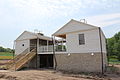
 Hospital during 2014 restoration
 -
 Dining area in Officers' Quarters
 -
 Side of Officers' Quarters
 -
 Looking southeast at courtyard
 -
 Looking northwest across courtyard
 -
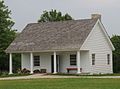 School
 -

-
 Guard house during 2014 reconstruction


Notes
- ^ Fort Edward August
- ^ Evans, William L. "The Military History of Green Bay". Retrieved 21 December 2018.
- ^ "Camp Smith (Wisconsin)". Geographic Names Information System. United States Geological Survey, United States Department of the Interior.
- ^ Ashley, Alex. "The Military Road". Retrieved 6 November 2022.