
Fort Mitchell, Alabama
Fort Mitchell | ||
|---|---|---|
ZIP code 36856[1] | ||
| Area code | 334 | |
| GNIS feature ID | 118523[2] | |
Fort Mitchell is an unincorporated community in Russell County, Alabama, United States. The settlement developed around a garrisoned fort intended to provide defense for the area during the Creek War (1813–14).[3]
Fort Mitchell is about 10 miles south of Phenix City, Alabama and Columbus, Georgia; Fort Moore lies on the opposite side of the Chattahoochee River from Fort Mitchell.
The community is the home of the Fort Mitchell National Cemetery, established in 1987 for interment of all US veterans.[4]
Landmarks
History
A major
Hiawassee .[5]
Notable people
- brigadier general
- Muskogee Creek, who was the first principal chief of the tribe, then located in Indian Territory, after the Civil War
- Creek Indians(1821-?)
See also
Gallery
Below are photographs taken in Fort Mitchell as part of the
Historic American Buildings Survey
:
-
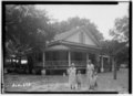 Crowell-Cantey-Alexander House
 -
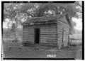
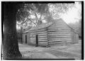 Old slave house, beside Crowell-Cantey-Alexander House
 -
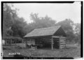 Wood shed, behind Crowell-Cantey-Alexander House
 -
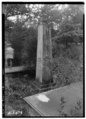 Monument to Col. John Crowell Sr., at Crowell-Cantey-Alexander House
 -
 Old post office
 -
 Old Irish gardener house


References
- ^ "Fort Mitchell ZIP Code". zipdatamaps.com. 2022. Retrieved November 11, 2022.
- ^ "Fort Mitchell". Geographic Names Information System. United States Geological Survey, United States Department of the Interior.
- ^ "RCH". Rcala.com. Retrieved June 9, 2014.
- ^ National Cemetery Administration. "Fort Mitchell National Cemetery - National Cemetery Administration". Cem.va.gov. Retrieved June 9, 2014.
- ^ Wesley, Edgar Bruce (1935). Guarding the frontier. The University of Minnesota Press, p. 38.
Municipalities and communities of Russell County, Alabama, United States | ||
|---|---|---|
| City |  | |
| Town | ||
| CDP | ||
| Unincorporated communities | ||
| Former city | ||
| Footnotes | ‡This populated place also has portions in an adjacent county or counties | |
| ||
| Central cities/largest cities |  Columbus, Georgia Metropolitan Statistical Area Auburn, Alabama Metropolitan Statistical Area Tuskegee, Alabama Micropolitan Statistical Area (defunct) | |
|---|---|---|
| Cities in Georgia | ||
| Cities in Alabama | ||
| Counties in Georgia | ||
| Counties in Alabama | ||
| International | |
|---|---|
| National | |
| Other | |
This Russell County, Alabama state location article is a stub. You can help Wikipedia by expanding it. |