
Garagoa
Garagoa | |
|---|---|
 Church of Garagoa | |
 Flag  Seal | |
 Location of the town and municipality of Garagoa in Boyacá Department | |
| Coordinates: 5°04′57″N 73°21′51″W / 5.08250°N 73.36417°W | |
| Country | Colombia |
| Department | Boyacá |
| Province | Neira |
| Founded | 5 October 1809 |
| Government | |
| • Mayor | Fabio Augusto Arévalo (2020-2023) |
| Area | |
| • City | 191.75 km2 (74.04 sq mi) |
| Elevation | 1,650 m (5,410 ft) |
| Population (2015) | |
| • City | 16,944 |
| • Density | 88/km2 (230/sq mi) |
| • Urban | 13,654 |
| Time zone | -5 |
| Website | Official website |
Garagoa (Spanish pronunciation: [ɡaɾaˈɣoa]) is a town and municipality in Colombia, located in the Boyacá Department. It covers an area of 191.75 km2 and the urban centre is located at an altitude of 1,650 metres (5,410 ft) above sea level. Parts of the municipality reach altitudes of 3,050 metres (10,010 ft). It is the capital of the province of Neira. It is also the seat of the Diocese of Garagoa of the Catholic Church. The municipality is situated in the Eastern Ranges of the Colombian Andes and borders Chinavita in the north, Macanal in the south, Tenza and Sutatenza in the west and Miraflores and Chinavita in the east.[1]
Etymology
Garagoa in Chibcha means "Behind the hill" or "On the other side of the hill".[1][2]
History
In the times before the
Economy
Main economical activities of Garagoa are
Trivia
- The tree frog Dendropsophus garagoensis has been found in and named after Garagoa[3]
Gallery
-
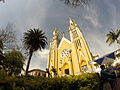 Church of Garagoa
 -
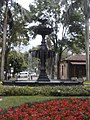 Fountain
 -
 Central park and square
 -
 Tree in central park
 -
 Central park


References
- ^ a b c d (in Spanish) Official website Garagoa
- ^ (in Spanish) Etymology Municipalities Boyacá - Excelsio.net
- ^ Dendropsophus garagoensis