
Gediminas Avenue

Gediminas Avenue (
Named after the
History
The street, built in 1836, was initially known as St. George Avenue,
A portion of the avenue from the Vilnius Cathedral to Vincas Kudirka Square was thoroughly reconstructed before the celebration of the 750th anniversary of Mindaugas' coronation in 2003. The reconstructions included building an underground parking facility – the first such in Lithuania - under the Municipality Square and renovation of all kinds of pipelines and communication cables under the street. Over 100 new trees were planted. During the excavations a few archaeological findings were found and are now on display in the parking garage. Other sections of the avenue were also reconstructed; this work was completed in 2009.
Gallery
-
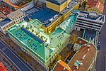
 GO9 Mall
 -
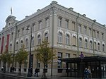
 Bank of Lithuania
 -
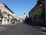 Gedimino Avenue
 -
 At night
 -
 "Gedimino 9" Shopping Centre
 -
 Gedimino 22
 -
 Bank of Lithuania
 -
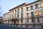 LMTA Palace
 -

-
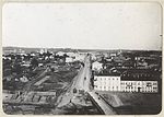 Saint George prospectus (1900)
 -
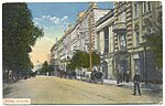 Prospectus (1912)


See also
- Former Jabłkowski Brothers department store in Mickiewicz Street in Vilnius
| History | |||
|---|---|---|---|
| Elderships | |||
| Government | |||
| Transport | |||
| Education | |||
| Landmarks | |||
54°41′14″N 25°16′40″E / 54.68722°N 25.27778°E