
Gemlik
Gemlik | |
|---|---|
District and municipality | |
 | |
 Map showing Gemlik District in Bursa Province | |
 Gemlik Location in Turkey  Gemlik Gemlik (Marmara) | |
| Coordinates: 40°25′54″N 29°09′22″E / 40.43167°N 29.15611°E | |
| Country | Turkey |
| Province | Bursa |
| Government | |
| • Mayor | Mehmet Uğur Sertaslan (CHP) |
| Area | 401 km2 (155 sq mi) |
| Elevation | 22 m (72 ft) |
| Population (2022)[1] | 120,245 |
| • Density | 300/km2 (780/sq mi) |
| Time zone | UTC+3 (TRT) |
| Postal code | 16600 |
| Area code | 0224 |
| Website | www |
Gemlik is a municipality and district of Bursa Province, Turkey.[2] Its area is 401 km2,[3] and its population is 120,245 (2022).[1] It is located in the east of the Gulf of Gemlik. It is approximately 29 km (18 mi) away from Bursa. In antiquity, Gemlik was the location of the ancient Greek town of Cius.
Gemlik is an industrial port and it has a freezone trade center. There are also important industrial establishments in south and west of the harbors. The port of Gemlik is one of the busiest import harbors in Turkey. Gemlik is renowned for black olives.
Etymology
In the
As of 1920, the British were calling Gemlik, Geumlek in publications.[4]
History
Ancient history
Gemlik was the site of the ancient Greek city of Cius
Cius was taken by the
There are coins of Cius, with the legend Κιανων, belonging to the Roman imperial period; and there are coins of Prusias with the epigraph, Προυσιεων των προς θαλασσαν.
Cius became an early Christian
Modern history
From 1867 until 1922, Gemlik was part of Hüdavendigâr vilayet. In 1891, there were 5147 people lived in town center including; 4620 Greeks, 242 Turks, 178 foreigner and 107 Armenian.[7] As of 1920, Gemlik was estimated to have a population of 5,000 (. At that time, it had a naval yard that was no longer in use.[4] On 11 September 1922, Gemlik's remaining Greek citizens left Gemlik to Greece due to population exchange between Turkey and Greece.
Geography
Gemlik was built on a plain which is bordered on three sides by mountains, with the
The Gulf of Gemlik, often called fig port of Kilyos (in reference to the ancient name of the town), is 35 km from east to west, 10–15 km from north to south, and 100–150 meters deep. For many years, this gulf had been used for docking ships, but now it serves as a tourist attraction.
The largest river in the area is Karsak, gurgles from İznik Lake and spilles to Gulf of Gemlik.
In rural areas of Gemlik District mostly covered by olive trees and pines on the Samanlı Mountains.
Composition
There are 35
- Adliye
- Ata
- Balıkpazarı
- Büyükkumla
- Cihatlı
- Cumhuriyet
- Demirsubaşı
- Dr.Ziya Kaya
- Engürücük
- Eşref Dinçer
- Fevziye
- Fındıcak
- Gençali
- Güvenli
- Halitpaşa
- Hamidiye
- Hamidiyeköy
- Haydariye
- Hisar
- Karacaali
- Katırlı
- Kayhan
- Küçükkumla
- Kumla
- Kurşunlu
- Kurtul
- Muratoba
- Narlı
- Orhaniye
- Osmaniye
- Şahinyurdu
- Şükriye
- Umurbey
- Yeniköy
- Yenimahalle
Climate
Gemlik has a hot-summer Mediterranean climate (Köppen climate classification: Csa) with cool and rainy winters, and hot and dry summers. The driest month is July with an average of 22 mm (0.87 in) of rainfall. The wettest month is December with an average of 98 mm (3.9 in) of precipitation. Although a Mediterranean climate generally prevails in the district of Gemlik, the higher elevations have an Oceanic climate (Köppen climate classification: Cfb). The record high temperature is 42.6 °C (109 °F) and the record low temperature is −10.0 °C (14 °F). The annual precipitation ranges between 456.2 mm (17.96 in) and 1,217.4 mm (47.93 in). There are an average 113 days with precipitation. The warmest month of the year is July, with an average temperature of 23.3 °C (74 °F). The coldest month of the year is January, with an average temperature of 5.8 °C (42 °F). [9]
Administration and Politics
Local Elections
| Mayors of Gemlik | |||
|---|---|---|---|
| Yıl | Belediye Başkanı | Parti | Oy Oranı |
| 1977 | İbrahim Akıt | AP | %55,58 |
| 1984 | İsmail Hakkı Çakır | ANAP | %37,90 |
| 1989 | Nezih Dimili | SHP | %29,66 |
| 1994 | Nurettin Avcı | ANAP | %27,95 |
| 1999 | Mehmet Turgut | FP | %24,28 |
| 2004 | Mehmet Turgut | AK Parti | %32,46 |
| 2009 | Fatih Mehmet Güler | CHP | %32,40 |
| 2014 | Refik Yılmaz | AK Parti | %38,80 |
| 2019 | Mehmet Uğur Sertaslan | CHP | %47,25 |
Tourism
Kumla is one of the busiest resorts in Marmara in summer period. Especially people from Istanbul prefer to take their holidays in Kumla because it is one of the nearest resorts to Istanbul. There are also smaller resorts like Büyükkumla, Karacaali and Narlı along the north coast of the gulf. Road to these resorts split from Yalova-Bursa state road to Gemlik beltway through Kumla. Sudüşen waterfall is in the north of the village of Haydariye. There is also a moto-cross tournament organised at Şahintepe point on the Samanlı Mountains and Olive Festival at city in August–September.
Economy
This section may contain an excessive amount of intricate detail that may interest only a particular audience. |
Industrial establishments that produce plastic, textile, marble, chemistry, machinery, automotive, steel and fertilizers continue their activities in the district. Large-scale industrial facilities in Gemlik are concentrated on the western coastline of the district, especially in and around the free zone.
80% of the population living in the district center is engaged in trade. Salt olive, oil, soap trade is the leading. Olive production has an important place in Gemlik industry.
Turkey's first cannery Rifat Minaret Koller. Sti. In parallel with the establishment of canning, vegetable growing has developed. Bean, artichoke, cucumber, tomato, pea, eggplant, pepper are the leading vegetables grown.
A significant portion of the economic revenues are from the agriculture and industry sectors. Olive production; Although it has a large share in terms of the area it covers, it has a high share in terms of economic input it provides in agricultural production. The production is not only consumed in domestic markets, but also exports. There are 2 small industrial sites in the district. 664 workplaces operate in industrial sites. There are also 1 free zone and 2 small industrial sites in Gemlik. There are 87 companies in the free zone, 64 domestic, 11 foreign and 12 domestic-foreign partners. 9937 workers work in the Free Zone.
In 2017 the region from Turkey TL 285,933,564.63. While there TL 282,535,527.42 in 2018 the volume of transactions, the region from Turkey in 2017 to various parts of TL 146,881,502.72. In 2018, 184,858,595.49 TL trading volume occurred. Transaction volume change rate has been realized as (+25,86). When Free Zone Trade data is analyzed, in the same period, from abroad to the region in 2017, 430.902.457,11 TL. In 2018, 515.423.870,72 TL. input is provided. The rate of change during this period was (+19.61). Bursa Free Zone has a trade volume of 1,918,150,680.25 ($) dollars. 12.263.822.782,51 ($) of this amount consists of exports, and 8.457.276.393,26 ($) part of it imports.
The tax collection of the Customs Directorate for 2017 is 376.190.027 TL, and the 2018 tax collection is 466.696.342 TL. The annual rate of change is 24.06. The VAT collection for 2017 is 3.787.643.808 TL, the VAT collection for 2018 is 4.235.680.882 TL. The annual rate of change is 11.83. A total of 245.820.971 TL in 2017–2018. antidamping tax has been obtained. While a fine of 151,070,873 TL was applied in 2017, a fine of 111,104,167 TL was imposed in 2018.
The data of the ports in the district in 2018 are shown in the table below. There are 5 ports in Gemlik. 223 incoming ships, 214 outgoing ships; There are 31 incoming passengers, 53 outgoing passengers and 26,928 incoming vehicles, 31,223 outgoing vehicles.
The total number of taxpayers in the district is 34,576, Tax Accrual is 695,593,681 TL. Tax collection is 375.865.977 TL. d. The Collection / Accrual ratio is 54.04.
There are 2 artisan rooms in Gemlik. The number of members registered in the chambers of trades is 3.227. In addition, there is 1 Commodity Exchange and the number of registered members is 223.
In the district, besides large industrial facilities such as the under construction
A total of 25,000 people work in the free zone, of which 15,000 are employed, and other industrial facilities are 10,000.
Automotive, iron-steel, electric-electronic, textile and marble are among the most exported sectors. The most exported countries are Germany, Romania, Spain, France and England.[10]
Health
There are 2 hospitals in Gemlik: 1 State Hospital and 1 Private Hospital. There are 260 beds in the State Hospital and 7 267 beds in the Private Hospital. There are 9 Family Health Centers and 4 Health Houses.
There are 109 Doctors in the State Hospital, 59 GPs, 50 Specialist Doctors. In addition, 8 Dentists work. The number of people per doctor is 990. The number of beds per 10,000 people is 38. There are 4 ambulances in 112 Emergency Call Centers in the district and 5 in the hospital.
While the number of beds in 2016 and 2017 in our district State Hospital was 128, it was 260 in 2018. The number of inpatients is 10059 in 2018 and the total number of surgeries in 2018 is 9531. While the normal birth in our district was 91 in 2016, 34 in 2017, 92 in 2018, birth by cesarean in 2016 was 193, 106 in 2017 and 92 in 2018. 0–1 year old infant death is 2.
As of 2018, the hospital has 41 polyclinics, 40 normal and 1 emergency, and 34 Family Physicians.
A total of 159 suicide cases occurred in the district, 28 in 2016, 60 in 2017 and 71 in 2018. In 2017, there was an increase of more than a hundred percent in cases of crude suicide compared to 2016. This number increased to 71 in 2018.
Cigarette inspections are carried out periodically by the related commission and in line with the incoming notifications. Administrative fines related to smoking are given to business owners who act against the legislation.[11]
Media and Press
- Gemlik Haberci (Gemlik's first news site)
- Gemlik Gazetesi (first newspaper in Gemlik-1958)
- Gemlik Haber Gazetesi (daily paper)
- Gemlik Körfez Gazetesi (first daily paper in Gemlik)
- Gemlik Gündem Gazetesi (daily paper)
- Gio Detay Dergi (monthly news actual magazine)
- Gemlik Life (digital paper of Gemlik)
- Gemlik Haber (internet news)
Sports
Sport Clubs in Gemlik
- Gemlik Basketbol (Turkey 1 lig )
- Gemlikspor(football)
- Umurspor
- Körfezspor(football)
- Zeytinspor(basketball)
- Gücümspor(basketball)
- Çotanakspor(football)
- Karadenizspor(football).
Gallery
-
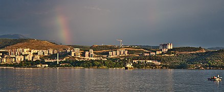 View of Hisartepe from Manastir
 -
 TCG Gemlik docked on Pier
 -
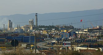 Industrial Zone
 -
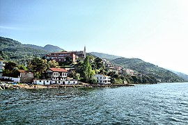 Kurşunlu
 -
 A fishermen shelter in Kurşunlu
 -
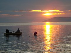 Two fishermen on a boat in the gulf
 -
 Mount Gürle

.jpg)


Notable natives
- Rebetikasinger and composer
- Celal Bayar (1883–1986), 3rd President of the Republic of Turkey. Born in town of Umurbey.
Sister cities
This section needs additional citations for verification. (March 2015) |
 Lauderhill, Florida, United States,
 Novadari, Romania
References
- ^ TÜİK. Retrieved 12 July 2023.
- ^ Büyükşehir İlçe Belediyesi, Turkey Civil Administration Departments Inventory. Retrieved 12 July 2023.
- ^ "İl ve İlçe Yüz ölçümleri". General Directorate of Mapping. Retrieved 12 July 2023.
- ^ a b Prothero, G.W. (1920). Anatolia. London: H.M. Stationery Office.
- ISBN 978-0-415-11935-1.
- ISBN 9786055112158. Retrieved 26 June 2023.
- ^ "Tarihçe". gemlik.gov.tr. Retrieved 7 February 2020.
- ^ Mahalle, Turkey Civil Administration Departments Inventory. Retrieved 12 July 2023.
- ^ "Coğrafi Konumumuz".
- ^ "Ekonomik Durumu". gemlik.gov.tr. Retrieved 8 February 2020.
- ^ "Sağlık Durumu".