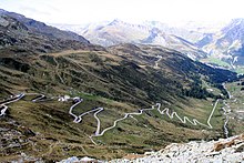
Geography of Lombardy
This article needs additional citations for verification. (May 2019) |

Lombardy's northern border is between the Valtellina and the valleys of the Rhine and the Inn. To the east, Lake Garda and the Mincio separate Lombardy from the other Italian regions, as does the Po in the south with the exception of the Mantuan and Pavese Oltrepò (lit. Beyond the Po). The western boundary is formed by the Lake Maggiore and the Ticino, except the Lomellina.
Landscape

Mountains make up 40 % of Lombardy's area. The
The Lombard Alps are all named after the ancient peoples who dwelled in them in the time of the
To the west of Lake Maggiore and the east of Lake Garda are the Lombard Prealps, whose peaks average at a little over 2,500 metres (8,200 ft). They are made up primarily of calcerous sediments, which allowed glaciers to carve their many valleys and rivers now contained within. These glaciers also made the moraines that form the hilly terrain, making up 12.4% of the region, that connect the Prealps to the plains below.
Mountainous areas

- Lepontine Alps (Adula Alps)
- Lugano Prealps (Comasche Prealps, Varese Prealps)
- Bernina Alps, Livigno Alps, Sesvenna Alps)
- Southern Rhaetian Alps (Ortler Alps, Adamello-Presanella Alps)
- Bergamasque Alps and Prealps (Bergamasque Alps, Bergamasque Prealps)
- Brescian Prealps, Garda Mountains)
- Ligurian Apennines]
Mountains
Alpine passes

Lombardy's alpine valleys are broader and deeper than those found in nearby Piedmont and the Aosta Valley. Because of their size, and in spite of their high altitude, the valleys of Lombardy are very accessible. Traffic through these passes has thus been constant in the region's history, especially commercial traffic.[1]
The most important of these passes are those that connect Lombardy to Switzerland; the Splügen, Maloja, and the Bernina Passes, the latter two mostly within Swiss borders. Likewise, but intranationally, are the Stelvio and Tonale Passes between Lombardy and the Trentino.[1]
Citations
- ^ a b "Lombardia in Italia". bellezzeditalia.it (in Italian). Retrieved 27 November 2017.
