
Lake Garda
| Lake Garda | ||
|---|---|---|
  .jpg)     Clockwise from top: Primary inflows Sarca | | |
| Primary outflows | Mincio | |
| Catchment area | 2,350 km2 (910 sq mi) | |
| Basin countries | Italy | |
| Max. length | 51.6 km (32.1 mi) | |
| Max. width | 16.7 km (10.4 mi) | |
| Surface area | 369.98 km2 (142.85 sq mi) | |
| Average depth | 136 m (446 ft) | |
| Max. depth | 346 m (1,135 ft) | |
| Water volume | 50.35 km3 (40,820,000 acre⋅ft) | |
| Residence time | 26.8 years | |
| Shore length1 | 158.4 km (98.4 mi) | |
| Surface elevation | 65 m (213 ft) | |
| Islands | 5 (incl. Isola del Garda, Isola San Biagio) | |
| Settlements | See article | |
| 1 Shore length is not a well-defined measure. | ||
Lake Garda (
Etymology
In Roman times the lake was known as Benacus and by some it was revered as god Benacus, the personification of the lake, sometimes associated with the cult of Neptune. Today it is better known as Lake Garda, a toponym of Germanic origin attested since the Middle Ages and deriving from that of the homonymous town on the Veronese shore of the lake, which, together with another famous locality of the lake, Gardone Riviera, and others less known – such as Gàrdola, Gardoncino, Gardoni, Guàrdola and Le Garde – testifies the Germanic presence in the area that goes from the 6th to the 8th century CE, in particular, the Lombard one. The name Garda is evolved from the Germanic word warda, meaning "place of guard", "place of observation" or "place of safety".[1]
The classic toponym of the lake, or Benācus lacus (Benaco), is almost certainly of Celtic origin, therefore prior to romanization, and should derive from bennacus, comparable with the Irish bennach, which means "horned". The term may derive from the many promontories of the lake.
Geography
Morphology and hydrography


The northern part of the lake is located in a depression that insinuates itself inside the
A characteristic of Garda is the limited size of the hydrographic basin (2,290 square kilometres or 880 square miles) compared to the lake surface: at a length of 52 kilometres (32 mi) of the lake corresponds the 95 kilometres (59 mi) of the basin, while the respective widths are 116 kilometres (9.9 mi) and 42 kilometres (26 mi). The eastern watershed of the Benacense basin has a direction parallel to the axis of the lake, while the western one has a more sinuous course. Within the basin, the major peaks are
To the south of Lake Garda, between
: very limited morainic deposits are attributed to the two oldest, Günz and Mindel, while the outer morainic circles are attributed to the Riss glaciation and the inner ones to the Würm glaciation. The morphology of the hills is gentle and with delicate lines; from the highest points, it is possible to perceive the relationships that link the hills to the mountains as well as the circular amphitheatre shape of the hills, which seem to embrace the southern part of the lake.The main tributary of Lake Garda is the
If the water level of the
Geology
The Lake Garda area is considered one of the most seismic in Italy. The oldest known earthquake that struck the Garda region seems to have occurred in 243 (or perhaps 245): it was so disastrous that the city of Benaco, located where Toscolano Maderno stands today, suddenly disappeared. The disappearance of the town is probably due to the cracking and landslide of the mountain above Toscolano, which caused the flooding of a small lake enclosed by the mountains, whose waters submerged the populous town.
Other earthquakes, more or less intense, followed one another periodically: in 793, when according to the chroniclers it caused great calamities, especially in the Baldo area; in 1457, during which a mountain above Salò lowered; in 1703, when it caused the fall of numerous houses and caused many victims; in 1810, an earthquake particularly hit Malcesine where it caused a clouding of the waters and the formation of a crack 200 metres (660 feet) long and 18 centimetres (7.1 inches) wide in the town square; in 1836, when the tremors caused some landslides in Mount Tomè, in the northernmost part of Monte Baldo, which in turn caused a strong eruption of water.
In 1866 a rather long period of seismic agitation began in the Baldo area, with earthquakes of varying intensity, tremors, shaking and other phenomena of lesser importance, which saw as the most important event the earthquake of 5 January 1892, which shook the entire Garda region with extraordinary violence, causing the fall of chimneys and walls.
Other earthquakes more recently hit Salò and its surroundings, in particular, the earthquake of 31 October 1901 caused widespread damage to buildings, some collapses and cracks in the ground, while another earthquake in 2004 caused damage to some buildings.
Islands
The lake has also numerous small islands and five main ones, the largest being Isola del Garda. Nearby to the south is San Biagio island, also known as the Isola dei Conigli ("island of the rabbits"). Both are offshore of San Felice del Benaco, on the lake's western side. The three other main islands are Isola dell'Olivo, Isola di Sogno, and Isola di Trimelone, all farther north near the eastern side.
-
 Isola di Trimelone
 -
 Isola di San Biagio and Isola del Garda


Climate

The particularly mild climate favours the growth of some hardy
| Climate data for Lake Garda | |||||||||||||
|---|---|---|---|---|---|---|---|---|---|---|---|---|---|
| Month | Jan | Feb | Mar | Apr | May | Jun | Jul | Aug | Sep | Oct | Nov | Dec | Year |
| Mean daily maximum °C (°F) | 6.3 (43.3) |
8.2 (46.8) |
12.4 (54.3) |
16.8 (62.2) |
21.5 (70.7) |
26.0 (78.8) |
28.5 (83.3) |
27.4 (81.3) |
23.5 (74.3) |
17.5 (63.5) |
11.1 (52.0) |
7.2 (45.0) |
17.2 (63.0) |
| Mean daily minimum °C (°F) | 1.0 (33.8) |
2.2 (36.0) |
5.3 (41.5) |
8.6 (47.5) |
12.4 (54.3) |
16.2 (61.2) |
18.6 (65.5) |
18.3 (64.9) |
15.6 (60.1) |
10.8 (51.4) |
5.8 (42.4) |
1.8 (35.2) |
9.7 (49.5) |
| Average precipitation mm (inches) | 77 (3.0) |
67 (2.6) |
86 (3.4) |
86 (3.4) |
106 (4.2) |
95 (3.7) |
90 (3.5) |
115 (4.5) |
89 (3.5) |
120 (4.7) |
106 (4.2) |
68 (2.7) |
1,105 (43.4) |
| Source: "Climate data for Salò, Lake Garda". Archived from the original on 5 March 2016. Retrieved 2 August 2022. | |||||||||||||
Fauna and flora
Lake Garda is rich in
Adult lake trout outside the mating season are silvery with very few black spots on the body and almost none on the head. During the mating season, some males develop a dark mottled body colouration. Garda lake trout reach a length of up to 50 centimetres (20 inches). They live primarily in depths of 100 to 200 metres (330 to 660 feet). They feed on
Areas around Lake Garda, inhabited since prehistoric times, are an environment of great naturalistic value, with vegetation typical of the
-
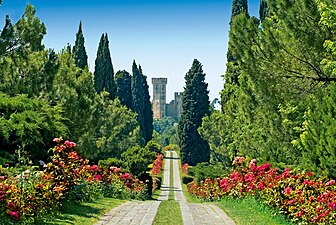 Parco Giardino Sigurtà is a naturalistic park that is home to many different species of plants and flowers
 -
 Countryside around Desenzano. Vines are common in the southern part of the Lake
 -
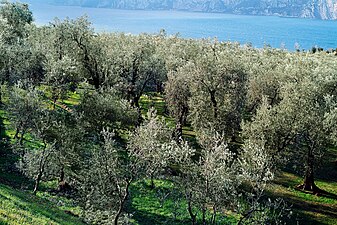 Olive trees
 -
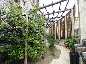 Lemon trees in Limone
.jpg)


History
Traces of human presence around the lake have been found related to the Middle Paleolithic, in particular flint tools, but only above certain altitudes, as at lower altitudes, the actions of the glaciers have cancelled all the clues that could have proved the presence of man. There are some signs of encampments from Upper Paleolithic, in particular on the slopes of Monte Baldo and Stivo. In the Neolithic the populations that inhabited the lake came into contact with the square-mouthed vases culture, as evidenced by the objects accompanying some tombs from this period found near Arco.
Bronze and Iron ages
The greatest evidence of human presence in prehistoric times dates back to the
Roman times

The integration between Romans and Cenomani, who controlled the Garda area, probably began in 225 BC, when there was a treaty of alliance between Cenomani, Veneti and Romans, even if the actual Romanization of the territory took place between the 2nd and 1st centuries BC. In 89 BC the rights of Latin cities were granted to the Garda areas by the will of the Roman consul Gnaeus Pompeius Strabo, while forty years later Roman citizenship was finally granted to Brixia (whose countryside included the western and northern banks of the Benaco) and Verona (which instead included the eastern shore). During the 1st century AD many roads were built, such as the via Gallica, which connected Verona to Milan passing through Peschiera (the ancient Arilica), and the via Claudia Augusta, which connected the plain with the Resia pass and therefore the northernmost territories, as well as some minor roads that connected the Adige valley with the Garda. Two pagi were also established: pagus Benacenses on Brescia and pagus Claudienses on Verona.
In 268 AD the
The Roman presence is amply testified also by settlements, villas (in particular the notes Grottoes of Catullus), by the remains of centuriation still visible today, by the remains of sanctuaries, tombstones and epigraphic testimonies.
Middle Ages


In the Middle Ages Lake Garda was described by Dante in his Divine Comedy:
Suso in Italia bella giace un laco, |
Above in beauteous Italy lies a lake, |
After the collapse of the Roman Empire, the Garda region witnessed the passage of numerous Germanic populations, but the first one that settled there, after a long migration, was that of the Lombards. Their testimonies are mostly present along the southern and eastern shores, preferred to other areas due to their strategic importance: from here it was possible to control both the waterways of Garda and Mincio, and the Adige valley. During the Lombard hegemony, there was a first administrative reorganization, as well as the definitive Christianization of the area, begun in the previous centuries by Vigilius of Trent and Zeno of Verona. The lake remained on the border between three powerful Lombard duchies: Brescia, Verona and Trento.
The first documents that testify the presence of a Fines Gardenses, an entity with its own officials for the administration of justice, even if not autonomous with respect to the Count of Verona, date back to 825, while after the year 1000 county of Garda was established by the emperor
In the 13th century, however, the
Early modern history
In 1387, following the defeat of
In 1508 the
In 1796 the territories of the Serenissima were involved in the
In 1815 following the definitive defeat of
Later modern and contemporary history

The
During the
In the period between the two wars the poet
Until 1943 the events of
Myth and Legend
According to the
In ancient German Sagas, Garda was home to Ortnit.
Towns and villages on the lake
Around Lake Garda there are 26 comuni, the most populated being Desenzano del Garda (29,179 inhabitants), followed by Arco (17,857) and Riva del Garda (17,518).
| Lombardy |
Veneto |
Trentino-Alto Adige/Südtirol |
|---|---|---|
| Province of Brescia (clockwise: south to north) |
Province of Verona (clockwise: north to south) |
Autonomous Province of Trento (clockwise: west to east) |
|
.jpg)


.jpg)


Economy
Tourism

Garda's economy is based on tourism.[9] Back to Roman times, especially from the early imperial age, magnificent villas were present on the shores of the lake, conceived as places dedicated to otium, an activity actually reserved for the ruling classes. In particular Sirmione was a privileged place for the presence of sulphurous springs that allowed thermal use. Starting from the Renaissance the lake returned to be populated with noble villas.
Tourism in the modern conception of the term, however, developed from the end of the 19th century, even if it was still an élite tourism that concerned almost exclusively the north-western area of the lake. One of the first tourist resorts was
On the Veronese shore, tourism arrived much later, around the 1930s, when the current Strada Gardesana Orientale was built along the shores of the lake. With the arrival of tourists, "lakeside promenades" were planned. Since the 1950s tourism has undergone a sort of transformation: tourism with a long stay has been accompanied by "hit and run" tourism, with a short stop, just for the weekend or even for a few hours. The first is fed by tourists who want to spend their holidays on the lake, coming from different areas (in addition to Italians, numerous Germans, French, Swiss and Dutch), while the second is fed by those who live a short distance from the lake and who want to spend a few hours there. Both types of tourism have caused notable changes in the organization of the territory and the inhabited centres.
Furthermore, in the second half of the 20th century, a real entertainment industry was formed along Lake Garda as a series of parks were built. The most important is Gardaland, the biggest Italian theme park which hosts numerous tourist attractions.
Lake Garda is also a popular destination for
Transport
Ferries

Ship transport is provided by Navigazione Laghi. A daily ferry service connects major towns on the eastern and western shores of Lake Garda. The service runs from Desenzano del Garda to Riva del Garda, via Peschiera del Garda, Salò and Malcesine.
Railway
The region can be reached directly via the
Buses


Buses are faster alternatives to ferry services. On the eastern coast, ATV (Verona Transport Company) provides at least five daily bus routes between Verona and Garda, with one route extending to Riva del Garda. Trentino Transporti provides daily bus routes between Riva del Garda and Rovereto or Trento. On the western coast, SAIA (Brescia Mobilità) provides regular bus services between Desenzano del Garda, Salò, Gargnano and Brescia.
Highways
The lake is located at the centre of a crucial node between Brescia, Verona and Trento, and is therefore easily reachable via the transversal infrastructures of the Po Valley and those of the Brenner-Rome axis:
| A4 TURIN – TRIESTE | |||||
| Type | Exit | ↓km↓ | ↑km↑ | Province | European Route |
|---|---|---|---|---|---|
| Brescia Est |
228.8 | 413.5 | BS | ||
| Parking Area "Campagnola" | 232.2 | 409.1 | BS | ||
| Desenzano | 243.9 | 397.4 | BS | ||
| Service Area "Monte Alto" | 244.6 | 396.7 | BS | ||
| Sirmione | 251.3 | 390.0 | BS | ||
| Peschiera | 258.8 | 382.5 | VR | ||
| Castelnuovo del Garda (under construction) |
266.3 | 375.0 | VR | ||
| Parking Area "Val di Sona" | 268.4 | 372.9 | VR | ||
Verona-Villafranca |
270.4 | 370.9 | VR | ||
| Service Area "Monte Baldo" | 271.7 | 369.6 | VR | ||
| 275.3 | 366.0 | VR | |||
| A22 MODENA – BRENNERO | |||||
| 86 | 228 | VR | |||
Verona-Villafranca |
88 | 226 | VR | ||
| Service Area "Garda" | 104 | 210 | VR | ||
Lago di Garda sud |
108 | 206 | VR | ||
| Service Area "Adige" | 128 | 186 | VR | ||
| Ala–Avio | 135 | 179 | TN |
||
Lago di Garda nord |
147 | 167 | TN | ||
Roads
Lake Garda is also served by a road network that runs along the entire lake and is made up of the following infrastructures:
- State Highway 11 Padana Superiore, from Desenzano del Garda to Peschiera del Garda
- State Highway 45bis Gardesana Occidentale, from Salò to Riva del Garda
- State Highway 249 Gardesana Orientale, from Peschiera del Garda to Riva del Garda
- State Highway 572 di Salò, from Desenzano del Garda to Salò
Panoramas


See also
References
- ^ "Origine del toponimo Garda" (in Italian). Retrieved 12 February 2011.
- ISBN 978-1-58843-770-9.
- ^ a b c Froese, Rainer; Pauly, Daniel (eds.) (2006). "Salmo carpio" in FishBase. April 2006 version.
- ^ . Retrieved 3 May 2023.
- ^ .
- ^ "Salmonidae up 10 kg >> Salmo carpio". Fishing Worldrecords. Retrieved 28 November 2016.
- ISBN 978-88-31365-53-6. Retrieved 26 April 2023.
- ^ Virgil, Aeneid, 10.163.
- ^ "Lake Garda Resorts". www.lakegardaholidays.co.uk. Retrieved 28 September 2016.
External links
- VisitGarda is the official website for the promotion of tourism of Lake Garda.
- Gardalombardia is the official website for the promotion of tourism of the western coast of Lake Garda.
- Brescia Tourism is the official tourism board website of Brescia and Garda Lake.
- Coolidge, William Augustus Brevoort (1911). . Encyclopædia Britannica. Vol. 11 (11th ed.). pp. 458–459.
- Lake Garda at Curlie
- Discovering Lake Garda – official Blog lake Garda Trentino
- Tourist Information Lake Garda
| Settlements |
|  |
|---|---|---|
| Islands |
| |
| Rivers | ||
| Wines | ||
| People | ||
| International | |
|---|---|
| National | |
| Geographic | |
| Other | |