
Geringswalde
Geringswalde | |
|---|---|
 View across pond towards Martin Luther church and town hall | |
 Coat of arms | |
Location of Geringswalde within Mittelsachsen district  | |
Mittelsachsen | |
| Government | |
| • Mayor (2022–29) | Sandra Fischer[1] |
| Area | |
| • Total | 29.93 km2 (11.56 sq mi) |
| Elevation | 268 m (879 ft) |
| Population (2022-12-31)[2] | |
| • Total | 4,158 |
| • Density | 140/km2 (360/sq mi) |
| Time zone | UTC+01:00 (CET) |
| • Summer (DST) | UTC+02:00 (CEST) |
| Postal codes | 09326 |
| Dialling codes | 037382 |
| Vehicle registration | FG (formerly MW) |
| Website | www.geringswalde.de |
Geringswalde (German pronunciation: [ɡeːʁɪŋsˈvaldə]) is a town in the district of Mittelsachsen, in Saxony, Germany. It is situated 12 km northwest of Mittweida, and 27 km north of Chemnitz.
History
The town was first mentioned in 1233 in a document confirming the establishment of a
A stream traversing the grounds of the town was dammed in the Middle Ages, forming a large pond known as Großteich.
Until the 19th century, the economy was chiefly based on
In 1949, the neighbouring villages of Hilmsdorf and Klostergeringswalde were incorporated into the town, Altgeringswalde joined in 1994, and in 1999 Aitzendorf (with Dittmannsdorf), Arras, and Holzhausen (with Hoyersdorf and Neuwallwitz) were incorporated.[3]
| Year | Inhabitants[3] |
|---|---|
| 1834 | 2252 |
| 1871 | 2850 |
| 1890 | 2891 |
| 1910 | 4499 |
| 1925 | 4293 |
| 1939 | 4278 |
| 1950 | 6290 |
| 1964 | 5956 |
| 1990 | 4680 |
| 2000 | 5445 |
From 1893 to 1997, the town was served by the
Economy
Traditional occupations were agriculture,
After World War II until the early 1990s the economy of the town was dominated by tool making, furniture making and the production of hydraulic cylinders. Some smaller factories produced clothes, cosmetics, electronic circuits, animal fodder, and concrete parts. Most factories closed in the early 1990s, but the tradition of metalworking in particular is still continued by several small and medium-sized enterprises. A number of wind turbines has been erected on the heights surrounding the town since the 2000s.
Sights
-
 Town hall
 -
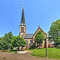 Martin Luther church
 -
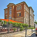 Schoolhouse
 -
 Post milestone (restored)
 -
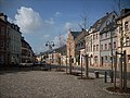 Market square
 -
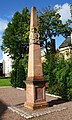
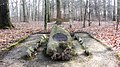 Grave of a fighter in the Napoleonic wars, north of the town


The
A copy of the 1727
A castle in the nearby forest was destroyed in the Middle Ages, only minuscule remains of its basement walls are left.
The village church of Altgeringswalde houses a painted wooden

Personalities
.jpg)
- Wilfried Stallknecht (born 1928), architect, urban planner and furniture designer
- Roselore Sonntag (born 1934), gymnast, Olympic contender in Rome 1960
- Wolfgang Blochwitz (1941-2005), football goalkeeper, played 19 times for the national team of the GDR
References
- ^ Gewählte Bürgermeisterinnen und Bürgermeister im Freistaat Sachsen, Stand: 17. Juli 2022, Statistisches Landesamt des Freistaates Sachsen.
- Statistisches Landesamt des Freistaates Sachsen. 2024.
- ^ a b c d "Digitales Historisches Ortsverzeichnis von Sachsen. Geringswalde". Retrieved 2016-04-26.
- ^ Gottfried August Bernhardi (1777). Beytrag zu einer Geschichte des Städtlein Geringswalda und besonders des ehemals dabey gelegenen St. Marien-Klosters, Benedictiner-Ordens.
- ^ "Sächsische Biographie. Wolf II. Herr von Schönburg". Retrieved 2016-04-26.
- ^ Theodor Distel (1879). Der Flacianismus und die Schönburgsche Landesschule zu Geringswalde.
External links
| International | |
|---|---|
| National | |