
Glee Peak
| Glee Peak | |
|---|---|
 East aspect | |
| Highest point | |
| Elevation | 7,180 ft (2,188 m)[1] |
| Prominence | 920 ft (280 m)[2] |
| Parent peak | McMillan Spire (8,004 ft)[1] |
| Isolation | 1.66 mi (2.67 km)[1] |
| Coordinates | 48°45′15″N 121°15′22″W / 48.754289°N 121.256146°W[2] |
| Naming | |
| Etymology | Glee Glenmore Davis |
| Geography | |
 Glee Peak Location in Washington  Glee Peak Glee Peak (the United States) | |
| Country | United States |
| State | Washington |
| County | Whatcom |
| Protected area | North Cascades National Park |
| Parent range | Cascade Range North Cascades Picket Range |
| Topo map | USGS Mount Challenger |
| Geology | |
| Type of rock | Granodiorite |
| Climbing | |
| Easiest route | scrambling |
Glee Peak is a 7,180-foot-elevation (2,190-meter) mountain
Etymology

Davis Peak, located three miles southeast of Glee Peak, is officially named for the pioneering Davis family, who settled in the Skagit Valley near the base of the mountain.[4] The family was led by Lucinda Davis, the mother of three children, who named her youngest son, Glee Davis (1885–1982). In his later years, Glee would have a homestead here and construct an electric generator on Stetattle Creek.[5] The homestead was lost when Seattle City Light had the land condemned for the purpose of building hydroelectric dams on the Skagit. He also worked for the Forest Service, and in 1917 he built one of the country's first fire lookout towers on nearby Sourdough Mountain after he built the Sourdough Mountain trail in 1916.[6][7] Glee Peak is the unofficial name of this landform, and will remain unofficial as long as the USGS policy of not adopting new toponyms in designated wilderness areas stays in effect.
Geology
The North Cascades features some of the most rugged topography in the
The history of the formation of the Cascade Mountains dates back millions of years ago to the late
During the Pleistocene period, glaciation advancing and retreating repeatedly scoured the landscape leaving deposits of rock debris.[8] The U-shaped cross section of the river valleys is a result of recent glaciation. Uplift and faulting in combination with glaciation have been the dominant processes which have created the tall peaks and deep valleys of the North Cascades area.
Climate
Glee Peak is located in the
Gallery
-
 View from Ruby Mountain, featuring Davis Peak (left), Glee Peak (centered), Mt. Degenhardt/Inspiration Peak (right of center), and the McMillan Spires to the right.
 -
 Southern Picket Range seen from Trappers Peak with Glee Peak in upper right corner of frame.
 -
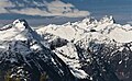
 Northwest aspect


See also
References
- ^ a b c "Glee Peak - 7,180' WA". listsofjohn.com. Retrieved 2022-04-02.
- ^ a b c d "Glee Peak, Washington". Peakbagger.com.
- ^ Fred Beckey (1987), Cascade Alpine Guide: Columbia River to Stevens Pass, Mountaineers Books, p. 97
- ^ Lucinda J. Davis - National Park Service
- ^ Glee Davis, Pioneering in upper Skagit recalled by early settler Glee Davis, Bellingham Herald, June 26, 1953
- ISBN 9781493037087, p. 70
- ^ ISBN 978-0-89886-838-8.
- ^ a b c d Kruckeberg, Arthur (1991). The Natural History of Puget Sound Country. University of Washington Press.
External links
- Glee Peak aerial photo: PBase
- Glee Peak aerial photo: PBase
- Glee Davis biography
- Glee Davis, Skagitriverjournal.com
- Glee Peak with Azure Lake (photo): Summitpost.org
Places adjacent to Glee Peak | |
|---|---|