
Great Linford
| Great Linford | |
|---|---|
 Great Linford Manor | |
 Great Linford Mapping © OpenStreetMap  Great Linford Location within Buckinghamshire | |
| Population | 19,350 (2011 Census)[1] |
| OS grid reference | SP854414 |
| Civil parish |
|
| District | |
| Unitary authority | |
| Ceremonial county | |
| Region | |
| Country | England |
| Sovereign state | United Kingdom |
| Post town | MILTON KEYNES |
| Postcode district | MK14 |
| Dialling code | 01908 |
| Police | Thames Valley |
| Fire | Buckinghamshire |
| Ambulance | South Central |
| UK Parliament | |

Great Linford is a historic village, district and wider
Great Linford village
Great Linford was one of the North Buckinghamshire villages incorporated into Milton Keynes at its designation in 1967.
History
The origin of the name Linford is not recorded.[3][a] The first reference to Linford occurs in 944, when "King Edmund gave to his thegn Aelfheah, land at Linforda with liberty to leave it to whom he wished"; it appears in the Domesday Book as Linforda.[5] Archaeological investigations at the parish church indicate that the site was a Saxon settlement in the seventh century.[6]
In the early sixteenth century, the rector of this parish Dr Richard Napier was widely known as a medical practitioner, astrologer and curer of souls.[5]: Advowson He was referred to by many in the upper classes, including the Earl of Sunderland who lived under his care for some time in 1629.[7]
The village grew in importance following construction in 1800 of the
Education
St. Andrews C. of E. Infant School, on the High Street, was founded in 1901. As part of the development of Milton Keynes, a new primary and middle school was opened in 1977, originally known as Great Linford County Combined School, and more recently as Great Linford Primary School.
Parish church
The parish church of
Other
Great Linford has two pubs: The Nag's Head, on the High Street and The Black Horse at the edge of Great Linford on Wolverton Road, by the Grand Union Canal. There is a new Memorial Hall and a Community Hall off Marsh Drive behind the manor house.
Linford Manor is now owned by Pete Winkelman who is chairman of Milton Keynes Dons F.C.[12] The former stables and associated gate houses are now an Arts Centre.[13] As of 2022[update], the former almshouses are not in use but in February 2022, Milton Keynes Council transferred them into the care of the Parks Trust and they are scheduled to be restored.[14]
Civil parish
In addition to Great Linford district itself (with the historic village at its core), the civil parish also includes the districts of Bolbeck Park/Giffard Park, Blakelands, Neath Hill, Pennyland, Tongwell, Conniburrow, Downs Barn, Downhead Park and Redhouse Park.
The parish is bounded to the north by Newport Road, to the west by the B4034/V8 Marlborough Street (as far as H4 Dansteed Way), then along Dansteed Way as far as V7 Saxon Street, south along Saxon Street as far as the A509/H5 Portway, then east along Portway to the M1, then north along the motorway until it reaches Newport Road again. The Grand Union Canal bisects the parish.
The parish increased in population from 263 in the 1971 census to 11,882 in the 1981 census, an increase of some 4,400%. At the 2011 census, the population had reached 19,350,[1] and the 2021 census is expected to show a further increase because of construction of Redhouse Park in the intervening period.
Listed buildings and structures
The parish has four Grade II*
Images of Great Linford CP
-
 The Pavilions at Great Linford Arts Centre
 -
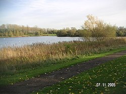 Tongwell Lake, a balancing lake, viewed in a south-easterly direction
 -
 The Nags Head, Great Linford village
 -
 Almshouses at Great Linford
 -
 St Andrew's Church


See also
- Little Linford in the adjoining parish of Haversham-cum-Little Linford.
- Linford Wood in the adjoining Stantonbury parish.
Notes
- ^ The Great Linford History Society conjectures that the name may originate from the Old English hlin (a tree, possibly a maple); lind, a lime tree (linden tree); or linen; combined with 'ford' (over the Great Ouse that separates Great Linford from Little Linford to the north). The Society emphasises that this etymology is purely speculative.[4]
References
- ^ Office for National Statistics. Retrieved 17 November 2019.
- Milton Keynes Council. Retrieved 10 October 2020.
- ^ "Key to English place names". Institute for Name-Studies, University of Nottingham. Retrieved 11 April 2022. This is UK's primary reference for toponymy: it has no record for any Linford whereas it does have records for many of the nearby settlements.
- ^ "Great Linford History: About Great Linford village, parish and park". Great Linford History Society. Retrieved 11 April 2022.
- ^ Victoria History of the Counties of England. Vol. 4. London: Constable & Co. Ltd.pp. 387–392.
- ^ "About Great Linford Manor Park". Milton Keynes Parks Trust.
- ^ "Great Linford". GEN UKI. Archived from the original on 11 September 2011. Retrieved 9 January 2012.
- ^ ISBN 978-0903379052.
- ^ a b "Sir William Pritchard". Milton Keynes Parks Trust. Retrieved 11 April 2022.
- ISBN 071534871X.
- ^ a b Historic England (17 November 1966). "Church of Saint Andrew, High Street (Grade II*) (1160090)". National Heritage List for England. Retrieved 29 March 2022.
- ^ Jackson, Jamie (30 March 2008). "From Wimbledon to Winkelman, a crazy new journey". The Observer. Retrieved 9 January 2012.
- ^ "Artworks MK (Archived copy)". Archived from the original on 30 July 2012. Retrieved 30 July 2012.
- ^ "The Parks Trust enter agreement with Milton Keynes Council to take on lease of historic Almshouses". MKFM. 1 February 2022.
- ^ Historic England. "Former school house and almshouses (Grade II*) (1125275)". National Heritage List for England.
- ^ Historic England. "Linford Manor (Grade II*) (1125276)". National Heritage List for England.
- ^ Historic England. "Stable blocks, to west of Linford Manor (Grade II*) (1310704)". National Heritage List for England. ("the Pavilions")
- ^ "Search the List – Advanced Search (parish=Great Linford)". Historic England. Retrieved 12 April 2022.
- ^ Great Linford Brickworks Scheduled monument.No. 1006927
External links
- Ordnance Survey (1886). "Buckinghamshire Sheet X" (Map). Great Linford in 1881. 1:10,560. National Library of Scotland. Retrieved 23 November 2021.
- The village on navigable 1946 O. S. map