
Grebenau
Grebenau | |
|---|---|
 Coat of arms | |
Location of Grebenau within Vogelsbergkreis district 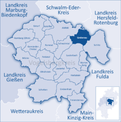 | |
Gießen | |
| District | Vogelsbergkreis |
| Subdivisions | 7 Stadtbezirke |
| Government | |
| • Mayor (2019–25) | Lars Wicke[1] (FW) |
| Area | |
| • Total | 55.37 km2 (21.38 sq mi) |
| Elevation | 286 m (938 ft) |
| Population (2022-12-31)[2] | |
| • Total | 2,394 |
| • Density | 43/km2 (110/sq mi) |
| Time zone | UTC+01:00 (CET) |
| • Summer (DST) | UTC+02:00 (CEST) |
| Postal codes | 36323 |
| Dialling codes | 06646 |
| Vehicle registration | VB |
| Website | www.grebenau.de |
Grebenau (German pronunciation: [ˈɡʁeːbənaʊ̯] ⓘ) is a town in the Vogelsbergkreis in Hesse, Germany.
Geography
Location
Lying from 220 to 350 m above sea level, Grebenau is northeast of the Vogelsberg some 26 km northwest of Fulda, at the place where the Schwarza empties into the Jossa, itself a tributary to the Fulda.
Neighbouring communities
Grebenau borders in the north on the town of
Schlitz, in the south on the town of Lauterbach, and in the west on the community of Schwalmtal, Hesse
.
Constituent communities
- Bieben, representative Klaus Gaudl
- Merlos – belongs to Bieben
- Eulersdorf, representative Ernst Hölscher
- Grebenau, representative Lotti Frick
- Reimenrod, representative Gerhard Agel
- Schwarz, representative Klaus Weitzel
- Udenhausen, representative Herbert Schäfer
- Wallersdorf, representative Gerd-Dieter Kaiser
Politics
Town council
This section needs to be updated. (July 2021) |
Chairman:
Herbert Appel (SPD)
- CDU: 6 seats, factional chairman Gerd-Dieter Kaiser
- SPD: 6 seats, factional chairman Helmut Ihm
- FWG (citizens' coalition): 3 seats, factional chairman Rudolf Dippel
(as of municipal elections held on 26 March 2006)
References
- Hessisches Statistisches Landesamt. 5 September 2022.
- Hessisches Statistisches Landesamt. June 2023.
Towns and municipalities in Vogelsberg (district) | ||
|---|---|---|
| International | |
|---|---|
| National | |