
Ulrichstein
Ulrichstein | |
|---|---|
 The castle | |
 Coat of arms | |
Location of Ulrichstein within Vogelsbergkreis district 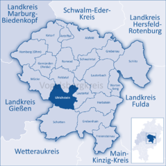 | |
Gießen | |
| District | Vogelsbergkreis |
| Government | |
| • Mayor (2017–23) | Edwin Schneider[1] (Ind.) |
| Area | |
| • Total | 65.61 km2 (25.33 sq mi) |
| Elevation | 614 m (2,014 ft) |
| Population (2022-12-31)[2] | |
| • Total | 3,028 |
| • Density | 46/km2 (120/sq mi) |
| Time zone | UTC+01:00 (CET) |
| • Summer (DST) | UTC+02:00 (CEST) |
| Postal codes | 35327 |
| Dialling codes | 06645 |
| Vehicle registration | VB |
| Website | www.ulrichstein.de |
Ulrichstein (German pronunciation: [ˈʊlʁɪçˌʃtaɪ̯n] ) is a small town in the Vogelsbergkreis in Hesse, Germany.
Geography
Location
Ulrichstein lies in the
It is a recognized state-approved climatic spa and lies near the High Hoherodskopf nature reserveNortheast of town is the source of the river
Ohm, the "Omquelle"[4]
Matthäus Merian
, 1655Neighboring communities
Ulrichstein borders in the north on the community of
Gießen district), and in the west on the community of Mücke
.
Constituent communities
In 1972, the town of Ulrichstein and the communities of Kölzenhain, Feldkrücken and Rebgeshain from the Lauterbach district, along with the communities of Bobenhausen, Helpershain, Ober-Seibertenrod, Unter-Seibertenrod and Wohnfeld from the Alsfeld district merged into a new municipality, today's town of Ulrichstein.
References
- Hessisches Statistisches Landesamt. 5 September 2022.
- Hessisches Statistisches Landesamt. June 2023.
- ^ "Ulrichstein - Geopark Vogelsberg". www.geopark-vogelsberg.de. Retrieved 2023-01-27.
- ^ "Ulrichstein - Die Ohmquelle". www.ulrichstein.de (in German). Retrieved 2023-01-27.
External links
Towns and municipalities in Vogelsberg (district) | ||
|---|---|---|
| International | |
|---|---|
| National | |
| Geographic | |